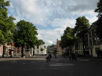
Domplein (Dom Square), Utrecht
Just like many other medieval European cities, Utrecht has its fair share of city squares. But it has been said that there is only one that matters--Dom Square. Home to the impressive Dom Church, history abounds above and below this beautiful plaza.
Dom Square's history goes back to Roman times. The original settlement was a castellum at a ford near the river Rhine. This original settlement was called Trajectum, which translates to "crossing point." As a monument to that history, the city has lights in the road surface that outline the wall of the original castellum.
The best way to taste the centuries of history here is to visit the DOMunder Museum, the entrance to which is right in the center of the square. From there, you can see parts of the original castellum and foundations from the original Dom Church.
In the 11th century, this was the site of the Lofen imperial palace. Unfortunately, a massive nine-day-long fire in 1253 burned it to the ground, along with most other buildings in the square. However, parts of the palace are still visible in some of the cellars of surrounding buildings. These are being opened soon and will eventually be part of the DOMunder Museum.
The most prominent feature in the square today is the Domkerk, otherwise known as Dom Church. Opposite the church is Dom Tower, a Gothic bell tower with 465 steps that leads to a fantastic panoramic view of Utrecht. The original cathedral connected the two--the tower was meant to be part of the larger structure. But a tornado in 1674 destroyed the unfinished nave, and the two structures were never again connected.
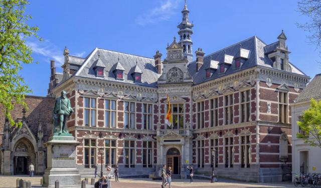
On the south side of the square lies the University of Utrecht. Between it and the Dom Church is one of the can't-miss sights at the square, the beautiful Dom Church Gardens.
Several monuments are dispersed throughout the square, including one statue of Count Jan van Nassau. Van Nassau is shown carrying a piece of paper, his Union of Utrecht--the charter he drew in 1579 between several Dutch regions.
There is also a monument dedicated to the resistance movement during World War II. The statue was dedicated in 1949 and created by Corinne Franzén-Heslenfeld.
Dom Square's history goes back to Roman times. The original settlement was a castellum at a ford near the river Rhine. This original settlement was called Trajectum, which translates to "crossing point." As a monument to that history, the city has lights in the road surface that outline the wall of the original castellum.
The best way to taste the centuries of history here is to visit the DOMunder Museum, the entrance to which is right in the center of the square. From there, you can see parts of the original castellum and foundations from the original Dom Church.
In the 11th century, this was the site of the Lofen imperial palace. Unfortunately, a massive nine-day-long fire in 1253 burned it to the ground, along with most other buildings in the square. However, parts of the palace are still visible in some of the cellars of surrounding buildings. These are being opened soon and will eventually be part of the DOMunder Museum.
The most prominent feature in the square today is the Domkerk, otherwise known as Dom Church. Opposite the church is Dom Tower, a Gothic bell tower with 465 steps that leads to a fantastic panoramic view of Utrecht. The original cathedral connected the two--the tower was meant to be part of the larger structure. But a tornado in 1674 destroyed the unfinished nave, and the two structures were never again connected.
On the south side of the square lies the University of Utrecht. Between it and the Dom Church is one of the can't-miss sights at the square, the beautiful Dom Church Gardens.
Several monuments are dispersed throughout the square, including one statue of Count Jan van Nassau. Van Nassau is shown carrying a piece of paper, his Union of Utrecht--the charter he drew in 1579 between several Dutch regions.
There is also a monument dedicated to the resistance movement during World War II. The statue was dedicated in 1949 and created by Corinne Franzén-Heslenfeld.
Want to visit this sight? Check out these Self-Guided Walking Tours in Utrecht. Alternatively, you can download the mobile app "GPSmyCity: Walks in 1K+ Cities" from Apple App Store or Google Play Store. The app turns your mobile device to a personal tour guide and it works offline, so no data plan is needed when traveling abroad.
Download The GPSmyCity App
Domplein (Dom Square) on Map
Sight Name: Domplein (Dom Square)
Sight Location: Utrecht, Netherlands (See walking tours in Utrecht)
Sight Type: Attraction/Landmark
Guide(s) Containing This Sight:
Sight Location: Utrecht, Netherlands (See walking tours in Utrecht)
Sight Type: Attraction/Landmark
Guide(s) Containing This Sight:
Walking Tours in Utrecht, Netherlands

Create Your Own Walk in Utrecht
Creating your own self-guided walk in Utrecht is easy and fun. Choose the city attractions that you want to see and a walk route map will be created just for you. You can even set your hotel as the start point of the walk.
Utrecht's Historical Buildings Walking Tour
Originally founded by the Romans, and once the most important city in the Netherlands, Utrecht boasts a generous share of historically significant structures. The collection of its architectural masterpieces, one of the richest in the country, dates back to the early Middle Ages.
The amazingly well-preserved pieces of historic architecture in Utrecht showcase the trends and movements throughout... view more
Tour Duration: 2 Hour(s)
Travel Distance: 3.8 Km or 2.4 Miles
The amazingly well-preserved pieces of historic architecture in Utrecht showcase the trends and movements throughout... view more
Tour Duration: 2 Hour(s)
Travel Distance: 3.8 Km or 2.4 Miles
Utrecht Introduction Walking Tour
The earliest settlers to the area now called Utrecht likely arrived millennia ago during the Stone Age. While there are also signs of inhabitation during the Bronze Age, scholars today credit the Romans with building what became the town.
They set up a castellum around the year 50 AD, a fort right at a crossing point on the river Rhine. The fortress marked Rome's northernmost point in... view more
Tour Duration: 1 Hour(s)
Travel Distance: 1.6 Km or 1 Miles
They set up a castellum around the year 50 AD, a fort right at a crossing point on the river Rhine. The fortress marked Rome's northernmost point in... view more
Tour Duration: 1 Hour(s)
Travel Distance: 1.6 Km or 1 Miles