

Sugar-Loaf Hill, Naha
Sugar‑Loaf Hill, locally known as Hill 52, may seem modest today-rising just about 50 feet above the surrounding plain-but it bears an outsized historical significance. This small elevation once formed the western anchor of the strategic Shuri district defense line during the pivotal Battle of Okinawa in May 1945. While its name might suggest a tranquil landmark, it earned infamy as one of the bloodiest battlegrounds on the island.
From May 12 to May 18, United States Marines of the 6th Division launched relentless assaults to seize Sugar‑Loaf from entrenched Japanese forces. The hill’s reverse‑slope defenses and interconnected bunkers allowed defenders to repel multiple assaults. Over the week, the Marines suffered approximately 2,662 casualties, with many others evacuated due to mental fatigue and combat stress, while Japanese troops also sustained heavy losses-rendering the hill a symbol of sacrifice and endurance.
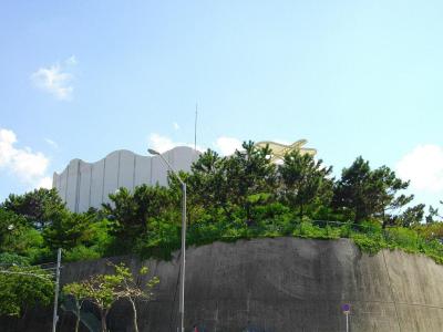
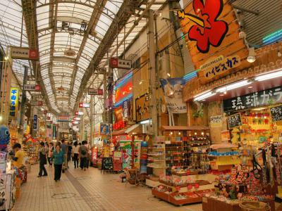
Today, Sugar‑Loaf Hill has been integrated into Naha’s urban landscape. Atop the hill stands a water tower and a modest memorial plaque, marking its somber past. The surrounding area has transformed into a shopping and transit hub, offering a contrast between daily life and the echoes of wartime struggle.
From May 12 to May 18, United States Marines of the 6th Division launched relentless assaults to seize Sugar‑Loaf from entrenched Japanese forces. The hill’s reverse‑slope defenses and interconnected bunkers allowed defenders to repel multiple assaults. Over the week, the Marines suffered approximately 2,662 casualties, with many others evacuated due to mental fatigue and combat stress, while Japanese troops also sustained heavy losses-rendering the hill a symbol of sacrifice and endurance.
Today, Sugar‑Loaf Hill has been integrated into Naha’s urban landscape. Atop the hill stands a water tower and a modest memorial plaque, marking its somber past. The surrounding area has transformed into a shopping and transit hub, offering a contrast between daily life and the echoes of wartime struggle.
Want to visit this sight? Check out these Self-Guided Walking Tours in Naha. Alternatively, you can download the mobile app "GPSmyCity: Walks in 1K+ Cities" from Apple App Store or Google Play Store. The app turns your mobile device to a personal tour guide and it works offline, so no data plan is needed when traveling abroad.
Download The GPSmyCity App
Sugar-Loaf Hill on Map
Sight Name: Sugar-Loaf Hill
Sight Location: Naha, Japan (See walking tours in Naha)
Sight Type: Attraction/Landmark
Sight Location: Naha, Japan (See walking tours in Naha)
Sight Type: Attraction/Landmark
Nearby Sights


Walking Tours in Naha, Japan

Create Your Own Walk in Naha
Creating your own self-guided walk in Naha is easy and fun. Choose the city attractions that you want to see and a walk route map will be created just for you. You can even set your hotel as the start point of the walk.
Shuri District Walking Tour
Once an independent city and the esteemed royal capital of the Ryūkyū Kingdom, Shuri has been a district in the city of Naha since 1954. Originally established as a castle town surrounding the royal palace, Shuri's status as the capital ceased with the dissolution of the kingdom and its incorporation into Japan as part of Okinawa prefecture. Renowned for its historical significance, today... view more
Tour Duration: 2 Hour(s)
Travel Distance: 3.8 Km or 2.4 Miles
Tour Duration: 2 Hour(s)
Travel Distance: 3.8 Km or 2.4 Miles
Naha Introduction Walking Tour
Naha, the dynamic capital of Okinawa, Japan, although small a city as such, does contain a plethora of historic attractions. Recognizing it as the birthplace of Okinawa karate also adds greatly to the city's appeal among sports enthusiasts.
Naha derives its name from the word "Naba," which references a large stone shaped like a mushroom that once graced the city but over time... view more
Tour Duration: 2 Hour(s)
Travel Distance: 3.7 Km or 2.3 Miles
Naha derives its name from the word "Naba," which references a large stone shaped like a mushroom that once graced the city but over time... view more
Tour Duration: 2 Hour(s)
Travel Distance: 3.7 Km or 2.3 Miles