

Tajo de Ronda (Ronda Gorge), Ronda (must see)
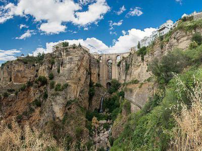
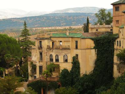
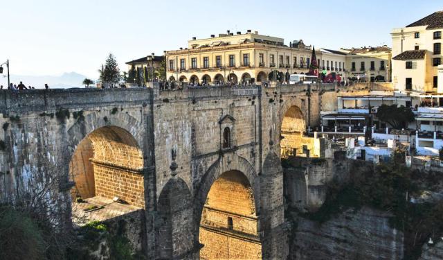
Ronda’s soul is literally split in two by the Ronda Gorge, a gaping 394-foot fissure carved by the stubborn Guadalevín River as it rushes down from the Snowy Mountains. On one rim sits the storybook Moorish Old Town, and on the other, the bustling Little Market of modern life. Down at the bottom, you can spy the river’s ancient trickle powering ruined flour mills-victims of the great 1917 landslide-while steep trails beckon the brave to clamber alongside the canyon walls.
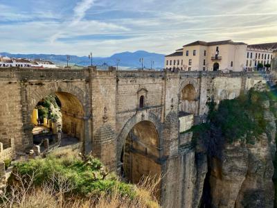
Spanning this vertical drama is the New Bridge, its Romanesque arches soaring almost 100 meters above the torrent. From the bridge’s edge, your gaze sweeps across the entire gorge, the valley below, and even the Grazalema Mountains on a clear day. Fancy a closer look? Start at the Roman Bridge and follow the rugged east-bank trail down to tranquil ponds linked by old mill canals. If you’d rather stay dry, pop into Hostel Los Molinos-housed in a restored water mill-for prime viewing of the west cliff face.
For a real hydraulic thrill, descend the Water Mine steps at the House of the Moorish King, where 14th-century engineers carved a well all the way down to river level. Legend says Christian slaves climbed those same stairs carrying water skins-proof that Ronda’s eagerness for lofty views goes back centuries.
Old customs may be as stubborn as the stone walls, but one thing’s timeless: Ronda’s views are simply unbeatable.
Want to visit this sight? Check out these Self-Guided Walking Tours in Ronda. Alternatively, you can download the mobile app "GPSmyCity: Walks in 1K+ Cities" from Apple App Store or Google Play Store. The app turns your mobile device to a personal tour guide and it works offline, so no data plan is needed when traveling abroad.
Download The GPSmyCity App
Tajo de Ronda (Ronda Gorge) on Map
Sight Name: Tajo de Ronda (Ronda Gorge)
Sight Location: Ronda, Spain (See walking tours in Ronda)
Sight Type: Attraction/Landmark
Guide(s) Containing This Sight:
Sight Location: Ronda, Spain (See walking tours in Ronda)
Sight Type: Attraction/Landmark
Guide(s) Containing This Sight:
Nearby Sights
Walking Tours in Ronda, Spain

Create Your Own Walk in Ronda
Creating your own self-guided walk in Ronda is easy and fun. Choose the city attractions that you want to see and a walk route map will be created just for you. You can even set your hotel as the start point of the walk.
Ronda Introduction Walking Tour
Imagine a city so dramatic it naturally inspired myth and empire-welcome to Ronda, where every cliff, gate, and square flaunts history. Before the Romans and Visigoths muscled in, Celtic tribes called this rocky promontory Arunda. The Phoenicians and Romans left their mark, but it was the Umayyads in 713 who gave us Rundah, which means the “Castle on the Cliff.” Next up, in 1485, and Rodrigo,... view more
Tour Duration: 2 Hour(s)
Travel Distance: 2.8 Km or 1.7 Miles
Tour Duration: 2 Hour(s)
Travel Distance: 2.8 Km or 1.7 Miles