

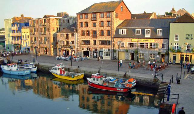
Belvedere, Plymouth
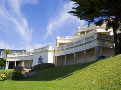
Lying on the seaward side of Plymouth Hoe and originally known as the Public Shelter, the Belvedere is more commonly referred to as the 'Wedding Cake'. The nick is due to the layered structure of the building, with an open colonnaded front and a pompous staircase.
As for the actual name, Belvedere, it derives from the two Italian words: 'bel' which means 'beautiful' and 'vedere' meaning 'to see/view'. Indeed, this fine terraced summer house, which once served as the ornate entrance to Promenade Pier (one of the Hoe’s greatest attractions), affords visitors a rather breathtaking view of Plymouth’s beautiful coastline.
The Wedding Cake has three levels and under its steps you can actually see the remains of the old Plymouth Promenade Pier, where it once met the land. The Belvedere was constructed in 1891 and tradition says that the pillars of its two upper tiers are reused 17th-century granite Tuscan columns taken from the old Market.
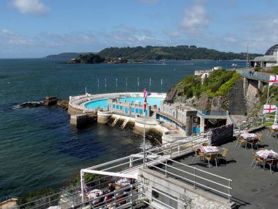
Throughout the 1800s, regular political meetings were held right below the Belvedere, in what used to be the so-called the Bull Ring. In the early 1900s, people would come here to meet friends and go out for a dance or a concert at the Pier. As well as tea dances and musical concerts, another event that drew crowds to the Wedding Cake and the surrounding area, was a swimming regatta in the Sound. Thousands of people would gather to watch the swimming, for which reason, some of the steps down on West Hoe are bum-sized, i.e. sized to one's bottom so as to fit as many people in as possible on the steps to watch the regatta.
Unfortunately, a lot of Plymouth was bombed in WWII, and the Pier caught fire during the Plymouth Blitz in 1941. What was left of it had to be demolished in the early 1950s, so the Wedding Cake is the only bit of it that lives on, much as the tales of the Pier's former splendour.
As for the actual name, Belvedere, it derives from the two Italian words: 'bel' which means 'beautiful' and 'vedere' meaning 'to see/view'. Indeed, this fine terraced summer house, which once served as the ornate entrance to Promenade Pier (one of the Hoe’s greatest attractions), affords visitors a rather breathtaking view of Plymouth’s beautiful coastline.
The Wedding Cake has three levels and under its steps you can actually see the remains of the old Plymouth Promenade Pier, where it once met the land. The Belvedere was constructed in 1891 and tradition says that the pillars of its two upper tiers are reused 17th-century granite Tuscan columns taken from the old Market.
Throughout the 1800s, regular political meetings were held right below the Belvedere, in what used to be the so-called the Bull Ring. In the early 1900s, people would come here to meet friends and go out for a dance or a concert at the Pier. As well as tea dances and musical concerts, another event that drew crowds to the Wedding Cake and the surrounding area, was a swimming regatta in the Sound. Thousands of people would gather to watch the swimming, for which reason, some of the steps down on West Hoe are bum-sized, i.e. sized to one's bottom so as to fit as many people in as possible on the steps to watch the regatta.
Unfortunately, a lot of Plymouth was bombed in WWII, and the Pier caught fire during the Plymouth Blitz in 1941. What was left of it had to be demolished in the early 1950s, so the Wedding Cake is the only bit of it that lives on, much as the tales of the Pier's former splendour.
Want to visit this sight? Check out these Self-Guided Walking Tours in Plymouth. Alternatively, you can download the mobile app "GPSmyCity: Walks in 1K+ Cities" from Apple App Store or Google Play Store. The app turns your mobile device to a personal tour guide and it works offline, so no data plan is needed when traveling abroad.
Download The GPSmyCity App
Belvedere on Map
Sight Name: Belvedere
Sight Location: Plymouth, England (See walking tours in Plymouth)
Sight Type: Attraction/Landmark
Guide(s) Containing This Sight:
Sight Location: Plymouth, England (See walking tours in Plymouth)
Sight Type: Attraction/Landmark
Guide(s) Containing This Sight:
Nearby Sights


Walking Tours in Plymouth, England

Create Your Own Walk in Plymouth
Creating your own self-guided walk in Plymouth is easy and fun. Choose the city attractions that you want to see and a walk route map will be created just for you. You can even set your hotel as the start point of the walk.
Plymouth Hoe Walking Tour
Plymouth Hoe, referred to locally as the Hoe, is a large south-facing open public space in Plymouth with commanding views of Plymouth Sound, Drake's Island, and further afield into Cornwall. The name derives from the Anglo-Saxon word hoh, which means a sloping ridge shaped like an inverted foot and heel.
This part of town has always been a meeting place, where people would come regularly... view more
Tour Duration: 1 Hour(s)
Travel Distance: 0.7 Km or 0.4 Miles
This part of town has always been a meeting place, where people would come regularly... view more
Tour Duration: 1 Hour(s)
Travel Distance: 0.7 Km or 0.4 Miles
Plymouth Introduction Walking Tour
Plymouth's early history began in the Bronze Age when the first settlement emerged at Mount Batten. It is mentioned in Ptolemy's Geographia as a maritime outpost exporting bronze mirrors.
The settlement was a major port in the southwest of England in Roman times. It was surpassed as a port in the ninth century by the nearby wealthier village of Sutton, later called Plymouth.
... view more
Tour Duration: 1 Hour(s)
Travel Distance: 1.9 Km or 1.2 Miles
The settlement was a major port in the southwest of England in Roman times. It was surpassed as a port in the ninth century by the nearby wealthier village of Sutton, later called Plymouth.
... view more
Tour Duration: 1 Hour(s)
Travel Distance: 1.9 Km or 1.2 Miles

Pilgrim Fathers Trail
Back in the early 17th century, a group of English Puritans – nowadays reverently referred to as the Pilgrim Fathers – fled religious persecution in their homeland and established a colony in North America that later became known as Plymouth, Massachusetts. The Pilgrims embarked on their perilous journey across the Atlantic from Plymouth, England in 1620 aboard a ship called the Mayflower,... view more
Tour Duration: 1 Hour(s)
Travel Distance: 0.5 Km or 0.3 Miles
Tour Duration: 1 Hour(s)
Travel Distance: 0.5 Km or 0.3 Miles