Plymouth Introduction Walking Tour, Plymouth

Plymouth Introduction Walking Tour (Self Guided), Plymouth

Plymouth's early history began in the Bronze Age when the first settlement emerged at Mount Batten. It is mentioned in Ptolemy's Geographia as a maritime outpost exporting bronze mirrors.

The settlement was a major port in the southwest of England in Roman times. It was surpassed as a port in the ninth century by the nearby wealthier village of Sutton, later called Plymouth.

Plymouth was closely associated with two historic events. Plymouth was the base of the English fleet that defeated the Spanish Armada in 1588. The battle changed the fortunes of these countries. In 1620 a group of pilgrims seeking religious freedom departed Plymouth for the New World on the ship Mayflower. That epic journey changed the world.

During the Industrial Revolution, Plymouth became a major Naval base and shipbuilding city. To this day, the city's economy is partially reliant on shipbuilding and seafaring, but it is also strongly influenced by service industries.

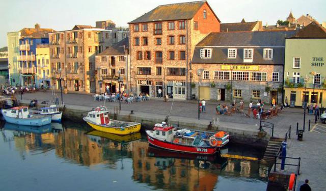
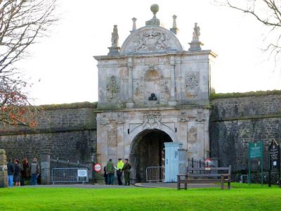
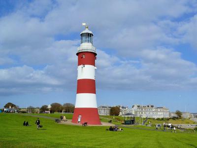
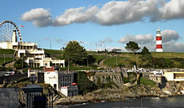
The old city center is referred to as the Barbican. It is so named for two bastions included in the Royal Citadel that was built in the time of Francis Drake. The citadel was built in 1666 to defend against attacks by sea or by Parliamentarians. West of the citadel is Smeaton's Tower, formerly the Eddystone Light.

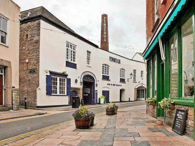
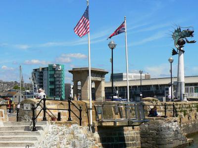
Plymouth has 20 war memorials, nine of which are located on the Hoe, a green area over limestone cliffs overlooking the harbor and the sea. The Barbican has 100 listed buildings and the most cobbled streets in Britain. Before leaving for the New World, the Pilgrims boarded the Mayflower from the steps on the West Pier. Some had their last meal at the Gin Distillery nearby.

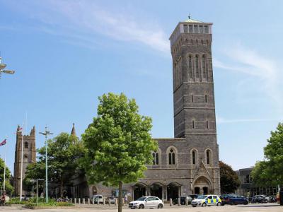
Rebuilt after World War II, Plymouth has all the attractions of a modern city with a well-preserved past. Visit this link between the Old World and the New. See the past and the future together.
How it works: Download the app "GPSmyCity: Walks in 1K+ Cities" from Apple App Store or Google Play Store to your mobile phone or tablet. The app turns your mobile device into a personal tour guide and its built-in GPS navigation functions guide you from one tour stop to next. The app works offline, so no data plan is needed when traveling abroad.

Download The GPSmyCity App

Plymouth Introduction Walking Tour Map

Guide Name: Plymouth Introduction Walking Tour
Guide Location: England » Plymouth (See other walking tours in Plymouth)
Guide Type: Self-guided Walking Tour (Sightseeing)
# of Attractions: 7
Tour Duration: 1 Hour(s)
Travel Distance: 1.9 Km or 1.2 Miles
Author: VictoriaB
Sight(s) Featured in This Guide:
  • Guildhall
  • Plymouth Synagogue
  • Merchants House
  • Plymouth Gin Distillery
  • Mayflower Steps
  • Royal Citadel
  • Smeaton's Tower
1
Guildhall

1) Guildhall

Historically, Plymouth has had five guild halls. The first guilt hall, dated back to the 15th century, was located in the Old Town section of Plymouth. It was replaced by the second hall erected in the Southside Street / Wooster Street area in 1440. In 1607, a third hall, a Jacobean structure, was built on High Street. It was demolished in 1800 and replaced by the fourth guilt hall, designed by John Eveleigh, a surveyor, and architect from Bath. The fifth and current Guildhall foundation stone was laid in July 1870. This one proved to be a keeper.

Guildhall was created by Edward William Godwin, a progressive designer and architect. Godwin's Gothic Revival hall was opened by Edward, Prince of Wales, in August 1874. The Guildhall block was 292 feet long and included the Assize Courts.

On the south corner of the building, the great tower commanded the block, rising to 190 feet. Over the center of the Guildhall was a spire with a finial 140 feet above the ground. Internally, the main room, the Great Hall, features a nave of 58 feet wide and 70 feet high. Granite pillars separated it from the aisles. The hall was designed to hold up to 2,600 people.

In 1941, the Guildhall and surrounding buildings were damaged during the Plymouth Blitz, a series of bombing raids of the Second World War. The restoration work started in 1954 and finished in 1959. The hall was rebuilt according to the plans of City Architect Hector J. W. Stirling.

The interior of the building features a wide marble staircase that leads to the Great Hall. The mahogany-paneled upper hall measures 106 feet by 57 feet. The lower entry is underneath. Three chandeliers in the Great Hall represent the old "Three Towns" (Plymouth, Stonehouse, and Devonport). The vast Gobelin Tapestry of Raphael's "Miracle of the Fishes" is a gift from Napoleon III.

The Grade II listed building, today Guildhall acts as a venue for a wide variety of events throughout the year, including graduations, awards, weddings, and concerts.
2
Plymouth Synagogue

2) Plymouth Synagogue

Jewish immigrants arrived in Plymouth in the 1700s from the Germanic lands and the Netherlands. The Ashkenazi community of Plymouth built its synagogue there in 1762. The Plymouth Synagogue continues to serve its congregation today as the oldest extant Ashkenazi synagogue in the English-speaking world.

The founding community was mainly members of the very extended Emden family. They were planning their synagogue in 1758. In 1762 building land lease was signed by Samuel Champion, a non-Jew, since leases signed by Jews were not legal. The congregation bought the land outright in 1834.

There are no records of the architect's name who designed the synagogue. It is assumed that the rectangular, pitched-roof structure was designed and erected by a local master builder. The building is plain, made of whitewashed brick, and covered with a roof of grey slate. The synagogue seems to be hidden, which is likely. The building looks quite like a nonconformist Protestant church.

An adjacent building of 1874 houses several synagogue offices. A white-tiled ritual bath (mikveh) is next to the vestry. The interior is plain except for the Torah Ark, the chamber for the sacred scrolls. The Ark is an ornate structure two stories high. It has Corinthian fluted columns, a pediment with finials, and urns in gold.

The Ten Commandments, in gold leaf on a blue background, adorn the second-story cornice. The Torah Ark is a free-standing structure imported from Holland and assembled in Plymouth.
3
Merchants House

3) Merchants House

William Parker, sea dog, privateer, businessman, adventurer, and colleague in plunder to Sir Francis Drake, was the earliest recorded owner of the Merchants House at 33 St Andrew's Street, Plymouth. He was also Lord Mayor of Plymouth from 1601 to 1602. Parker served under Drake in the battle against Spanish Armada in 1588.

Parker broke into the big time in 1601 when he captured two Spanish treasure ships carrying at least 10,000 gold ducats. On his return home, he was elected Lord Mayor and used his profits to remodel the old house on St Andrew's Street. The house was rebuilt in a fashionable Elizabethan style, featuring a half-timbered, twin-peaked building with many windows.

Parker is also known to help promote the Plymouth Company to colonize North America and took an active interest in the Virginia Colony. He died in 1618 while on a voyage to the East Indies. The Parker family lived in the house until 1632. In the 1960s, the property was used as a tax office, then restored by the City Council and turned into a museum, focussing on life in Plymouth over time.

The seven rooms of the house are each dedicated to a particular period of Plymouth history. There is a Victorian schoolroom or the room that recreates the experience of the World War II Blitzkrieg in Plymouth. The Museum is temporarily closed for restoration.
4
Plymouth Gin Distillery

4) Plymouth Gin Distillery (must see)

Located in the Barbican district of Plymouth, the Plymouth Gin Distillery dates from the early 1400s. The most intact part of the distillery is the Refectory Room, a medieval hall with a fine hull-shaped timber roof built in 1431. It is one of the oldest buildings in Plymouth, protected as a precious national monument. It is said that the Distillery buildings were once a monastery of the Dominican Black Friars.

In 1536 the Black Friars monastery fell victim to the storms of the Reformation. The monastery was dissolved, and the buildings were used as a Marshalsea (debtors' prison). It was later a non-Conformist meeting hall and a haven for Huguenot refugees fleeing France.

According to local legend, in 1620, some Pilgrim Fathers spent their last night in England at the old monastery while their ship, Mayflower, was in the harbor for repairs before finally setting sail to North America. This is where the Mayflower on Plymouth Gin's trademark originated.

Black Friars has had a working gin distillery on the premises since 1697. In 1793, the distillery of Coates & Company was joined by the firm of Fox & Williamson. The business retained the name of Coates & Company. In 2005 the firm was acquired by the Swedish company V&S Group and later by the French company Pernod-Ricard.

Plymouth Gin is an actual brand name and may only be produced in the town of Plymouth. The distillery fought several legal battles to preserve its reputation. The gin had become the official gin of the British Royal Navy officers' messes. For almost 200 years, a navy ship would never leave port without a bottle of Plymouth Navy strength Gin onboard.
5
Mayflower Steps

5) Mayflower Steps

On 22 July 1620, the ship Speedwell set sail from Holland, bound for Southampton, England. Speedwell had to join up with the ship Mayflower. The two ships would then sail together for North America. Due to bad weather in the English Channel, Speedwell was anchored in Plymouth, seeking shelter and essential repairs. The Gin Distillery and the Island House had accommodated the passengers before sailing for one or more nights.

Speedwell was declared unfit. Some of the passengers were to go on the Mayflower. On a morning in early September 1620, the Puritan and Separatist passengers walked down to the quayside steps and boarded the Mayflower, commanded by Christopher Jones. The wind was good, and they set out to meet their destiny.

The Mayflower Steps are located on the West Pier in the Barbican section of Plymouth. The actual site of departure is the best estimate, based upon where the Victorian public house, Admiral MacBride, stands today. These days, boat trips leave the steps for tours up Plymouth Sound and the River Tamar "Dockyard and Warships."

The departure site is marked by a portico of Doric columns made from Portland stone. The memorial, built in 1934, sits on a small pier from the 19th century. A railed platform over the water is holding a bronze memorial plaque.
6
Royal Citadel

6) Royal Citadel (must see)

The Royal Citadel of Plymouth, in England, was designed in the late 1660s by military architect Sir Bernard de Gomme. It is located at the east end of Plymouth Hoe, an open land above the limestone cliffs bordering the harbor. It sits on the site of an earlier fort built during the era of Elizabeth I and Sir Francis Drake.

After the defeat of the Spanish Armada, Francis Drake was appointed to perfect the defenses of Plymouth. He built a fort on Plymouth Hoe to command the approaches to Plymouth Harbor. Drake's fort was finished in 1596. It had two bastions, batteries, and a blockhouse dating from 1540.

In the reign of Charles II, during the Dutch Wars of 1664 to 1667, Sir Bernard de Gomme built his fort, encompassing parts of the earlier Tudor construction. The Citadel is mainly of limestone with English Baroque gateways of Portland stone. The walls were as high as 70 feet and equipped with 113 guns.

During Victorian times, the Citadel served as a training facility for the Royal Garrison Artillery. During World War II, the Coast Artillery School made its home there. The Royal Citadel still serves a military purpose for the Royal Artillery and the Royal Marines. Guided tours are occasionally available.
7
Smeaton's Tower

7) Smeaton's Tower (must see)

John Smeaton was an 18th-century mechanical engineer and physicist called the "father" of civil engineering. Smeaton is noted for reviving the ancient Roman art of pouring concrete underwater using hydraulic lime. He designed the lighthouse on the Eddystone Rocks considered his main achievement.

Thirteen miles southwest of Plymouth are the dangerous Eddystone Rocks, notorious for rough weather, stormy sea, and deathly obstacles. Winstanley's Tower of 1698 was the first Eddystone Light. It was designed and built by Henry Winstanley, known for his Waterworks of Hyde Park in London. Made of steel, Winstanley's Tower was replaced by Rudyerd's Tower in 1709.

John Rudyerd was a merchant of Ludgate with a hobby in engineering. His octagonal wooden tower lasted until 1755. It caught fire on a stormy night in December and burned for eight hours. The keeper, 94-year-old Henry Hall, later died. Steel was corruptible, and wood was combustible. Smeaton had new ideas, and he used stone.

Smeaton created his tower based on the shape of an oak tree. He utilized granite for the foundation and facings. The blocks were secured with dovetail joints and marble dowels. The technique used by Smeaton allowed concrete to be set underwater. The lighthouse remained in use until 1877 when the rocks became eroded. Each time a large wave hit, the lighthouse shook from side to side. Smeaton's lighthouse was replaced by Douglass's Tower in 1882.

The 72-foot-high upper part of Smeaton's Tower was disassembled and rebuilt as a memorial to Smeaton on a new base on Plymouth Hoe, overlooking the harbor and the rocks beyond Drake's Island. The Eddystone Light of today is operated automatically. It is controlled by the Trinity House Planning Center in Harwich, Essex.

Walking Tours in Plymouth, England

Create Your Own Walk in Plymouth

Create Your Own Walk in Plymouth

Creating your own self-guided walk in Plymouth is easy and fun. Choose the city attractions that you want to see and a walk route map will be created just for you. You can even set your hotel as the start point of the walk.
Plymouth Hoe Walking Tour

Plymouth Hoe Walking Tour

Plymouth Hoe, referred to locally as the Hoe, is a large south-facing open public space in Plymouth with commanding views of Plymouth Sound, Drake's Island, and further afield into Cornwall. The name derives from the Anglo-Saxon word hoh, which means a sloping ridge shaped like an inverted foot and heel.

This part of town has always been a meeting place, where people would come regularly...  view more

Tour Duration: 1 Hour(s)
Travel Distance: 0.7 Km or 0.4 Miles
Pilgrim Fathers Trail

Pilgrim Fathers Trail

Back in the early 17th century, a group of English Puritans – nowadays reverently referred to as the Pilgrim Fathers – fled religious persecution in their homeland and established a colony in North America that later became known as Plymouth, Massachusetts. The Pilgrims embarked on their perilous journey across the Atlantic from Plymouth, England in 1620 aboard a ship called the Mayflower,...  view more

Tour Duration: 1 Hour(s)
Travel Distance: 0.5 Km or 0.3 Miles