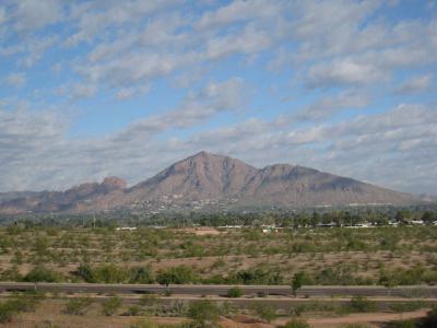


Camelback Mountain, Phoenix (must see)
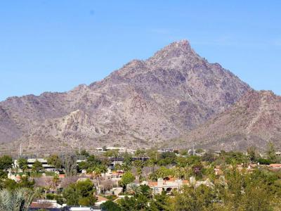
Camelback Mountain is a mountain in Phoenix. The English name is derived from its shape, which resembles the hump and head of a kneeling camel. The mountain, a prominent landmark of the Phoenix metropolitan area, is located in the Camelback Mountain Echo Canyon Recreation Area between the Arcadia neighborhood of Phoenix and the town of Paradise Valley. It is a popular recreation destination for hiking and rock climbing.
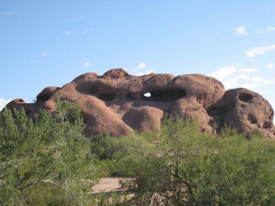
A cave discovered on the north side of Camelback Mountain indicates that it was used as a sacred site by the prehistoric Hohokam Culture before they abandoned the area in the 14th century.
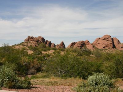
Two hiking trails ascend 1,280 feet (390 m) to the peak of Camelback Mountain. The Echo Canyon Trail is 1.14 miles (1900 m) and the Cholla Trail is 1.4 mi (2300 m). Both trails are considered strenuous with steep grades. The hiking path has dirt, gravel, boulders, and some handrail-assisted sections. The average hike requires a round trip time of 1.5 to 3 hours.
The Praying Monk is a red sandstone rock formation which is used for rock climbing. Located on the northern slope, the formation resembles the silhouette of a person kneeling in prayer. It rises approximately 100 feet (30 m) and the eastern face has several permanent anchor bolts for attaching a belay rope.
A cave discovered on the north side of Camelback Mountain indicates that it was used as a sacred site by the prehistoric Hohokam Culture before they abandoned the area in the 14th century.
Two hiking trails ascend 1,280 feet (390 m) to the peak of Camelback Mountain. The Echo Canyon Trail is 1.14 miles (1900 m) and the Cholla Trail is 1.4 mi (2300 m). Both trails are considered strenuous with steep grades. The hiking path has dirt, gravel, boulders, and some handrail-assisted sections. The average hike requires a round trip time of 1.5 to 3 hours.
The Praying Monk is a red sandstone rock formation which is used for rock climbing. Located on the northern slope, the formation resembles the silhouette of a person kneeling in prayer. It rises approximately 100 feet (30 m) and the eastern face has several permanent anchor bolts for attaching a belay rope.
Sight description based on Wikipedia.
Want to visit this sight? Check out these Self-Guided Walking Tours in Phoenix. Alternatively, you can download the mobile app "GPSmyCity: Walks in 1K+ Cities" from Apple App Store or Google Play Store. The app turns your mobile device to a personal tour guide and it works offline, so no data plan is needed when traveling abroad.
Download The GPSmyCity App
Camelback Mountain on Map
Sight Name: Camelback Mountain
Sight Location: Phoenix, USA (See walking tours in Phoenix)
Sight Type: Attraction/Landmark
Sight Location: Phoenix, USA (See walking tours in Phoenix)
Sight Type: Attraction/Landmark
Nearby Sights


Wrigley Mansion (must see)
Sight description based on Wikipedia.

Walking Tours in Phoenix, Arizona

Create Your Own Walk in Phoenix
Creating your own self-guided walk in Phoenix is easy and fun. Choose the city attractions that you want to see and a walk route map will be created just for you. You can even set your hotel as the start point of the walk.

Phoenix Introduction Walking Tour
Phoenix is the largest city in Arizona and the central city in a larger metropolitan area known as the Valley of the Sun. The city was first settled as an agricultural community where the Salt and Gila Rivers met. An intricate canal system keeps this hot corner of the Sonoran Desert fertile. In the early days, the city's economy was based on the "Five Cs"-citrus, cotton, copper,... view more
Tour Duration: 2 Hour(s)
Travel Distance: 3.7 Km or 2.3 Miles
Tour Duration: 2 Hour(s)
Travel Distance: 3.7 Km or 2.3 Miles

Downtown Historical Landmarks Walking Tour
The downtown area of Phoenix, Arizona, is loaded with notable sites, each bearing witness to a unique chapter in the city's past, from the Victorian elegance of the Rosson House Museum to the spiritual grandeur of Saint Mary's Basilica and the cinematic allure of the Barrister Building.
The latter, known as "The Psycho" Building, gained fame for its cameo in Alfred... view more
Tour Duration: 2 Hour(s)
Travel Distance: 3.9 Km or 2.4 Miles
The latter, known as "The Psycho" Building, gained fame for its cameo in Alfred... view more
Tour Duration: 2 Hour(s)
Travel Distance: 3.9 Km or 2.4 Miles

Arizona State University (ASU) Walking Tour
Founded in 1885 by the 13th Arizona Territorial Legislature, Arizona State University (ASU) is one of the largest public universities by enrollment in the United States. ASU has nearly 150,000 students attending classes across its five campuses and four regional learning centers throughout the state.
The university's main campus at Tempe Arizona, east of downtown Phoenix, is an attraction... view more
Tour Duration: 2 Hour(s)
Travel Distance: 3.6 Km or 2.2 Miles
The university's main campus at Tempe Arizona, east of downtown Phoenix, is an attraction... view more
Tour Duration: 2 Hour(s)
Travel Distance: 3.6 Km or 2.2 Miles