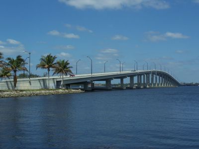


Edison Bridge, Fort Myers
The Edison Bridge in Fort Myers consists of two separate three-lane bridges that carry U.S. Highway 41 Business across the Caloosahatchee River. One span handles northbound traffic and the other southbound, linking downtown Fort Myers with North Fort Myers. At 55 feet high, the bridges allow uninterrupted boat traffic and eliminate the need for a drawbridge. Though both spans meet at a single point on the river’s north shore, they are separated by several blocks on the south side, forming a right triangle when viewed on a map.
The current dual-span configuration was completed in the early 1990s, replacing the original Edison Bridge, a two-lane drawbridge that dated back to 1931. That original bridge was named in honor of inventor Thomas Edison, who had a winter home in Fort Myers and personally dedicated the bridge on his 84th birthday by driving across it. The bridge initially carried the Tamiami Trail (U.S. 41), serving as a major regional route until the Caloosahatchee Bridge opened downstream in 1964, shifting U.S. 41 traffic away from the city center.
Before the Edison Bridge, the Caloosahatchee River was crossed by the East End Bridge, a wooden and iron swing-span structure at Freemont Street that opened in 1924. Originally started as a toll bridge by a private company, it was completed by Lee County to qualify for inclusion in the U.S. Highway system. Deemed too narrow and poorly situated, it served only as a temporary crossing and was eventually repurposed as a fishing pier before being dismantled by fire in 1940.
Although no longer carrying the main U.S. 41 route, the Edison Bridge remains part of the Tamiami Trail through its business designation. Its design mirrors other regional bridges like the Barron Collier and Gilchrist Bridges over the Peace River. Today, it serves as both a transportation link and a local landmark, reflecting the area’s evolving infrastructure and Edison's historical legacy.
Want to visit this sight? Check out these Self-Guided Walking Tours in Fort Myers. Alternatively, you can download the mobile app "GPSmyCity: Walks in 1K+ Cities" from Apple App Store or Google Play Store. The app turns your mobile device to a personal tour guide and it works offline, so no data plan is needed when traveling abroad.
Download The GPSmyCity App
Edison Bridge on Map
Sight Name: Edison Bridge
Sight Location: Fort Myers, USA (See walking tours in Fort Myers)
Sight Type: Attraction/Landmark
Sight Location: Fort Myers, USA (See walking tours in Fort Myers)
Sight Type: Attraction/Landmark
Nearby Sights


Walking Tours in Fort Myers, Florida

Create Your Own Walk in Fort Myers
Creating your own self-guided walk in Fort Myers is easy and fun. Choose the city attractions that you want to see and a walk route map will be created just for you. You can even set your hotel as the start point of the walk.
Fort Myers Downtown Walking Tour
Fort Myers has long attracted people looking for a straightforward place to work, think, or spend time in warm weather. Thomas Edison and Henry Ford were among the most well-known winter residents, spending seasons along the Caloosahatchee River where they worked on projects, met with friends, and followed steady routines.
The name “Fort Myers” dates back to the mid-1800s, when a U.S. Army... view more
Tour Duration: 2 Hour(s)
Travel Distance: 2.8 Km or 1.7 Miles
The name “Fort Myers” dates back to the mid-1800s, when a U.S. Army... view more
Tour Duration: 2 Hour(s)
Travel Distance: 2.8 Km or 1.7 Miles