

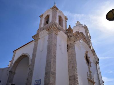
Forte da Ponta da Bandeira (Flag's Mast Fort), Lagos (must see)
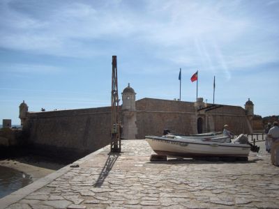
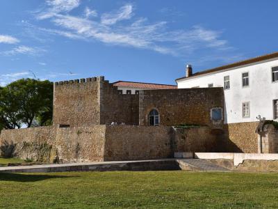
Flag’s Mast Fort stands at the mouth of the Bensafrim River, in full view of the Atlantic, guarding the narrow entrance to Lagos harbour. Built in the late 17th century and completed in 1690, the fort reflects the strategic importance of Lagos at a time when the Algarve coast was frequently targeted by pirates and corsairs. Lagos then served as the seat of the military government of the Algarve, making strong coastal defences a priority following the restoration of Portuguese independence from Spain.
Positioned to control both river and sea access, the fort was designed to protect the docks and quays along the riverbanks while establishing effective crossfire with the redoubts of Lagos Castle and the city gates. Upon completion, it was considered one of the most effective defensive structures in the region.
Built on a square plan, the fort features thick stone walls, corner turrets, and firing platforms carefully arranged to cover approaching ships and potential landings. A narrow drawbridge once connected it to the shore. Its name derives from the flag mast that flew signals to announce arrivals and warn of danger.
Today, access to the fort is gained via a permanent stone bridge followed by a wooden drawbridge. Although the drawbridge mechanism is no longer operational, it remains one of the few surviving examples of its kind in the region. Looking down, you can also observe the dry moat that surrounds the fort, designed to prevent land-based attacks.
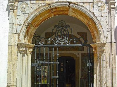
As you enter the fort and face the ramp leading to the terrace, an arched doorway appears in the far-right corner. Behind it lies a small chapel dedicated to Saint Barbara, the patron saint of armourers, artillery soldiers, and miners. The chapel’s walls are lined with traditional blue azulejo tiles.
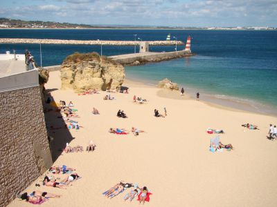
Finally, following the ramp upward brings you to the fort’s terrace. From here, views extend in all directions, encompassing Meia Praia Beach, the historic city walls, and the entrance to Lagos Marina. At each of the four corners of the fort stand small cylindrical lookout towers capped with conical roofs, once used by sentries to watch for approaching ships or pirate vessels.
Positioned to control both river and sea access, the fort was designed to protect the docks and quays along the riverbanks while establishing effective crossfire with the redoubts of Lagos Castle and the city gates. Upon completion, it was considered one of the most effective defensive structures in the region.
Built on a square plan, the fort features thick stone walls, corner turrets, and firing platforms carefully arranged to cover approaching ships and potential landings. A narrow drawbridge once connected it to the shore. Its name derives from the flag mast that flew signals to announce arrivals and warn of danger.
Today, access to the fort is gained via a permanent stone bridge followed by a wooden drawbridge. Although the drawbridge mechanism is no longer operational, it remains one of the few surviving examples of its kind in the region. Looking down, you can also observe the dry moat that surrounds the fort, designed to prevent land-based attacks.
As you enter the fort and face the ramp leading to the terrace, an arched doorway appears in the far-right corner. Behind it lies a small chapel dedicated to Saint Barbara, the patron saint of armourers, artillery soldiers, and miners. The chapel’s walls are lined with traditional blue azulejo tiles.
Finally, following the ramp upward brings you to the fort’s terrace. From here, views extend in all directions, encompassing Meia Praia Beach, the historic city walls, and the entrance to Lagos Marina. At each of the four corners of the fort stand small cylindrical lookout towers capped with conical roofs, once used by sentries to watch for approaching ships or pirate vessels.
Want to visit this sight? Check out these Self-Guided Walking Tours in Lagos. Alternatively, you can download the mobile app "GPSmyCity: Walks in 1K+ Cities" from Apple App Store or Google Play Store. The app turns your mobile device to a personal tour guide and it works offline, so no data plan is needed when traveling abroad.
Download The GPSmyCity App
Forte da Ponta da Bandeira (Flag's Mast Fort) on Map
Sight Name: Forte da Ponta da Bandeira (Flag's Mast Fort)
Sight Location: Lagos, Portugal (See walking tours in Lagos)
Sight Type: Attraction/Landmark
Guide(s) Containing This Sight:
Sight Location: Lagos, Portugal (See walking tours in Lagos)
Sight Type: Attraction/Landmark
Guide(s) Containing This Sight:
Nearby Sights
Walking Tours in Lagos, Portugal

Create Your Own Walk in Lagos
Creating your own self-guided walk in Lagos is easy and fun. Choose the city attractions that you want to see and a walk route map will be created just for you. You can even set your hotel as the start point of the walk.
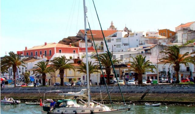
Lagos Coastline Walk
Lagos’s coastline has shaped the town’s character as much as its streets and walls, acting for centuries as both gateway and boundary. The natural harbour formed by the Bensafrim River and the chain of rocky headlands to the east created a sheltered maritime zone that defined how the town engaged with the Atlantic ocean.
For much of its history, the coastline was a working landscape. Under... view more
Tour Duration: 2 Hour(s)
Travel Distance: 3.6 Km or 2.2 Miles
For much of its history, the coastline was a working landscape. Under... view more
Tour Duration: 2 Hour(s)
Travel Distance: 3.6 Km or 2.2 Miles
Lagos Introduction Walking Tour
Lagos is one of the oldest towns in the Algarve, with a history shaped by its coastal position, maritime activity, and strategic value. Its name is commonly traced to the Latin Lacobriga, itself likely derived from earlier Celtic roots: lac, meaning “lake” or “lagoon,” and briga, meaning “fortified place” or “hill settlement.”
The settlement’s story stretches back over two... view more
Tour Duration: 2 Hour(s)
Travel Distance: 2.6 Km or 1.6 Miles
The settlement’s story stretches back over two... view more
Tour Duration: 2 Hour(s)
Travel Distance: 2.6 Km or 1.6 Miles