

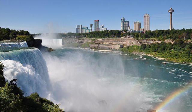
Horseshoe Falls, Niagara Falls
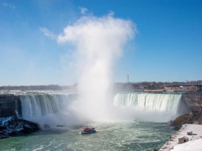
Horseshoe Falls is the largest and most iconic of the three waterfalls that together make up Niagara Falls, straddling the border between Canada and the United States. Also known as the Canadian Falls, this colossal curtain of water carries about 90% of the Niagara River's flow-after diversions for hydroelectric power-making it the true powerhouse of the trio, alongside the American Falls and Bridal Veil Falls.
The Falls curve majestically between Terrapin Point on Goat Island in New York and Table Rock in Ontario, creating the familiar horseshoe shape that gives the falls its name. Though now mostly situated in Canada, Horseshoe Falls wasn’t always so neatly defined. When the US–Canada boundary was agreed upon in 1819, the northeastern edge of the falls lay in New York. Over time, a series of land alterations-including the creation of Terrapin Point in 1955 and further modifications by the U.S. Army Corps of Engineers in the 1980s-have shifted the layout, shaving off around 400 feet (120 meters) from the original span of the falls.
Despite these changes, Horseshoe Falls continues to evolve, as natural erosion slowly alters its shape and potentially its international boundaries. Today, official maps show that a small portion of the falls still lies within the United States, though the overwhelming view and experience of its thunderous power is best enjoyed from the Canadian side.
Want to visit this sight? Check out these Self-Guided Walking Tours in Niagara Falls. Alternatively, you can download the mobile app "GPSmyCity: Walks in 1K+ Cities" from Apple App Store or Google Play Store. The app turns your mobile device to a personal tour guide and it works offline, so no data plan is needed when traveling abroad.
Download The GPSmyCity App
Horseshoe Falls on Map
Sight Name: Horseshoe Falls
Sight Location: Niagara Falls, Canada (See walking tours in Niagara Falls)
Sight Type: Attraction/Landmark
Sight Location: Niagara Falls, Canada (See walking tours in Niagara Falls)
Sight Type: Attraction/Landmark
Nearby Sights


Walking Tours in Niagara Falls, Ontario

Create Your Own Walk in Niagara Falls
Creating your own self-guided walk in Niagara Falls is easy and fun. Choose the city attractions that you want to see and a walk route map will be created just for you. You can even set your hotel as the start point of the walk.
Niagara Falls Introduction Walking Tour
Niagara Falls, Ontario, is a Canadian twin of the U.S. city by the same name, located in Niagara County, New York, just across the Niagara River spanned by the Rainbow Bridge. The two cities are named for the same world-famous Niagara Falls, one of the most extreme, awe-inspiring waterfalls on earth.
The area of Niagara Falls was originally named "Ongiara", after the indigenous... view more
Tour Duration: 2 Hour(s)
Travel Distance: 3.3 Km or 2.1 Miles
The area of Niagara Falls was originally named "Ongiara", after the indigenous... view more
Tour Duration: 2 Hour(s)
Travel Distance: 3.3 Km or 2.1 Miles
Niagara Falls Historical Buildings
Despite being a small town, Niagara Falls, Ontario, is home to several significant pieces of historical architecture reflecting the city's unique character and heritage. Indeed, from the grand Gothic-Revival Railway Station to the charming Queen Anne-style Doran-Marshall Residence, the old buildings of Niagara Falls offer a colorful display of masonry craftsmanship whose intricate carvings,... view more
Tour Duration: 1 Hour(s)
Travel Distance: 1.9 Km or 1.2 Miles
Tour Duration: 1 Hour(s)
Travel Distance: 1.9 Km or 1.2 Miles