

Hubbard Park, Montpelier
Hubbard Park is one of Montpelier’s defining green spaces, a broad stretch of woodland rising just behind the Vermont State House and offering a quiet contrast to the compact capital below. Established in 1899, the park began with a gift of more than 130 acres from philanthropist John Erastus Hubbard, who intended the land to “preserve wilderness” for future generations. Over time, additional parcels expanded the park to over 200 acres, shaping it into a central recreational landscape woven into the city itself.
From the outset, the park was designed to follow the natural terrain rather than impose rigid geometry. Landscape architect Dana F. Dow mapped out winding roads and paths that adapt to the hills, reinforcing the sense that this is a managed forest rather than a formal garden. Today, that approach remains evident in the park’s network of roughly seven miles of trails, used year-round for walking, hiking, and cross-country skiing. Meadows, pine stands, hardwood groves, and small wetlands create a varied natural environment, with occasional clearings revealing views back toward the gold dome of the State House.
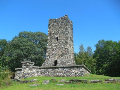
The park’s defining feature is its stone observation tower, built between 1915 and 1930 at the hill’s highest point. Made from local stone, it rises above the trees and offers wide views of the surrounding valleys and mountains, with a rugged, historic character that invites visitors to climb and pause.
Beyond the tower, Hubbard Park combines its natural setting with simple amenities, including picnic areas, open fields, a pond, and a sledding hill. Over time, improvements—many from the New Deal era—were added with care, enhancing access while preserving the park’s overall character.
From the outset, the park was designed to follow the natural terrain rather than impose rigid geometry. Landscape architect Dana F. Dow mapped out winding roads and paths that adapt to the hills, reinforcing the sense that this is a managed forest rather than a formal garden. Today, that approach remains evident in the park’s network of roughly seven miles of trails, used year-round for walking, hiking, and cross-country skiing. Meadows, pine stands, hardwood groves, and small wetlands create a varied natural environment, with occasional clearings revealing views back toward the gold dome of the State House.
The park’s defining feature is its stone observation tower, built between 1915 and 1930 at the hill’s highest point. Made from local stone, it rises above the trees and offers wide views of the surrounding valleys and mountains, with a rugged, historic character that invites visitors to climb and pause.
Beyond the tower, Hubbard Park combines its natural setting with simple amenities, including picnic areas, open fields, a pond, and a sledding hill. Over time, improvements—many from the New Deal era—were added with care, enhancing access while preserving the park’s overall character.
Want to visit this sight? Check out these Self-Guided Walking Tours in Montpelier. Alternatively, you can download the mobile app "GPSmyCity: Walks in 1K+ Cities" from Apple App Store or Google Play Store. The app turns your mobile device to a personal tour guide and it works offline, so no data plan is needed when traveling abroad.
Download The GPSmyCity App
Hubbard Park on Map
Sight Name: Hubbard Park
Sight Location: Montpelier, USA (See walking tours in Montpelier)
Sight Type: Park/Outdoor
Sight Location: Montpelier, USA (See walking tours in Montpelier)
Sight Type: Park/Outdoor
Nearby Sights


Walking Tours in Montpelier, Vermont

Create Your Own Walk in Montpelier
Creating your own self-guided walk in Montpelier is easy and fun. Choose the city attractions that you want to see and a walk route map will be created just for you. You can even set your hotel as the start point of the walk.
Montpelier Introduction Walking Tour
Montpelier, the capital of Vermont, traces its origins to the late 18th century, when settlers began arriving in the area following the American Revolution. The land, originally inhabited by Indigenous peoples, including the Abenaki, became part of a wave of new town charters issued as Vermont transitioned from contested territory into an independent republic and, eventually, the 14th U.S. state... view more
Tour Duration: 1 Hour(s)
Travel Distance: 1.6 Km or 1 Miles
Tour Duration: 1 Hour(s)
Travel Distance: 1.6 Km or 1 Miles