

Audio Guide: Montpelier Introduction Walking Tour (Self Guided), Montpelier
Montpelier, the capital of Vermont, traces its origins to the late 18th century, when settlers began arriving in the area following the American Revolution. The land, originally inhabited by Indigenous peoples, including the Abenaki, became part of a wave of new town charters issued as Vermont transitioned from contested territory into an independent republic and, eventually, the 14th U.S. state in 1791.
The city’s name, “Montpelier,” is believed to have been inspired by Montpellier in southern France. It was chosen by Colonel Jacob Davis, an early settler and influential figure in the town’s development, who is said to have admired French culture and possibly wished to reflect the young nation’s alliance with France during the Revolutionary War. The name itself derives from the French mont pelé, meaning “bare hill,” likely referencing the open, treeless slopes that characterized the landscape at the time.
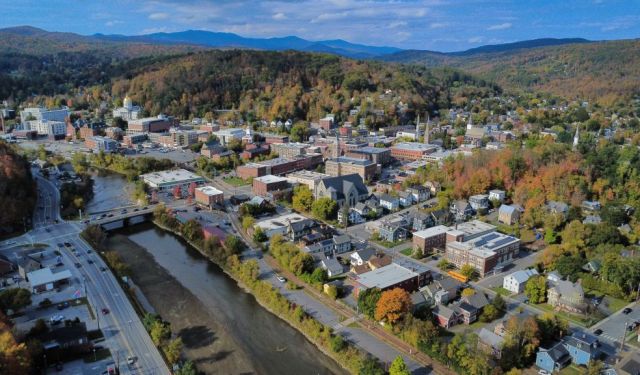
Montpelier developed at the meeting point of the Winooski River and its tributaries, a location that naturally supported milling and small-scale industry. In the early 19th century, it grew steadily as a commercial and administrative centre. In 1805, Montpelier was selected as the state capital, partly due to its central location and accessibility within Vermont’s largely rural geography.
Unlike many American capitals, Montpelier remained small in scale. It never industrialized heavily, and its growth was shaped more by government activity, local commerce, and community institutions than by large factories. The arrival of the railroad in the mid-19th century improved connections to other parts of New England, supporting trade and movement without dramatically altering the city’s character.
Throughout the 20th century, Montpelier maintained its identity as a compact administrative centre, with a focus on public service, education, and local enterprise.
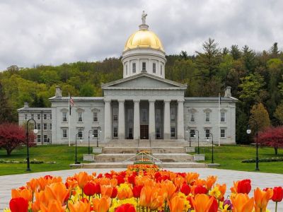
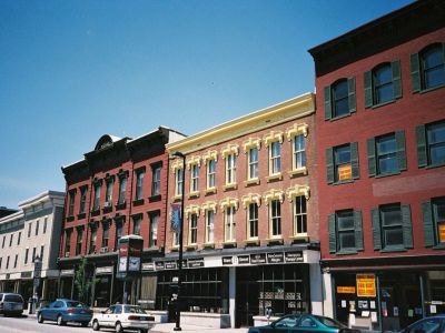
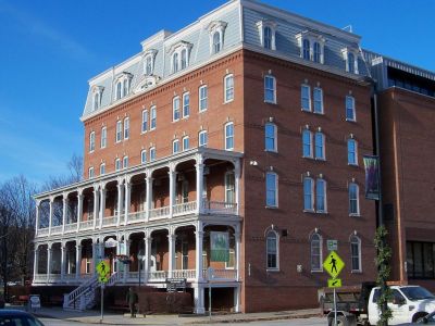
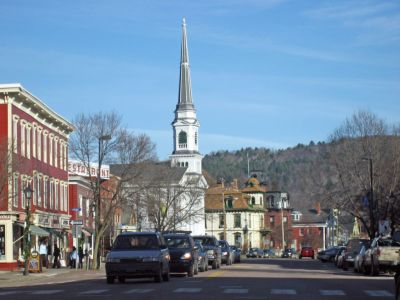
Walking through downtown Montpelier, visitors move along compact streets lined with 19th-century buildings housing independent shops, bookstores, cafés, and galleries. State Street leads toward the Vermont State House, its gold dome visible above the treetops, while Main Street offers a steady rhythm of local businesses and everyday activity. Along the Winooski River, small bridges and quiet corners provide contrast to the civic centre, creating a setting that feels both active and unhurried.
Today, Montpelier stands out as the smallest state capital in the United States by population. Yet, that is not a drawback—quite the opposite. Step into its centre, and you may find that this small capital offers far more than it first seems.
The city’s name, “Montpelier,” is believed to have been inspired by Montpellier in southern France. It was chosen by Colonel Jacob Davis, an early settler and influential figure in the town’s development, who is said to have admired French culture and possibly wished to reflect the young nation’s alliance with France during the Revolutionary War. The name itself derives from the French mont pelé, meaning “bare hill,” likely referencing the open, treeless slopes that characterized the landscape at the time.
Montpelier developed at the meeting point of the Winooski River and its tributaries, a location that naturally supported milling and small-scale industry. In the early 19th century, it grew steadily as a commercial and administrative centre. In 1805, Montpelier was selected as the state capital, partly due to its central location and accessibility within Vermont’s largely rural geography.
Unlike many American capitals, Montpelier remained small in scale. It never industrialized heavily, and its growth was shaped more by government activity, local commerce, and community institutions than by large factories. The arrival of the railroad in the mid-19th century improved connections to other parts of New England, supporting trade and movement without dramatically altering the city’s character.
Throughout the 20th century, Montpelier maintained its identity as a compact administrative centre, with a focus on public service, education, and local enterprise.
Walking through downtown Montpelier, visitors move along compact streets lined with 19th-century buildings housing independent shops, bookstores, cafés, and galleries. State Street leads toward the Vermont State House, its gold dome visible above the treetops, while Main Street offers a steady rhythm of local businesses and everyday activity. Along the Winooski River, small bridges and quiet corners provide contrast to the civic centre, creating a setting that feels both active and unhurried.
Today, Montpelier stands out as the smallest state capital in the United States by population. Yet, that is not a drawback—quite the opposite. Step into its centre, and you may find that this small capital offers far more than it first seems.
How it works: Download the app "GPSmyCity: Walks in 1K+ Cities" from Apple App Store or Google Play Store to your mobile phone or tablet. The app turns your mobile device into a personal tour guide and its built-in GPS navigation functions guide you from one tour stop to next. The app works offline, so no data plan is needed when traveling abroad.
Download The GPSmyCity App
Montpelier Introduction Walking Tour Map
Guide Name: Montpelier Introduction Walking Tour
Guide Location: USA » Montpelier (See other walking tours in Montpelier)
Guide Type: Self-guided Walking Tour (Sightseeing)
Tour Duration: 1 Hour(s)
Travel Distance: 1.6 Km or 1 Miles
Guide Location: USA » Montpelier (See other walking tours in Montpelier)
Guide Type: Self-guided Walking Tour (Sightseeing)
Tour Duration: 1 Hour(s)
Travel Distance: 1.6 Km or 1 Miles
Sights Featured in This Walk


The Most Popular Cities
/ view all