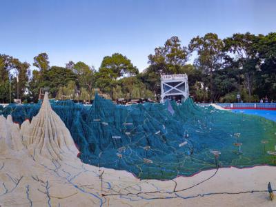


Mapa en Relieve de Guatemala (Relief Map of Guatemala), Guatemala City
The Relief Map of Guatemala is an extraordinary open-air museum and engineering marvel that offers a bird’s-eye view of the nation’s varied landscape. Spanning an impressive 1,800 m² and crafted at scales of 1:10,000 horizontally and 1:2,000 vertically, it dramatizes terrain features-from volcanic peaks and canyons to rivers, lakes, and cities-with exaggerated depth that makes its fold-and-rise topography come vividly to life.
Commissioned by President Manuel Estrada Cabrera and built between 1904 and 1905, the map was designed under the supervision of engineer Francisco Vela. The monumental structure-with brick-lined level contours, steel bridges, and lead railway lines-was fueled by extensive field surveys across the country, undertaken on foot, horseback, and by donkey over a 15-year period . Remarkably, it operates with real water features: lakes and rivers flow using communicating-vessel principles powered by an underground reservoir.
Today, the map still dazzles visitors with its scale and detail. Two observation towers offer panoramic vantage points to appreciate Guatemala's mountainous backbone, including active volcanoes and lush lowlands. Educational plaques, a small exhibition hall showcasing 18th-century photos, and the adjacent “Sonorous Forest”-a garden of hormigo trees planted in honor of marimba composers-round out a visit that blends geography, history, and botany.
Want to visit this sight? Check out these Self-Guided Walking Tours in Guatemala City. Alternatively, you can download the mobile app "GPSmyCity: Walks in 1K+ Cities" from Apple App Store or Google Play Store. The app turns your mobile device to a personal tour guide and it works offline, so no data plan is needed when traveling abroad.
Download The GPSmyCity App
Mapa en Relieve de Guatemala (Relief Map of Guatemala) on Map
Sight Name: Mapa en Relieve de Guatemala (Relief Map of Guatemala)
Sight Location: Guatemala City, Guatemala (See walking tours in Guatemala City)
Sight Type: Attraction/Landmark
Sight Location: Guatemala City, Guatemala (See walking tours in Guatemala City)
Sight Type: Attraction/Landmark
Walking Tours in Guatemala City, Guatemala

Create Your Own Walk in Guatemala City
Creating your own self-guided walk in Guatemala City is easy and fun. Choose the city attractions that you want to see and a walk route map will be created just for you. You can even set your hotel as the start point of the walk.
Religious Buildings Walk
Guatemala City's religious scene, while also embracing other faiths, is centered predominantly around Catholicism. The local churches are quite impressive in terms of architecture and are an integral part of the local culture and everyday life. Nestled amid the city's bustling streets and modern architecture, the multiple sacred sites reflect the deep spiritual roots of the Guatemalan... view more
Tour Duration: 1 Hour(s)
Travel Distance: 2.4 Km or 1.5 Miles
Tour Duration: 1 Hour(s)
Travel Distance: 2.4 Km or 1.5 Miles
Guatemala City Culture Venues
Among other things that a tourist may find interesting in Guatemala City are a number of cultural venues, such as museums, that provide an opportunity to discover some important and sometimes curious historical artifacts about the capital of Guatemala.
One such venue is the Guatemala City Railway Museum, located within the former railway station, offering thrilling exhibitions and a wealth of... view more
Tour Duration: 1 Hour(s)
Travel Distance: 1.7 Km or 1.1 Miles
One such venue is the Guatemala City Railway Museum, located within the former railway station, offering thrilling exhibitions and a wealth of... view more
Tour Duration: 1 Hour(s)
Travel Distance: 1.7 Km or 1.1 Miles
Guatemala City Introduction Walking Tour
Guatemala City is the capital city of Guatemala and the largest city in Central America. The history of the city dates to 1500 BC when the land was part of the Mayan civilization. The city was known as Kaminaljuyu, which collapsed for unknown causes around 300 AD.
Guatemala City as it stands today was established in 1776 following the Spanish conquest as the capital of the Kingdom of Guatemala.... view more
Tour Duration: 2 Hour(s)
Travel Distance: 3.0 Km or 1.9 Miles
Guatemala City as it stands today was established in 1776 following the Spanish conquest as the capital of the Kingdom of Guatemala.... view more
Tour Duration: 2 Hour(s)
Travel Distance: 3.0 Km or 1.9 Miles