

The Strip, Las Vegas (must see)
The Las Vegas Strip, located in Clark County, Nevada, is a renowned section of Las Vegas Boulevard known for its concentration of resort hotels and casinos. Stretching approximately 4.2 miles (6.8 kilometers), it lies immediately south of the Las Vegas city limits in the unincorporated towns of Paradise and Winchester, often simply referred to as "Las Vegas."
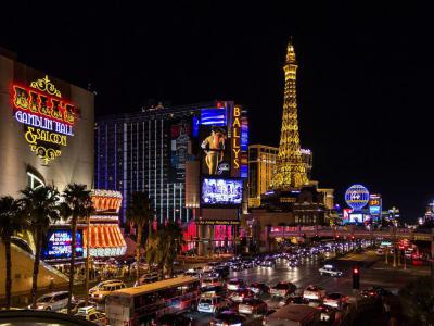
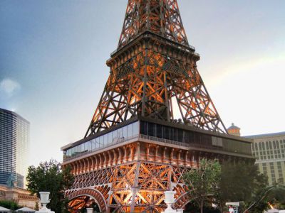
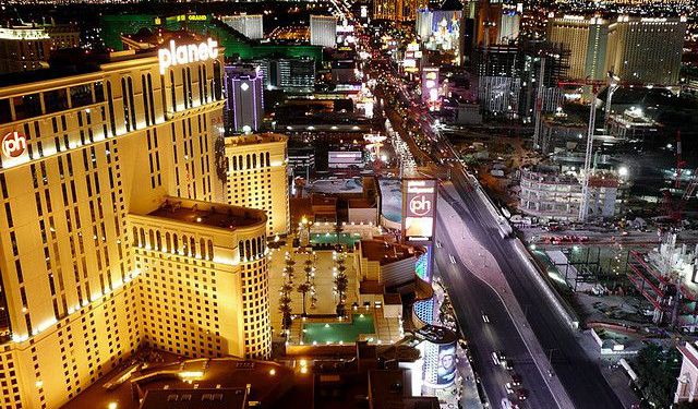
The Strip boasts some of the world's largest hotel, casino, and resort properties, featuring contemporary architecture, dazzling lights, and a wide array of attractions. Its hotels, casinos, restaurants, residential high-rises, entertainment offerings, and distinctive skyline have firmly established it as a globally popular and iconic tourist destination, playing a vital role in driving Las Vegas's economy. Most of the Strip has been designated as an All-American Road, while the North and South Las Vegas Strip routes are classified as Nevada Scenic Byways and National Scenic Byways.
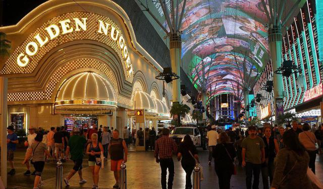
In the past, casinos outside Downtown Las Vegas along Fremont Street were situated beyond the city limits on Las Vegas Boulevard. In 1959, the Welcome to Fabulous Las Vegas sign was erected precisely 4.5 miles (7.2 kilometers) outside the city boundaries. Currently, the sign is located in the median just south of Russell Road, across from the former site of the now-demolished Klondike Hotel and Casino, and around 0.4 miles (0.64 kilometers) south of the southernmost entrance to Mandalay Bay, which stands as the Strip's southernmost casino.
Strictly speaking, "the Strip" specifically refers to the portion of Las Vegas Boulevard between Sahara Avenue and Russell Road, spanning a distance of 4.2 miles (6.8 kilometers). However, Clark County employs the term "Resort Corridor" to describe the wider area encompassing Las Vegas Boulevard between the 215 Beltway and Sahara Avenue, along with the surrounding regions.
Traditionally, the Sahara is widely acknowledged as the northern end of the Strip, although travel guides often extend it to the Strat, situated 0.4 miles (0.64 kilometers) further north. Mandalay Bay, positioned just north of Russell Road, is considered the southernmost resort on the Strip.
The Strip boasts some of the world's largest hotel, casino, and resort properties, featuring contemporary architecture, dazzling lights, and a wide array of attractions. Its hotels, casinos, restaurants, residential high-rises, entertainment offerings, and distinctive skyline have firmly established it as a globally popular and iconic tourist destination, playing a vital role in driving Las Vegas's economy. Most of the Strip has been designated as an All-American Road, while the North and South Las Vegas Strip routes are classified as Nevada Scenic Byways and National Scenic Byways.
In the past, casinos outside Downtown Las Vegas along Fremont Street were situated beyond the city limits on Las Vegas Boulevard. In 1959, the Welcome to Fabulous Las Vegas sign was erected precisely 4.5 miles (7.2 kilometers) outside the city boundaries. Currently, the sign is located in the median just south of Russell Road, across from the former site of the now-demolished Klondike Hotel and Casino, and around 0.4 miles (0.64 kilometers) south of the southernmost entrance to Mandalay Bay, which stands as the Strip's southernmost casino.
Strictly speaking, "the Strip" specifically refers to the portion of Las Vegas Boulevard between Sahara Avenue and Russell Road, spanning a distance of 4.2 miles (6.8 kilometers). However, Clark County employs the term "Resort Corridor" to describe the wider area encompassing Las Vegas Boulevard between the 215 Beltway and Sahara Avenue, along with the surrounding regions.
Traditionally, the Sahara is widely acknowledged as the northern end of the Strip, although travel guides often extend it to the Strat, situated 0.4 miles (0.64 kilometers) further north. Mandalay Bay, positioned just north of Russell Road, is considered the southernmost resort on the Strip.
Want to visit this sight? Check out these Self-Guided Walking Tours in Las Vegas. Alternatively, you can download the mobile app "GPSmyCity: Walks in 1K+ Cities" from Apple App Store or Google Play Store. The app turns your mobile device to a personal tour guide and it works offline, so no data plan is needed when traveling abroad.
Download The GPSmyCity App
The Strip on Map
Sight Name: The Strip
Sight Location: Las Vegas, USA (See walking tours in Las Vegas)
Sight Type: Attraction/Landmark
Sight Location: Las Vegas, USA (See walking tours in Las Vegas)
Sight Type: Attraction/Landmark
Nearby Sights


Walking Tours in Las Vegas, Nevada

Create Your Own Walk in Las Vegas
Creating your own self-guided walk in Las Vegas is easy and fun. Choose the city attractions that you want to see and a walk route map will be created just for you. You can even set your hotel as the start point of the walk.
Gangster Attractions Walking Tour
The development of Las Vegas as a gambling and entertainment hub in the mid-20th century drew the attention of powerful criminal syndicates, who saw the potential for profit in the city's casinos and other enterprises. Indeed, Las Vegas with its glitz and glamour wouldn't be what it is now without the involvement of mobster “wiseguys”. There are still a few places in town that evoke... view more
Tour Duration: 3 Hour(s)
Travel Distance: 8.1 Km or 5 Miles
Tour Duration: 3 Hour(s)
Travel Distance: 8.1 Km or 5 Miles
Downtown Walking Tour
Las Vegas began not as a gambling capital, but as a modest desert settlement shaped by transportation and opportunity. The turning point came in 1905 with the arrival of the San Pedro, Los Angeles and Salt Lake Railroad, which transformed a remote oasis into a service town for workers, traders, and travelers crossing the Mojave Desert. Officially incorporated in 1911, the city’s early life... view more
Tour Duration: 1 Hour(s)
Travel Distance: 2.1 Km or 1.3 Miles
Tour Duration: 1 Hour(s)
Travel Distance: 2.1 Km or 1.3 Miles
Las Vegas Boulevard Walking Tour
“What happens in Las Vegas, stays in Las Vegas.”
Las Vegas began as a desert oasis long before it became synonymous with neon lights and casinos. The area was originally inhabited by Southern Paiute peoples, who relied on natural artesian springs that surfaced in what is now the Las Vegas Valley. The name Las Vegas comes from Spanish and means “the meadows”. It was given in 1829 by... view more
Tour Duration: 2 Hour(s)
Travel Distance: 3.4 Km or 2.1 Miles
Useful Travel Guides for Planning Your Trip
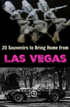
20 Souvenirs to Bring Home from Las Vegas
You may have kept on the run, had some fun in Las Vegas and, unless it cost you the very last dime, you might want to pick up something memorable to bring home, other than a handful of uncashed casino chips. In fact, you might as well be surprised to know there is something else in Vegas, apart from...
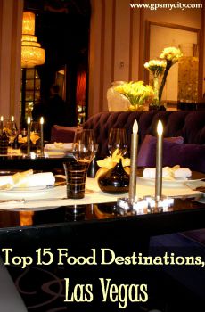
13 Best Food Destinations in Las Vegas
Las Vegas has a long-standing history of great restaurants. The city has grown so fast in the last decades, seeing many celebrity chefs in the world of culinary setting up multiple craft food establishments in either mega-resort hotels or private entities off-the-Strip, that now it is practically...
Top 18 Buffets in Las Vegas
In 1941, Thomas Hull, the man behind the Strip’s first hotel the El Rancho Vegas, realized that even though he might lose a few dollars by offering an “all you can eat” buffet,” the reward of funneling thousands of hungry gamblers through his casino to get to the buffet would more than pay...