Custom Walk in Nassau, Bahamas by sommersdawn8439 created on 2025-11-05
Guide Location: Bahamas » Nassau
Guide Type: Custom Walk
# of Sights: 8
Tour Duration: 2 Hour(s)
Travel Distance: 3 Km or 1.9 Miles
Share Key: BRQYK
Guide Type: Custom Walk
# of Sights: 8
Tour Duration: 2 Hour(s)
Travel Distance: 3 Km or 1.9 Miles
Share Key: BRQYK
How It Works
Please retrieve this walk in the GPSmyCity app. Once done, the app will guide you from one tour stop to the next as if you had a personal tour guide. If you created the walk on this website or come to the page via a link, please follow the instructions below to retrieve the walk in the app.
Retrieve This Walk in App
Step 1. Download the app "GPSmyCity: Walks in 1K+ Cities" on Apple App Store or Google Play Store.
Step 2. In the GPSmyCity app, download(or launch) the guide "Nassau Map and Walking Tours".
Step 3. Tap the menu button located at upper right corner of the "Walks" screen and select "Retrieve custom walk". Enter the share key: BRQYK
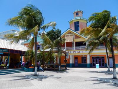
1) Prince George Wharf
Prince George Wharf is the main cruise port of The Bahamas and one of the busiest cruise gateways in the Caribbean. Large cruise liners berth directly along the downtown waterfront. Following a major redevelopment completed in 2023, the port significantly expanded its berthing capacity and visitor infrastructure, accommodating multiple megaships simultaneously and handling several million cruise passengers annually in peak years.
Passenger arrivals now pass through the Nassau Cruise Port terminal complex, which replaced the former “Festival Place” branding. The terminal combines arrival halls with retail zones designed to manage high passenger volumes efficiently. Dozens of vendor stalls and shops offer resort wear, souvenirs, and locally made crafts, including straw goods, textiles, paintings, and small decorative items associated with Bahamian visual culture.
The wharf functions as a practical starting point for short excursions and services. Nearby operators arrange activities such as horse-drawn carriage rides, scooter rentals, boat trips, and hair-braiding, many catering specifically to cruise schedules. On busy port days, live Bahamian music and informal performances are often staged within the terminal area, reinforcing the waterfront’s active, transit-oriented atmosphere.
Adjacent to the terminals, Woodes Rogers Walk offers an elevated viewpoint overlooking the harbor. From here, visitors can observe the constant movement of ships and passengers along a stretch of waterfront that has shaped Nassau’s maritime role for centuries.
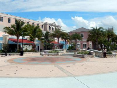
2) Pompey Square
Pompey Square is a lively and vibrant square named after the slavery rebel Pompey. The square was conceptualized in 2008 as a venue where tourists could immerse themselves in the culture, music, and arts scene of the Bahamas.
One of the main events that take place at Pompey Square is the famous Miss Bahamas Pageant Costume contest. The performances of the Royal Bahamas Police Force Band are also a regular feature, which adds to the festive atmosphere. During festivals such as Christmas and New Year's, the square is bustling with activities such as the Kids' festival, Carolling, Holiday Lunch Buffet, and much more.
The square is adorned with beautiful sculptures that capture the essence of the Bahamas. Visitors can also enjoy shopping at the various shops that line the square. If you have a sweet tooth, be sure to visit The Sweet festival, which showcases mouth-watering treats. Another must-visit festival is the Goombay Festival, which celebrates the Bahamian culture through music, dance, and food.
One of the highlights of Pompey Square is the centrally located water fountain, which provides a refreshing respite on hot summer days. It's the perfect spot to sit, relax and take in the sights and sounds of the bustling square.
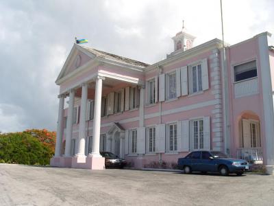
3) Government House
Government House is the official residence of the Governor-General of The Bahamas and one of Nassau’s most prominent examples of Georgian colonial architecture. The building overlooks the harbor and has long served as a symbol of colonial authority and state ceremony.
The house is painted in the traditional conch-pink color associated with Bahamian civic buildings. Its formal entrance is marked by four Ionic columns, reflecting British Georgian design principles. Elements such as wooden shutters and the use of color reflect local adaptation to climate and materials, while the overall symmetry and proportions follow British architectural conventions introduced during the Loyalist period after the American Revolutionary War.
The first Government House on this site was constructed in 1737, though the present building dates largely to 1806, following reconstruction and expansion. Over time, the residence has undergone several modifications. An east wing was added in 1909, and after hurricane damage in 1929, major repairs in the 1930s included changes to the roof, facade, and entrance.
One of the residence’s most notable occupants was Edward VIII, who served as Governor of The Bahamas from 1940 to 1945 under the title Duke of Windsor, after abdicating the British throne in 1936 to marry Wallis Simpson. During their tenure, a west wing, known as the Windsor Wing, was added. The Duchess also installed a distinctive black glass plaque on the front door, shipped from the couple’s residence in France and bearing the Duke’s Order of the Garter.
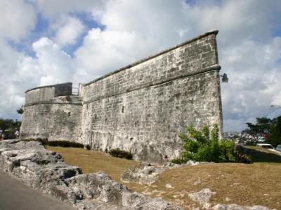
4) Fort Fincastle (must see)
Fort Fincastle was constructed in 1793 using cut limestone and occupies the summit of Bennet’s Hill, a position selected for its clear command over Nassau and the harbor. The fort was commissioned by John Murray, then Governor of The Bahamas. Most visitors arrive on foot via the historic Queen’s Staircase, which emerges at the base of the fort and leads directly into the outer grounds.
Viewed from above, the fort’s circular form is often said to resemble a paddle-wheel steamer. The structure was designed to mount approximately a dozen cannons, though there is no record of the fort ever firing its guns in combat. For a short period in the early 19th century, the fort also served as a lighthouse, before navigational duties were transferred to later harbor lights.
Once inside the fort grounds, the main viewing area is reached by walking along the outer parapet, where the low stone walls open outward toward the city and sea. Looking west, you can see the dense layout of historic downtown Nassau, with its low-rise buildings and street grid spreading outward from the harbor. Turning south, the view opens toward Nassau Harbor itself, where cruise ships and smaller vessels trace the same maritime routes once monitored by the fort’s garrison. To the east, Paradise Island comes into view across the water, its shoreline and bridges clearly visible from this elevated position.
Interpretive information panels are positioned along the inner walls and near the cannon mounts. These panels explain the fort’s construction, its relationship to other defensive sites such as Fort Charlotte and Fort Montagu, and the strategic importance of Bennet’s Hill. Together, the viewpoints and signage help visitors understand how Fort Fincastle functioned within Nassau’s wider system of coastal defenses while offering one of the clearest panoramic perspectives in the city.
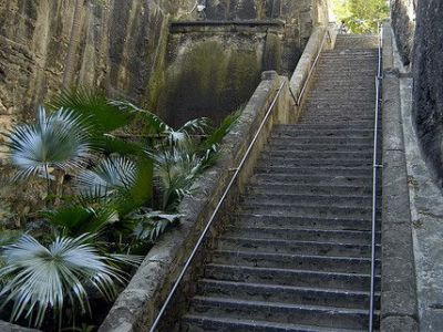
5) Queen's Staircase (must see)
Queen’s Staircase, often referred to as the 66 Steps, was hand-carved out of solid limestone in the late 18th century, most likely between 1793 and 1794, and provides a direct pedestrian route up Bennet’s Hill to Fort Fincastle. Although only 65 steps are visible today, the missing 66th step was buried during later paving works at the base of the staircase.
The staircase was created during a period when the British colony was strengthening its defenses against potential foreign threats in the Caribbean. Rather than responding specifically to pirate attacks, it formed part of a broader defensive network that included Fort Fincastle, Fort Montagu, and Fort Charlotte. Fort Fincastle stands at the highest elevation of the three, and the staircase functioned as a practical shortcut between the town below and the hilltop fortification.
The carving was carried out by enslaved Africans, using only hand tools to cut directly through the limestone cliff. One lesser-noted detail is that the chisel marks left by this work are still visible along the walls, offering a rare, tactile reminder of the labor involved. In the mid-19th century, the staircase was renamed in honor of Queen Victoria, who reigned from 1837 to 1901, reflecting the colony’s continued ties to the British Crown.
The water feature that runs alongside the staircase and the surrounding garden setting are later additions. Today, high stone walls, shade, and flowing water give the staircase a cool, grotto-like atmosphere. Although it still leads to Fort Fincastle, Queen’s Staircase is now appreciated less as a military route and more as one of Nassau’s atmospheric historic passages.
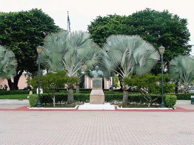
6) Rawson Square
Rawson Square has long served as one of the city’s principal civic spaces, closely tied to the development of colonial administration and public life. The square takes its name from Sir Rawson William Rawson, who governed the Bahamas between 1864 and 1869. From its early years, Rawson Square functioned as a setting for official ceremonies, public announcements, and everyday exchanges at the edge of the harbor.
The square sits at the intersection of several key institutional zones rather than being enclosed by a single architectural ensemble. To the north, it opens directly onto Bay Street, Nassau’s main commercial artery, while just across the road lies Parliament Square, home to the House of Assembly and other historic government buildings.
Within the square, several commemorative features reflect modern Bahamian history. A bronze bust of Sir Milo Butler, the country’s first Bahamian Governor-General, positioned near the central area of the square, stands as a reminder of the transition to self-governance. Nearby, a fountain honors Sir Stafford Sands, a prominent political figure of the mid-20th century. Although often associated in popular accounts with Christopher Columbus, Rawson Square does not contain a major Columbus statue; instead, it includes a modest commemorative marker, which lies closer to the eastern edge of the square, installed in 1992 by the Bahamas Association of Land Surveyors.
Today, Rawson Square functions primarily as a busy gateway rather than a place of prolonged pause. It forms the main pedestrian link between Prince George Wharf and downtown Nassau, channeling cruise passengers, office workers, and shoppers toward Bay Street.
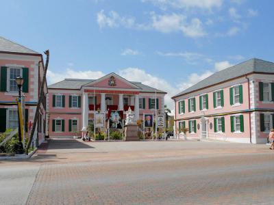
7) Parliament Square
Parliament Square developed in its present form in the early 19th century, following the arrival of Loyalists from the former American colonies who remained loyal to the British Crown after the American Revolutionary War. Their influence shaped both the layout of the square and the establishment of Nassau as a permanent seat of colonial government.
The square is visually defined by a tight grouping of pastel pink, Georgian-style government buildings arranged around an open civic space. Directly facing the square are the House of Assembly and the Senate of The Bahamas. The Supreme Court of The Bahamas sits slightly behind this frontage, visible beyond the main buildings rather than forming part of the square’s immediate edge.
The House of Assembly serves as the lower chamber of Parliament and is one of the oldest continuously operating legislative bodies in the Western Hemisphere, having first convened in 1729. When sessions are underway, visitors may observe debates from the public gallery, offering a direct view into parliamentary procedure within a historic setting. In front of the Senate Building stands a marble statue of Queen Victoria, erected in 1905.
Beyond the main parliamentary buildings, behind the Supreme Court, lies the Garden of Remembrance. This quieter, enclosed space contains a cenotaph commemorating Bahamian soldiers who died in the First and Second World Wars, with engraved plaques listing their names.
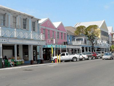
8) Bay Street (must see)
Bay Street is Nassau’s main commercial thoroughfare and its busiest shopping street. Running parallel to the harbor, it blends everyday retail with tourist-oriented shops. As you walk along the street, you’ll pass stores selling jewelry, watches, designer handbags, spirits, and souvenirs, alongside smaller vendors offering locally made crafts and beachwear.
The street also serves as a connective spine for many of downtown Nassau’s historical and cultural sites. Along or just off Bay Street are attractions such as the Pirates of Nassau Museum, the Nassau Public Library-housed in a former Carnegie Library building-Rawson Square, Parliament Square, and the Pompey Museum of Slavery & Emancipation. Toward the waterfront, tour operators and kiosks line the harbor side, offering short boat excursions, snorkeling trips, and island-hopping tours.
Retail highlights include several long-established cigar shops specializing in premium Cuban-style and Caribbean cigars, as well as duty-free stores popular with cruise visitors. Just off Bay Street, the Nassau Straw Market adds a more informal atmosphere, where bargaining is expected and straw goods, handicrafts, and souvenirs are sold in dense rows of stalls.
Dining options along Bay Street range from casual cafes to sit-down restaurants and bars. Many menus feature Bahamian staples such as conch fritters alongside familiar international dishes. For a more concentrated local food scene, Arawak Cay’s Fish Fry is located about one mile west of Rawson Square, where a cluster of restaurants serves traditional Bahamian cuisine in a lively setting.
