Custom Walk in Gibraltar, Gibraltar by hoffmane2_ff6ed9 created on 2026-05-19
Guide Location: Gibraltar » Gibraltar
Guide Type: Custom Walk
# of Sights: 8
Tour Duration: 5 Hour(s)
Travel Distance: 13 Km or 8.1 Miles
Share Key: BJJUA
Guide Type: Custom Walk
# of Sights: 8
Tour Duration: 5 Hour(s)
Travel Distance: 13 Km or 8.1 Miles
Share Key: BJJUA
How It Works
Please retrieve this walk in the GPSmyCity app. Once done, the app will guide you from one tour stop to the next as if you had a personal tour guide. If you created the walk on this website or come to the page via a link, please follow the instructions below to retrieve the walk in the app.
Retrieve This Walk in App
Step 1. Download the app "GPSmyCity: Walks in 1K+ Cities" on Apple App Store or Google Play Store.
Step 2. In the GPSmyCity app, download(or launch) the guide "Gibraltar Map and Walking Tours".
Step 3. Tap the menu button located at upper right corner of the "Walks" screen and select "Retrieve custom walk". Enter the share key: BJJUA

1) Gibraltar Botanic Gardens
The Gibraltar Botanic Gardens, known locally as La Alameda Gardens, are a green oasis that has soothed soldiers, sailors, and townsfolk for more than two centuries. The story begins in 1816, when Governor General George Don, weary of Gibraltar’s heat and dust, decided the people needed a refuge-a place, as he put it, “for recreation and refreshment.” The site he chose was then an empty military parade ground. Under his command, it was transformed into a terraced garden shaded by palms and jacarandas, offering respite to both British officers and local residents. The word “Alameda,” derived from Spanish, meaning a poplar-lined promenade, perfectly captured the governor’s vision of serenity amid the Rock’s fortifications.
An Italian landscape designer, Giuseppe Codali, later gave the gardens their romantic flourish in the 1870s. Legend has it that Codali, who was said to miss his native Lombardy’s greenery, poured his heart into reshaping Gibraltar’s stony slopes into something reminiscent of home. He created the Dell, a sunken Italian garden hidden beneath an arched bridge-still one of the most peaceful corners of the Alameda. During the 19th century, the gardens became the social heart of Gibraltar, hosting open-air concerts, public celebrations, and military parades. Locals recall that on warm evenings, the bandstand would fill with music while families strolled the terraces lit by lanterns.
By the late 20th century, the gardens had fallen into neglect but were lovingly restored in 1991, rekindling their old charm. Today, they are home to exotic plants from Africa and the Mediterranean, fountains and statues honoring Gibraltar’s past, and even a small wildlife park for rescued animals. For visitors, the Alameda Gardens are more than a botanical space-they are a living reminder that nature, history, and community can thrive together, even beneath the shadow of the Rock.
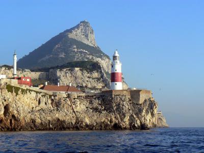
2) Europa Point (must see)
Europa Point (Punta de Europa) stands as the southernmost tip of Gibraltar. It holds significance as the southernmost point of the Iberian Peninsula, with Punta de Tarifa situated 25 kilometers southwest of Gibraltar. Nestled at the edge of the Rock of Gibraltar, this area boasts a level terrain adorned with notable features like a playing field and a handful of buildings.
On a clear day, one can admire panoramic views of North Africa across the Strait of Gibraltar, including sights of Ceuta and the Rif Mountains of Morocco. Additionally, the Bay of Gibraltar and the Spanish towns lining its shores can be seen. To reach Europa Point, one must traverse Europa Road starting from the old town.
Five remarkable buildings grace Europa Point, namely Harding's Battery, the Ibrahim-al-Ibrahim Mosque, the Roman Catholic Shrine of Our Lady of Europe, the Europa Point Lighthouse, and the Nun's Well. Moreover, Europa Point claims the distinction of housing Gibraltar's sole dedicated cricket oval, where the national cricket team competes. Since 2013, Europa Point has also served as the site of the Sikorski Memorial.
Dudley Ward Tunnel connects Europa Point to the eastern side of the Rock, linking it with Sandy Bay and Catalan Bay. After eight years of closure due to a tragic rockfall, the tunnel reopened in 2010.
In 2011, the Government of Gibraltar undertook a refurbishment project at Europa Point, which was inaugurated by Peter Caruana, the Chief Minister of Gibraltar at the time. As part of the renovations, an original RML 12.5-inch 38-ton gun was mounted on a custom-made replica carriage at Harding's Battery. Additionally, the memorial honoring General Wladislaw Sikorski was relocated to Europa Point from Sir Herbert Miles Road.
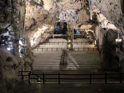
3) St. Michael's Cave (must see)
Rainwater, slowly seeping through limestone, will change into a weak solution of carbolic acid. The acid solution gradually erodes the limestone. It creates tunnels and caverns from cracks. This simple process has been carving away at the Rock of Gibraltar for thousands and thousands of years. The result is St. Michael's Cave.
St. Michael's Cave is really a vast network of tunnels and caves in the Upper Rock Nature Preserve of Gibraltar. Alonso Hernandez del Portillo, the leading historian of Gibraltar in the 17th century, held that the cave is named for the Grotto of Monte Gargano in Apulia, Italy, where archangel St. Michael is said to have appeared.
St. Michael would have felt at home. Humans certainly have, since Neolithic times. Pottery, utensils, weapons, and artwork of the Rock's prehistoric tenants have been found. A charcoal drawing of an Ibex is on a wall. The drawing is about 20,000 years old. There were two Neanderthal skulls found, dating from 40,000 years ago.
In 45 AD, geographer Pomponius Mela described Gibraltar as "A mountain with wonderful concavities." The caves were well-known to the ancient Greeks, Romans, and Phoenicians. In the Victorian era, the caves were used for picnics, concerts, marriages, and duels. In 1840 Colonel Mitchell and a friend went in and were never seen again.
In 1942, while blasting rocks in the cave to improve ventilation, a deeper system of caves and underground lakes was discovered. It was called New St. Michael's Cave. The largest room is called the Auditorium. It is used for a theatre space showing sound and light shows, beauty pageants, operas, and concerts.
St. Michael's Cave attracts over 1,000,000 visitors a year. The cave can be reached by car, by foot, or by cable car. Tickets include visits to the Moorish Castle and the Great Siege Tunnels of the Rock. Safety helmets are available. Non-skid shoes are recommended.

4) Main Street (must see)
Main Street is Gibraltar’s most famous thoroughfare-a place where the story of the Rock unfolds in every stone and balcony. Once known as Royal Street, it was first laid out in 1575 with the opening of the Africa Gate, now called the Southport Gates. But the street we know today began to take shape after 1704, when the British took Gibraltar and transformed it into a fortified garrison town. Main Street became the city’s central artery, buzzing with the energy of soldiers, merchants, and sailors from across Europe and North Africa.
Its history has not always been peaceful. During the Great Siege of 1779–1783, when French and Spanish forces bombarded Gibraltar for four years, much of Main Street was reduced to rubble. Yet from the ashes, it rose again. Governor Charles O’Hara oversaw its rebuilding in 1801, straightening the road and reshaping its facades into the elegant blend of Georgian, Mediterranean, and Moorish styles that still defines it.
There’s a story that during the siege, locals carried on trading and chatting in defiance, even as cannon fire echoed overhead-a sign of the Gibraltarian resilience that still characterizes the street. Later, in the 19th century, it evolved into a thriving commercial center. Tailors, tobacconists, and perfumeries lined its length, serving travelers and British officers alike, while families lived in apartments above the shops.
Today, Main Street remains the heart of Gibraltar’s daily life. It’s pedestrianized now, filled with duty-free stores, cozy pubs, and sunlit cafés. Tourists stroll between the cathedrals and colonial façades, hearing snippets of both English and Spanish-sometimes even Llanito, Gibraltar’s unique local dialect. Walking down Main Street isn’t just a shopping trip; it’s a walk through centuries of endurance, adaptation, and cultural exchange, where the Mediterranean meets a touch of Britain under the Rock’s watchful gaze.
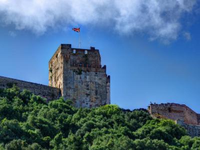
5) Moorish Castle
The medieval fortress in Gibraltar, known as the Moorish Castle, consists of various structures, gates, and fortified walls, prominently featuring the Tower of Homage and the Gate House. Until 2010, a section of the castle served as the prison of Gibraltar. The Tower of Homage, with its remarkable architecture and strategic position, is visible to all visitors.
The Moorish Castle was built by the Marinid dynasty, making it distinctive in the Iberian Peninsula. Construction of the castle began in the 8th century AD, potentially around AD 711, although the exact completion date remains unknown. The castle encompassed a substantial area, extending from the upper part of the Rock of Gibraltar down to the sea. The most prominent remaining parts of the structure are the Tower of Homage, along with terraces and battlements below it, as well as the substantial Gate House with its distinctive cupola roof.
Today, the Moorish Castle stands as a significant tourist attraction in Gibraltar and is featured on the reverse side of the still-circulating 1995 design of the Gibraltar five-pound banknote. Locally, the name "Moorish Castle" (or "El Castillo" in Spanish) also refers to the residential area surrounding the castle, known as the Moorish Castle Estate.

6) World War II Tunnels
During the Second World War, Gibraltar witnessed the most extensive phase of tunneling in its history, playing a crucial role in the North Atlantic and Mediterranean arenas. The war prompted a substantial increase in the length of tunnels, expanding from 7 miles (11 km) to 25 miles (40 km).
At the war's outset, the civilian population was evacuated, and the garrison size was significantly augmented. Numerous fresh tunnels were excavated to accommodate the expanded garrison and store vast quantities of provisions, equipment, and ammunition. This tunneling endeavor was undertaken by four specialized tunneling companies from the Royal Engineers and the Canadian Army.
A new Main Base Area was established in the southeastern part of Gibraltar, along the Mediterranean coast of the peninsula. This location protected the potentially hostile Spanish mainland while connecting tunnels were constructed to link it with the existing military bases on the western side. Two tunnels, known as the Great North Road and the Foss Way, were painstakingly dug, spanning nearly the entire length of the Rock, interconnecting the majority of the wartime tunnels.
The tunnels served as an underground city, capable of accommodating the entire 16,000-strong garrison and storing enough food to sustain them for 16 months. Within this subterranean complex, various facilities were established, including an underground telephone exchange, a power generating station, a water distillation plant, a hospital, a bakery, ammunition storage areas, and a vehicle maintenance workshop.
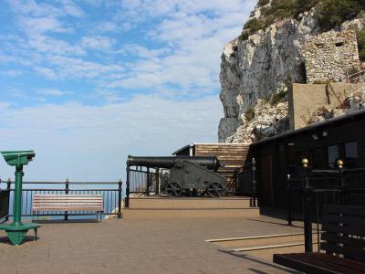
7) Great Siege Tunnels (must see)
The Upper Galleries, also known as the Great Siege Tunnels, is an intricate network of tunnels situated within the northern section of the Rock of Gibraltar, a British Overseas Territory. These tunnels were painstakingly carved out of solid limestone by the British forces during the late 18th century's Great Siege of Gibraltar.
The Great Siege of Gibraltar took place during the American Revolutionary War when France and Spain sought to capture Gibraltar from Great Britain. Spanning from July 1779 to February 1783, it marked the fourteenth and final siege of Gibraltar. The motivation behind constructing the tunnels stemmed from the garrison's necessity to cover a blind spot on the Rock's northeast side. The only viable solution was to position a gun on a rock spur referred to as The Notch.
The laborious task was executed manually, primarily employing sledgehammers, crowbars, and the aid of gunpowder explosions. Initially, progress was slow, with a team of thirteen men requiring five weeks to dig an 82-foot (25 m) long tunnel. The diggers faced challenges from noxious fumes and dust resulting from frequent blasting. Consequently, a horizontal shaft was blasted to enhance ventilation, which unexpectedly yielded an additional advantage.
By the completion of the initial phase of tunneling, five galleries were excavated: Windsor Gallery, King's and Queen's Lines, St. George's Hall, and Cornwallis Chamber. The Windsor Gallery constituted the first segment of the tunnel system and housed four mounted guns. St. George's Hall stood as the largest of the original galleries, and the embrasures on the Rock's slopes could be observed when approaching Gibraltar from both land and sea.
The onset of World War II led to increased tunnel construction. Extensive work was done to accommodate 16,000 soldiers with supplies for a year. The Great Siege Tunnels were repurposed, including an extension known as the Holyland Tunnel. A staircase was also built to connect the Tunnels to the Middle Galleries.
Presently, the Great Siege Tunnels are accessible as part of the Upper Rock Nature Reserve, offering visitors the opportunity to explore their historical significance.
8) Rock of Gibraltar (must see)
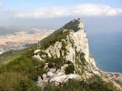
The Rock of Gibraltar stands as a majestic monolithic limestone promontory in the British territory of Gibraltar. Situated near the southwestern tip of Europe on the Iberian Peninsula, it guards the entrance to the Mediterranean Sea. Rising to an impressive height of 426 meters (1,398 feet), this iconic landmark captivates visitors with its natural beauty and rich history.
A significant portion of the Rock's upper area is dedicated to a nature reserve, creating a haven for diverse flora and fauna. One of the most famous inhabitants of the reserve is the Barbary macaque. Around 300 of these playful and charismatic monkeys roam freely on the Rock, delighting tourists with their antics. The presence of these macaques adds a unique and endearing aspect to the Rock's appeal.
Beyond its natural allure, the Rock of Gibraltar holds a prominent place in ancient mythology and historical significance. According to ancient legends propagated by the Greeks, Phoenicians, and later the Romans, the Rock, together with another pillar known as Mons Abila, formed the legendary Pillars of Hercules. These pillars were believed to mark the boundary of the known world.
The Rock of Gibraltar itself was known to the Romans as Mons Calpe. It served as a navigational landmark for ancient seafarers, symbolizing the end of the Mediterranean and the gateway to the vast Atlantic Ocean. While the Phoenicians had ventured beyond this point, exploring both northward and southward into the Atlantic, the Pillars of Hercules remained significant symbols of exploration and discovery.
In addition to its natural and mythological allure, the Rock of Gibraltar is also home to an intricate network of tunnels. These tunnels, created over centuries, were initially constructed for military purposes and later expanded during World War II. They served as a strategic defensive system, providing shelter, storage, and a hidden vantage point for the British forces.
Today, the Rock's tunnels are a popular attraction, offering visitors a glimpse into its military history and a chance to explore the subterranean world beneath the limestone cliffs. The combination of the Barbary macaques, the natural reserve, and the historical tunnels make the Rock of Gibraltar a captivating destination for tourists from around the world.
