Custom Walk in Kotor, Montenegro by jonahbtx_eb2aa4 created on 2026-07-12
Guide Location: Montenegro » Kotor
Guide Type: Custom Walk
# of Sights: 11
Tour Duration: 2 Hour(s)
Travel Distance: 2.1 Km or 1.3 Miles
Share Key: UJPNZ
Guide Type: Custom Walk
# of Sights: 11
Tour Duration: 2 Hour(s)
Travel Distance: 2.1 Km or 1.3 Miles
Share Key: UJPNZ
How It Works
Please retrieve this walk in the GPSmyCity app. Once done, the app will guide you from one tour stop to the next as if you had a personal tour guide. If you created the walk on this website or come to the page via a link, please follow the instructions below to retrieve the walk in the app.
Retrieve This Walk in App
Step 1. Download the app "GPSmyCity: Walks in 1K+ Cities" on Apple App Store or Google Play Store.



Step 2. In the GPSmyCity app, download(or launch) the guide "Kotor Map and Walking Tours".
Step 3. Tap the menu button located at upper right corner of the "Walks" screen and select "Retrieve custom walk". Enter the share key: UJPNZ
1) Craftsmen Street
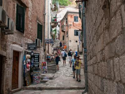
Often regarded as one of the oldest thoroughfares in Kotor, Craftsmen Street follows the city’s main north–south axis, running between the South Gate and the North Gate at the foot of the mountain. While its exact layout evolved over time, the street broadly follows the line of the ancient town’s primary route, linking Kotor’s key entrances from early periods onward.
From the Middle Ages well into the early modern era, Kotor was known for its skilled artisans, and this street became the city’s main craft corridor. Workshops were traditionally grouped by trade, creating a dense concentration of economic activity. Historical records, including documents from 1326, list dozens of professions active in the town, among them shoemakers, tanners, butchers, stonemasons, goldsmiths, blacksmiths, swordsmiths, and bakers.
As you walk today, souvenir shops and small studios occupy many former workshops, but traces of the street’s earlier function remain visible. Along the route, you’ll encounter religious buildings that once served both artisans and residents. The Church of Saint Anne, dating to the 12th century, was rebuilt following damage in the 1979 earthquake. Nearby stands the Church of Saint Paul, constructed in 1263.
Taken together, Craftsmen Street offers a compressed view of Kotor’s urban life, where trade, worship, and everyday movement once unfolded along a single, enduring spine of the city.
From the Middle Ages well into the early modern era, Kotor was known for its skilled artisans, and this street became the city’s main craft corridor. Workshops were traditionally grouped by trade, creating a dense concentration of economic activity. Historical records, including documents from 1326, list dozens of professions active in the town, among them shoemakers, tanners, butchers, stonemasons, goldsmiths, blacksmiths, swordsmiths, and bakers.
As you walk today, souvenir shops and small studios occupy many former workshops, but traces of the street’s earlier function remain visible. Along the route, you’ll encounter religious buildings that once served both artisans and residents. The Church of Saint Anne, dating to the 12th century, was rebuilt following damage in the 1979 earthquake. Nearby stands the Church of Saint Paul, constructed in 1263.
Taken together, Craftsmen Street offers a compressed view of Kotor’s urban life, where trade, worship, and everyday movement once unfolded along a single, enduring spine of the city.
2) Vrata od Gurdicа (Gurdic Gate or South Gate)
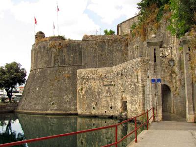
This 16th-century city gate, known as the Gurdić Gate, forms Kotor’s southern entrance and stands at a narrow point where the fortified town meets both the steep mountain slope and the waters of the bay. Historically, it controlled one of Kotor’s most important access routes, linking the walled city to the land approaches from the south. Today, it serves as a quieter entry point into the Old Town, away from the busier harbor-side gates.
The Gurdić Gate is distinguished by its complex defensive system, which included multiple successive gates and enclosed passages, designed to slow and trap attackers. A drawbridge once spanned the watercourse here, reinforcing the gate’s role as a key defensive threshold. The gate takes its name from the Gurdić River, which flows around the southern edge of the fortifications.
The river itself is unusual. It is fed by a karst spring that behaves intermittently: during periods of heavy rain, water surges out of the cave and flows strongly toward the bay, while in dry summer months the freshwater source weakens and seawater can flow back inland, reversing the direction of the stream. This natural feature added an extra layer of difficulty for anyone attempting to approach the city from this side.
The Gurdić Gate is distinguished by its complex defensive system, which included multiple successive gates and enclosed passages, designed to slow and trap attackers. A drawbridge once spanned the watercourse here, reinforcing the gate’s role as a key defensive threshold. The gate takes its name from the Gurdić River, which flows around the southern edge of the fortifications.
The river itself is unusual. It is fed by a karst spring that behaves intermittently: during periods of heavy rain, water surges out of the cave and flows strongly toward the bay, while in dry summer months the freshwater source weakens and seawater can flow back inland, reversing the direction of the stream. This natural feature added an extra layer of difficulty for anyone attempting to approach the city from this side.
3) Katedrala Svetog Tripuna (Saint Tryphon Cathedral and Square) (must see)
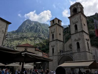
Saint Tryphon Cathedral is one of the city’s most important historical monuments, consecrated in 1166 and built on the site of an earlier 9th-century church dedicated to Saint Tryphon, Kotor’s patron saint.
The cathedral is a three-nave Romanesque structure that has undergone multiple phases of restoration. The most significant changes followed the 1667 earthquake, which damaged much of the facade and caused the collapse of the original bell towers. The towers were rebuilt in a Baroque style, giving the cathedral its present silhouette, while the facade retains Romanesque elements alongside later decorative additions. The rose windows, altered over time, reflect a blend of stylistic influences rather than a single medieval form.
Inside, the cathedral preserves an important collection of religious art and liturgical objects made of gold and silver, many produced by local craftsmen. Traces of medieval fresco decoration, attributed to Greek-trained painters, survive, though much has been lost. One of the interior’s focal points is the 14th-century ciborium above the main altar, combining Romanesque and Gothic features. Behind it stands the Golden Altarpiece, depicting Christ, the Virgin Mary, Saint John the Baptist, Saint Tryphon, and sixteen additional saints, a key work of Kotor’s goldsmith tradition.
Access to the cathedral includes entry to the Sacral Art Collection, which displays reliquaries, icons, manuscripts, and vestments associated with the cathedral’s history. The modest entrance fee supports conservation while allowing the cathedral to function primarily as a place of worship.
Adjacent to the cathedral is the Bishop’s Palace, historically the residence of Kotor’s bishops. The building incorporates elements of earlier noble residences, including associations with the Drago family, reflecting the close ties between ecclesiastical authority and local aristocracy.
The cathedral is a three-nave Romanesque structure that has undergone multiple phases of restoration. The most significant changes followed the 1667 earthquake, which damaged much of the facade and caused the collapse of the original bell towers. The towers were rebuilt in a Baroque style, giving the cathedral its present silhouette, while the facade retains Romanesque elements alongside later decorative additions. The rose windows, altered over time, reflect a blend of stylistic influences rather than a single medieval form.
Inside, the cathedral preserves an important collection of religious art and liturgical objects made of gold and silver, many produced by local craftsmen. Traces of medieval fresco decoration, attributed to Greek-trained painters, survive, though much has been lost. One of the interior’s focal points is the 14th-century ciborium above the main altar, combining Romanesque and Gothic features. Behind it stands the Golden Altarpiece, depicting Christ, the Virgin Mary, Saint John the Baptist, Saint Tryphon, and sixteen additional saints, a key work of Kotor’s goldsmith tradition.
Access to the cathedral includes entry to the Sacral Art Collection, which displays reliquaries, icons, manuscripts, and vestments associated with the cathedral’s history. The modest entrance fee supports conservation while allowing the cathedral to function primarily as a place of worship.
Adjacent to the cathedral is the Bishop’s Palace, historically the residence of Kotor’s bishops. The building incorporates elements of earlier noble residences, including associations with the Drago family, reflecting the close ties between ecclesiastical authority and local aristocracy.
4) Trg od Brasna (Flour Square)
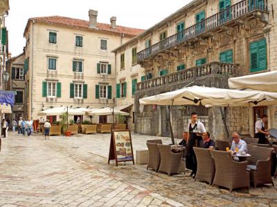
Flour Square reflects its historical function as a place for the storage and trade of flour. The square is architecturally significant, framed by two of Kotor’s most important noble residences. Facing east, you’ll see the Pima Palace, built in the 17th century. The building combines Renaissance balance with Baroque ornamentation. Its most distinctive feature is the long stone balcony running across the main floor. Above the balcony, look for the Pima family coat of arms, held by two carved angels.
Now turn to face west, directly opposite the Pima Palace. Here stands the Buća Palace, whose origins date back to the 14th century, representing an earlier Gothic phase of Kotor’s architecture. What you see today is no longer a single unified structure. After the 1667 earthquake, the palace was subdivided into three adjoining buildings. Differences in height, window placement, and facade treatment reveal these successive stages of rebuilding.
Part of the Pima Palace houses the Gallery of Solidarity, which hosts rotating art exhibitions and adds a contemporary cultural layer to the square. Nearby, left to the Buća Palace, Hotel Astoria operates within a restored historic structure, illustrating how medieval architecture has been adapted for modern hospitality while preserving its historic character.
Finally, shift your attention toward the northern side of the square. At house number 328, archaeological excavations uncovered the remains of a medieval church, believed to have originated as a private chapel of the Buća family.
Now turn to face west, directly opposite the Pima Palace. Here stands the Buća Palace, whose origins date back to the 14th century, representing an earlier Gothic phase of Kotor’s architecture. What you see today is no longer a single unified structure. After the 1667 earthquake, the palace was subdivided into three adjoining buildings. Differences in height, window placement, and facade treatment reveal these successive stages of rebuilding.
Part of the Pima Palace houses the Gallery of Solidarity, which hosts rotating art exhibitions and adds a contemporary cultural layer to the square. Nearby, left to the Buća Palace, Hotel Astoria operates within a restored historic structure, illustrating how medieval architecture has been adapted for modern hospitality while preserving its historic character.
Finally, shift your attention toward the northern side of the square. At house number 328, archaeological excavations uncovered the remains of a medieval church, believed to have originated as a private chapel of the Buća family.
5) Morska vrata (Sea Gate)
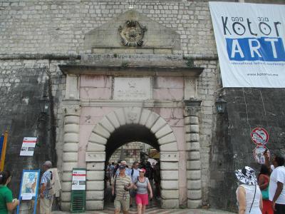
The main entrance to Kotor’s fortified city, known as the Sea Gate, was built in 1555 during Venetian rule, from 1420 to 1797. Above the gate, you’ll notice the winged lion of Saint Mark, the emblem of Venice, also visible at several other points around the old town. Sharing the same space is a later historical layer: a red communist star and a post–Second World War inscription reading, “What belongs to others we don’t want, what is ours we will never surrender”, a slogan commonly attributed to Josip Broz Tito, a communist revolutionary and former president of Yugoslavia.
Although sections have deteriorated over time, the remaining structure still conveys the scale and ambition of Kotor’s fortifications. Originally accessible only from the sea, the gate has subsided by more than 70 centimeters since its construction, largely due to the immense weight of its stone masonry and the unstable ground beneath.
As you pass through the gate, look for the 15th-century stone relief of the Madonna and Child, flanked by Saint Tryphon, Kotor’s patron saint, and Saint Bernard of Clairvaux. Beyond it, the space opens directly onto Arms Square, once the city’s main administrative and military hub and today the natural starting point for exploring the cobbled streets of Kotor’s old town.
Although sections have deteriorated over time, the remaining structure still conveys the scale and ambition of Kotor’s fortifications. Originally accessible only from the sea, the gate has subsided by more than 70 centimeters since its construction, largely due to the immense weight of its stone masonry and the unstable ground beneath.
As you pass through the gate, look for the 15th-century stone relief of the Madonna and Child, flanked by Saint Tryphon, Kotor’s patron saint, and Saint Bernard of Clairvaux. Beyond it, the space opens directly onto Arms Square, once the city’s main administrative and military hub and today the natural starting point for exploring the cobbled streets of Kotor’s old town.
6) Trg od Oruzja (Arms Square) (must see)
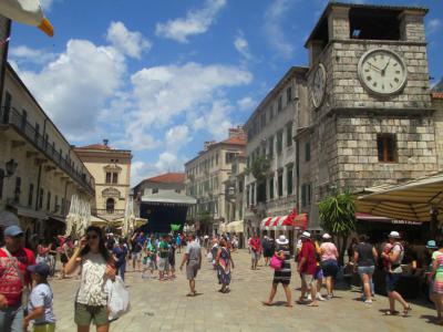
As you pass through the Sea Gate, you’ll find yourself in Arms Square, the largest and most open space within Kotor’s walled city. This square has long served as the city’s civic and military center and today remains busy with cafes, shops, banks, and public buildings arranged around its edges.
Facing back toward the Sea Gate, look slightly to your left to locate the Clock Tower, built in 1602. Its noticeable tilt is the result of earthquake damage rather than age alone, and its form blends Baroque features with older construction traditions. Nearby, close to the base of the tower, stands the medieval pillar of justice, once used for public punishments and official proclamations.
Now go toward the western side of the square. Here you’ll see the Prince’s Palace, historically the seat of Venetian administration and now incorporated into Hotel Cattaro. Adjacent to it is the former Arsenal, where weapons were produced and stored during Venetian rule. This area was the operational heart of Kotor’s defenses, and soldiers once gathered here to collect arms and prepare for battle.
As you look toward the western side of the square, on your right you’ll come to the building that houses the Napoleon Theatre. . Originally constructed in 1762 as a military warehouse for supplies and food, it was converted into a theater during the French administration in the early 19th century, becoming one of the earliest theaters in the Balkans.
From this square, the events of 1539 still resonate. It was here that defenders organized their resistance when Kotor withstood a siege by the Ottoman admiral Hajrudin Barbarossa, holding out for more than a week until his fleet withdrew.
Facing back toward the Sea Gate, look slightly to your left to locate the Clock Tower, built in 1602. Its noticeable tilt is the result of earthquake damage rather than age alone, and its form blends Baroque features with older construction traditions. Nearby, close to the base of the tower, stands the medieval pillar of justice, once used for public punishments and official proclamations.
Now go toward the western side of the square. Here you’ll see the Prince’s Palace, historically the seat of Venetian administration and now incorporated into Hotel Cattaro. Adjacent to it is the former Arsenal, where weapons were produced and stored during Venetian rule. This area was the operational heart of Kotor’s defenses, and soldiers once gathered here to collect arms and prepare for battle.
As you look toward the western side of the square, on your right you’ll come to the building that houses the Napoleon Theatre. . Originally constructed in 1762 as a military warehouse for supplies and food, it was converted into a theater during the French administration in the early 19th century, becoming one of the earliest theaters in the Balkans.
From this square, the events of 1539 still resonate. It was here that defenders organized their resistance when Kotor withstood a siege by the Ottoman admiral Hajrudin Barbarossa, holding out for more than a week until his fleet withdrew.
7) Crkva Svetog Nikole (Church of St. Nicholas)
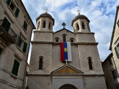
The Church of Saint Nicholas was consecrated in 1909, replacing an earlier 17th-century Orthodox church that was destroyed in a fire on Christmas Eve in 1896. Its commanding appearance is defined by two tall bell towers, topped with black domes and gilded crosses, which were donated by Imperial Russia, reflecting close Orthodox ties at the time.
The church was designed by Ćiril Iveković, a well-known Croatian architectural engineer and conservationist active across the Adriatic region, from Zadar to Kotor. His work included churches, rectories, and public buildings, and he also played an important role in heritage preservation.
Architecturally, the church follows a Neo-Byzantine style, its interior being dominated by a richly carved iconostasis completed in 1908, along with an extensive collection of icons. Among them is a revered copy of the Icon of the Holy Mother of God Three-handed. The church also preserves religious books, liturgical objects, and artworks donated by prominent families from Kotor and the surrounding region.
Today, Saint Nicholas is the main Orthodox church in Kotor and the only one in the Old Town where daily liturgies are held. The flag of the Serbian Orthodox Church is typically displayed on the facade, marking its active role in the city’s religious life.
The church was designed by Ćiril Iveković, a well-known Croatian architectural engineer and conservationist active across the Adriatic region, from Zadar to Kotor. His work included churches, rectories, and public buildings, and he also played an important role in heritage preservation.
Architecturally, the church follows a Neo-Byzantine style, its interior being dominated by a richly carved iconostasis completed in 1908, along with an extensive collection of icons. Among them is a revered copy of the Icon of the Holy Mother of God Three-handed. The church also preserves religious books, liturgical objects, and artworks donated by prominent families from Kotor and the surrounding region.
Today, Saint Nicholas is the main Orthodox church in Kotor and the only one in the Old Town where daily liturgies are held. The flag of the Serbian Orthodox Church is typically displayed on the facade, marking its active role in the city’s religious life.
8) Crkva Svetog Luke (Church of St. Luke)
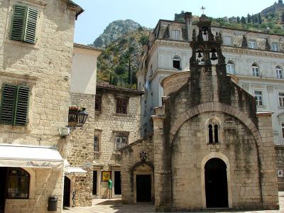
As you exit the Church of Saint Nicholas, directly in front of you stands the much smaller Church of Saint Luke, one of Kotor’s five surviving Romanesque churches. Built in 1195, during a period of strong Byzantine influence-just before Kotor came under the rule of the Serbian Nemanjić dynasty-its compact size and restrained exterior set it apart from the larger churches nearby.
The church follows a single-nave plan, with a semicircular apse extending from the eastern end. Above the central bay rises a dome set on a circular drum, visible from outside. The building’s modest scale played a practical role: it helped the church withstand the earthquakes that damaged many larger monuments in Kotor.
Step inside and look along the southern wall, where fragments of medieval frescoes survive, offering a glimpse of the church’s original interior decoration. Moving your gaze toward the sanctuary, you’ll see the iconostasis, dating from the 17th century and attributed to Dimitrije Daskal. Its style reflects the Boka Kotorska painting school, which combined Orthodox iconographic traditions with local artistic influences.
Saint Luke’s is especially notable for its dual Catholic and Orthodox history. In 1657, during an Ottoman incursion into the region, Orthodox refugees from Grbalj were allowed by Venetian authorities to worship here, even though the church was then Catholic. As a result, a second altar was installed along the north side of the interior, allowing both rites to be practiced side by side.
This unusual arrangement lasted until the French administration from 1807 to 1814, after which the church became exclusively Orthodox. Before leaving, look down at the floor. The stone slabs beneath your feet are tombstones from communal graves, used for burials inside the church until the 1930s.
The church follows a single-nave plan, with a semicircular apse extending from the eastern end. Above the central bay rises a dome set on a circular drum, visible from outside. The building’s modest scale played a practical role: it helped the church withstand the earthquakes that damaged many larger monuments in Kotor.
Step inside and look along the southern wall, where fragments of medieval frescoes survive, offering a glimpse of the church’s original interior decoration. Moving your gaze toward the sanctuary, you’ll see the iconostasis, dating from the 17th century and attributed to Dimitrije Daskal. Its style reflects the Boka Kotorska painting school, which combined Orthodox iconographic traditions with local artistic influences.
Saint Luke’s is especially notable for its dual Catholic and Orthodox history. In 1657, during an Ottoman incursion into the region, Orthodox refugees from Grbalj were allowed by Venetian authorities to worship here, even though the church was then Catholic. As a result, a second altar was installed along the north side of the interior, allowing both rites to be practiced side by side.
This unusual arrangement lasted until the French administration from 1807 to 1814, after which the church became exclusively Orthodox. Before leaving, look down at the floor. The stone slabs beneath your feet are tombstones from communal graves, used for burials inside the church until the 1930s.
9) Trg Bokeljske Mornarice (Boka Navy Square)
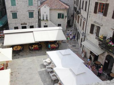
Boka Navy Square is a small but historically dense square in Kotor’s Old Town. The square opens slightly wider than the surrounding streets and functions as a junction between residential, civic, and maritime spaces.
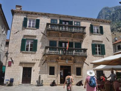
If you face north, the most prominent building in front of you is the Grgurina Palace, a Baroque residence built in the early 18th century with stone brought from Korčula. Today it houses the Maritime Museum of Montenegro, but from the outside, notice the balanced facade and stone balconies that reflect the wealth of Kotor’s seafaring elite.
In the middle of the square, look down for a square stone cover set into the pavement that marks the Karampana well, a small stone structure that supplied drinking water to the city for centuries. Its current form dates to the early 18th century. Look closely at the wrought-iron structure above it, traditionally attributed to local blacksmiths. Although it stopped functioning in 1958, the well remained a long-standing gathering point for news and conversation.
Now turn toward west. Along this side of the square, you’ll see a row of souvenir and handmade-goods shops, their display windows and awnings spilling toward the stone pavement and giving this edge of the square a more commercial, everyday feel.
If you face north, the most prominent building in front of you is the Grgurina Palace, a Baroque residence built in the early 18th century with stone brought from Korčula. Today it houses the Maritime Museum of Montenegro, but from the outside, notice the balanced facade and stone balconies that reflect the wealth of Kotor’s seafaring elite.
In the middle of the square, look down for a square stone cover set into the pavement that marks the Karampana well, a small stone structure that supplied drinking water to the city for centuries. Its current form dates to the early 18th century. Look closely at the wrought-iron structure above it, traditionally attributed to local blacksmiths. Although it stopped functioning in 1958, the well remained a long-standing gathering point for news and conversation.
Now turn toward west. Along this side of the square, you’ll see a row of souvenir and handmade-goods shops, their display windows and awnings spilling toward the stone pavement and giving this edge of the square a more commercial, everyday feel.
10) Museum Maritimum (Grgurin Palace and Maritime Museum)
Kotor’s maritime heritage is presented in an early-18th-century Baroque palace, the Grgurina Palace, which today houses the Maritime Museum of Montenegro. Spread across three exhibition floors, the museum explores the city’s long relationship with the sea through photographs, paintings, uniforms, finely crafted weapons, navigational instruments, and detailed ship models. An audio guide helps place these objects within their historical and cultural context.
Kotor’s seafaring tradition reaches back to the Middle Ages and is closely linked to the Boka Navy, a maritime brotherhood traditionally dated to 809. The museum preserves the memory of generations of sailors and captains, alongside shipbuilders, craftsmen, artists, politicians, and diplomats whose activities connected the Adriatic with both the eastern Mediterranean and Western Europe.
Among the highlights are six bronze relief panels illustrating key historical events and figures from Kotor’s often turbulent past. The collection also includes nautical charts, geographic maps, engravings, and watercolors depicting coastal towns of the bay, as well as an ethnographic section that offers insight into maritime life between the 16th and 18th centuries, a period when Kotor reached the height of its seafaring influence.
At the entrance to the palace, look for two small historic cannons, a reminder of the constant threat of piracy in Adriatic waters and the defensive role seafarers were forced to assume. Together, the building and its collections provide a compact but detailed overview of how deeply maritime life shaped Kotor’s identity.
Kotor’s seafaring tradition reaches back to the Middle Ages and is closely linked to the Boka Navy, a maritime brotherhood traditionally dated to 809. The museum preserves the memory of generations of sailors and captains, alongside shipbuilders, craftsmen, artists, politicians, and diplomats whose activities connected the Adriatic with both the eastern Mediterranean and Western Europe.
Among the highlights are six bronze relief panels illustrating key historical events and figures from Kotor’s often turbulent past. The collection also includes nautical charts, geographic maps, engravings, and watercolors depicting coastal towns of the bay, as well as an ethnographic section that offers insight into maritime life between the 16th and 18th centuries, a period when Kotor reached the height of its seafaring influence.
At the entrance to the palace, look for two small historic cannons, a reminder of the constant threat of piracy in Adriatic waters and the defensive role seafarers were forced to assume. Together, the building and its collections provide a compact but detailed overview of how deeply maritime life shaped Kotor’s identity.
11) Tvrdava Svetog Ivana (St. John's Castle) (must see)
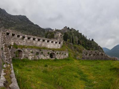
Rising above Kotor on the slope of the mountain, this fortress stands about 260 meters above sea level and is reached by a steep path that climbs through a long series of bends and more than 1,300 stone steps. From the top, the view opens across the Old Town’s rooftops, the winding bay below, and the surrounding mountains.
The fortress takes its name from the Church of Saint John the Baptist, located within the upper citadel and first mentioned in 1440. The church served the garrison responsible for guarding the city’s walls and gave the entire complex its traditional name. The defensive system surrounding Kotor is extensive: the walls stretch for several kilometers, climbing from the shoreline up the mountainside, with sections that vary greatly in height and thickness depending on terrain and period of construction.
The fortifications developed gradually over many centuries. Early defensive structures are traditionally linked to the reign of Emperor Justinian in the 6th century, though much of what is visible today reflects later rebuilding. The walls and bastions were repeatedly strengthened, with their present form largely shaped during the Venetian period, particularly in the 16th and 17th centuries, in response to Ottoman threats.
Partway up the ascent stands the Church of Our Lady of Health, built in the 16th century following outbreaks of plague. It became a place of prayer for protection and healing. Along the route, several small chapels once marked the path; their painted panels depicting Marian feasts are now preserved inside the church.
The fortress takes its name from the Church of Saint John the Baptist, located within the upper citadel and first mentioned in 1440. The church served the garrison responsible for guarding the city’s walls and gave the entire complex its traditional name. The defensive system surrounding Kotor is extensive: the walls stretch for several kilometers, climbing from the shoreline up the mountainside, with sections that vary greatly in height and thickness depending on terrain and period of construction.
The fortifications developed gradually over many centuries. Early defensive structures are traditionally linked to the reign of Emperor Justinian in the 6th century, though much of what is visible today reflects later rebuilding. The walls and bastions were repeatedly strengthened, with their present form largely shaped during the Venetian period, particularly in the 16th and 17th centuries, in response to Ottoman threats.
Partway up the ascent stands the Church of Our Lady of Health, built in the 16th century following outbreaks of plague. It became a place of prayer for protection and healing. Along the route, several small chapels once marked the path; their painted panels depicting Marian feasts are now preserved inside the church.
