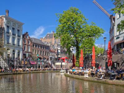


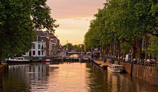
Oudegracht (Old Canal), Utrecht (must see)
This canal is likely the most famous in the city since it runs the entire length of the town from north to south. It is two kilometers long and connects Kromme Rijn and the Vecht.
When the Romans settled in the area, they chose the spot where the Vecht split from the Rhine. Unfortunately, the Rhine had begun to silt, and a dam built in 1122 threatened to limit navigation to Utrecht drastically. So a series of canals were built to compensate for these issues.
These canals served several purposes. First, they connected the town to the Rhine and the North Sea for trade routes. They also served a defensive purpose--many were used for moats around castles. Plus, the silt dug to make the canals was piled on the sides, which braced the community from flooding.
By creating a waterworks system, water levels in the canal are kept at a constant level. This enabled many homes and buildings along the canal to build quays and storage cellars, which eventually grew into wharves. By the 15th century, the city has a two-kilometer-long harbor of wharves with storage cellars.
An impressive collection of 16 beautiful bridges cross the Oudegracht. Most of these have two arches each, but a few have only one arch.
Want to visit this sight? Check out these Self-Guided Walking Tours in Utrecht. Alternatively, you can download the mobile app "GPSmyCity: Walks in 1K+ Cities" from Apple App Store or Google Play Store. The app turns your mobile device to a personal tour guide and it works offline, so no data plan is needed when traveling abroad.
Download The GPSmyCity App
Oudegracht (Old Canal) on Map
Sight Name: Oudegracht (Old Canal)
Sight Location: Utrecht, Netherlands (See walking tours in Utrecht)
Sight Type: Attraction/Landmark
Guide(s) Containing This Sight:
Sight Location: Utrecht, Netherlands (See walking tours in Utrecht)
Sight Type: Attraction/Landmark
Guide(s) Containing This Sight:
Nearby Sights

Walking Tours in Utrecht, Netherlands

Create Your Own Walk in Utrecht
Creating your own self-guided walk in Utrecht is easy and fun. Choose the city attractions that you want to see and a walk route map will be created just for you. You can even set your hotel as the start point of the walk.
Utrecht Introduction Walking Tour
The earliest settlers to the area now called Utrecht likely arrived millennia ago during the Stone Age. While there are also signs of inhabitation during the Bronze Age, scholars today credit the Romans with building what became the town.
They set up a castellum around the year 50 AD, a fort right at a crossing point on the river Rhine. The fortress marked Rome's northernmost point in... view more
Tour Duration: 1 Hour(s)
Travel Distance: 1.6 Km or 1 Miles
They set up a castellum around the year 50 AD, a fort right at a crossing point on the river Rhine. The fortress marked Rome's northernmost point in... view more
Tour Duration: 1 Hour(s)
Travel Distance: 1.6 Km or 1 Miles
Utrecht's Historical Buildings Walking Tour
Originally founded by the Romans, and once the most important city in the Netherlands, Utrecht boasts a generous share of historically significant structures. The collection of its architectural masterpieces, one of the richest in the country, dates back to the early Middle Ages.
The amazingly well-preserved pieces of historic architecture in Utrecht showcase the trends and movements throughout... view more
Tour Duration: 2 Hour(s)
Travel Distance: 3.8 Km or 2.4 Miles
The amazingly well-preserved pieces of historic architecture in Utrecht showcase the trends and movements throughout... view more
Tour Duration: 2 Hour(s)
Travel Distance: 3.8 Km or 2.4 Miles