

Prado, Montevideo
Prado is a picturesque and historically rich neighborhood located in Montevideo. It is recognized as one of the city's 62 official neighborhoods and serves as a residential area that revolves around the expansive park also named Prado. The neighborhood is bordered by Millán Avenue to the east, Artigas Boulevard to the south, and Manuel Correa Street to the west.
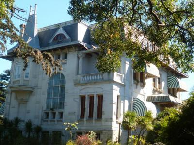
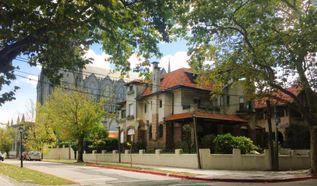
The area is divided between Municipalities A and C, featuring a mix of stunning architectural styles with large, old mansions and palaces that date back to the 19th and early 20th centuries. Notably, it includes the Suárez y Reyes Residence, which serves as the official residence of the President of Uruguay.
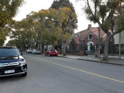
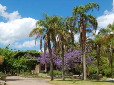
Originally a fertile agricultural area outside Montevideo's city limits in the early 19th century, Prado transformed from agricultural estates into residential homes with gardens during the mid-19th century. Post-Great War, it became a summer retreat for the upper class by 1851, leading to the construction of country houses. By the 1890s, as Montevideo grew, Prado evolved into a permanent upscale residential neighborhood, characterized by grand mansions, tree-lined avenues, and recreational green spaces.
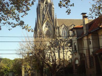
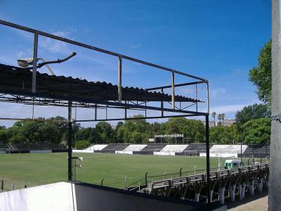
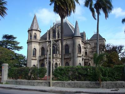
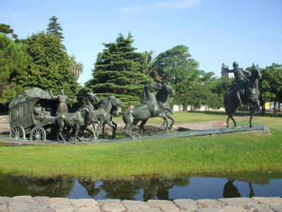
Today, the Prado neighborhood has three soccer stadiums: José Nasazzi Park, Federico Saroldi Park, and Alfredo V. Viera Park. These are the home fields for the Bella Vista Athletic Club, River Plate Athletic Club, and Montevideo Wanderers soccer teams, respectively. Additionally, the Prado neighborhood features the Carmelitas Church, Castillo Soneira, and several other attractive historic villas.
Prado remains a culturally and historically significant neighborhood in Montevideo, also known for being home to several notable cultural and political figures such as Carlos Vaz Ferreira, Donato Racciatti, Lauro Ayestarán, Sergio Curto, and Felisberto Hernández, further enhancing its unique charm and appeal.
The area is divided between Municipalities A and C, featuring a mix of stunning architectural styles with large, old mansions and palaces that date back to the 19th and early 20th centuries. Notably, it includes the Suárez y Reyes Residence, which serves as the official residence of the President of Uruguay.
Originally a fertile agricultural area outside Montevideo's city limits in the early 19th century, Prado transformed from agricultural estates into residential homes with gardens during the mid-19th century. Post-Great War, it became a summer retreat for the upper class by 1851, leading to the construction of country houses. By the 1890s, as Montevideo grew, Prado evolved into a permanent upscale residential neighborhood, characterized by grand mansions, tree-lined avenues, and recreational green spaces.
Today, the Prado neighborhood has three soccer stadiums: José Nasazzi Park, Federico Saroldi Park, and Alfredo V. Viera Park. These are the home fields for the Bella Vista Athletic Club, River Plate Athletic Club, and Montevideo Wanderers soccer teams, respectively. Additionally, the Prado neighborhood features the Carmelitas Church, Castillo Soneira, and several other attractive historic villas.
Prado remains a culturally and historically significant neighborhood in Montevideo, also known for being home to several notable cultural and political figures such as Carlos Vaz Ferreira, Donato Racciatti, Lauro Ayestarán, Sergio Curto, and Felisberto Hernández, further enhancing its unique charm and appeal.
Want to visit this sight? Check out these Self-Guided Walking Tours in Montevideo. Alternatively, you can download the mobile app "GPSmyCity: Walks in 1K+ Cities" from Apple App Store or Google Play Store. The app turns your mobile device to a personal tour guide and it works offline, so no data plan is needed when traveling abroad.
Download The GPSmyCity App
Prado on Map
Sight Name: Prado
Sight Location: Montevideo, Uruguay (See walking tours in Montevideo)
Sight Type: Attraction/Landmark
Sight Location: Montevideo, Uruguay (See walking tours in Montevideo)
Sight Type: Attraction/Landmark
Nearby Sights
Walking Tours in Montevideo, Uruguay

Create Your Own Walk in Montevideo
Creating your own self-guided walk in Montevideo is easy and fun. Choose the city attractions that you want to see and a walk route map will be created just for you. You can even set your hotel as the start point of the walk.
Prado District Walking Tour
The Prado is one of Montevideo’s oldest and most historically layered districts, shaped by a long transition from rural outskirts to a residential and cultural area closely linked to the city’s elite and intellectual life. The name Prado comes from the Spanish word for “meadow” or “pasture”, reflecting the area’s original landscape: open grasslands along the Miguelete Stream.
... view more
Tour Duration: 2 Hour(s)
Travel Distance: 3.6 Km or 2.2 Miles
... view more
Tour Duration: 2 Hour(s)
Travel Distance: 3.6 Km or 2.2 Miles
Montevideo Old Town Walking Tour
In Charles Darwin's journals, who visited Montevideo in the 1830s during the voyage of the Beagle, he observed that the city felt like “a town living in a state of perpetual expectation”, shaped by sieges, trade, and uncertainty.
Montevideo is the capital and largest city of Uruguay, shaped by its position on the northern bank of the River Plate and by centuries of rivalry between... view more
Tour Duration: 2 Hour(s)
Travel Distance: 2.5 Km or 1.6 Miles
Montevideo is the capital and largest city of Uruguay, shaped by its position on the northern bank of the River Plate and by centuries of rivalry between... view more
Tour Duration: 2 Hour(s)
Travel Distance: 2.5 Km or 1.6 Miles