

Audio Guide: Prado District Walking Tour (Self Guided), Montevideo
The Prado is one of Montevideo’s oldest and most historically layered districts, shaped by a long transition from rural outskirts to a residential and cultural area closely linked to the city’s elite and intellectual life. The name Prado comes from the Spanish word for “meadow” or “pasture”, reflecting the area’s original landscape: open grasslands along the Miguelete Stream.
During the late 18th and early 19th centuries, the Prado began to gain importance as Montevideo expanded beyond its walled core. Wealthy families started acquiring land in the area, drawn by its fresh air, water sources, and gentle terrain. By the mid-19th century, the Prado had become a favored location for country villas surrounded by gardens used as summer residences by the upper classes.
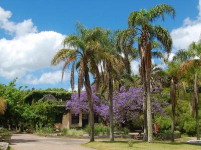
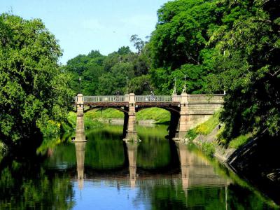
The formal shaping of the Prado accelerated in the second half of the 19th century, particularly after Uruguay’s independence and the consolidation of Montevideo as the national capital. Public works and urban planning initiatives aimed to preserve the area’s green character while integrating it into the growing city. The creation of the Prado Park , designed with landscaped paths, tree-lined avenues, and ornamental features, reinforced the district’s identity as a space for leisure, culture, and social life.
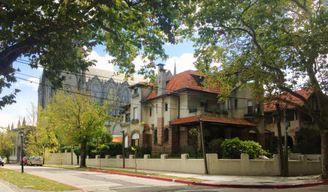
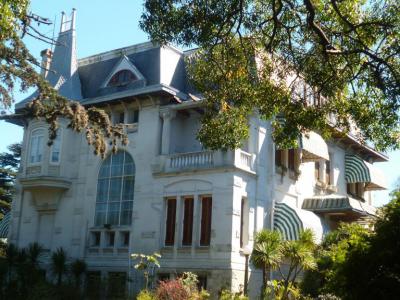
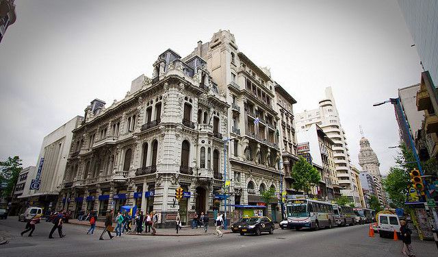
Architecturally, the Prado reflects its role as a residential enclave for Montevideo’s political, cultural, and economic elites. Elegant mansions from the late 19th and early 20th centuries, influenced by European styles such as neoclassicism and eclecticism, line many of its streets. Several of these residences were later repurposed as museums, embassies, or cultural institutions.
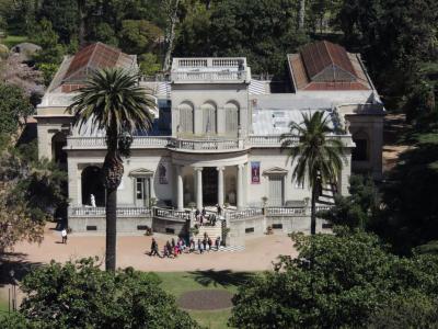
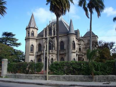
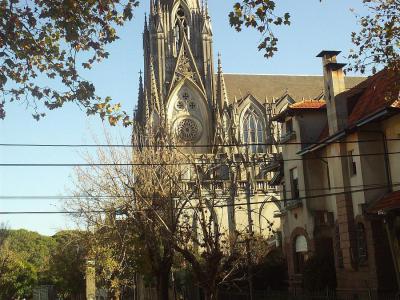
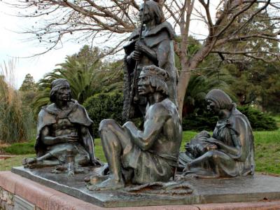
Walking through Montevideo’s Prado District, visitors encounter a mix of culture, architecture, and greenery. The Juan Manuel Blanes Museum introduces national art within a refined historic residence, while Soneira Castle adds a touch of romantic eccentricity. The Suarez Residence reflects political history, the Botanical Garden offers calm paths and diverse plant life, and the Carmelite Church stands out with its neo-Gothic silhouette among leafy streets.
In the 20th century, the Prado maintained its reputation as a green, refined neighborhood, even as Montevideo continued to expand. The area is protected as a National Historic Landmark, which explains why so many of those 19th-century mansions remain intact. Today, it stands as a reminder of the city’s pastoral origins and its 19th-century aspirations, combining historic architecture, cultural institutions, and expansive green spaces in a district whose name still echoes the meadows that once defined it.
During the late 18th and early 19th centuries, the Prado began to gain importance as Montevideo expanded beyond its walled core. Wealthy families started acquiring land in the area, drawn by its fresh air, water sources, and gentle terrain. By the mid-19th century, the Prado had become a favored location for country villas surrounded by gardens used as summer residences by the upper classes.
The formal shaping of the Prado accelerated in the second half of the 19th century, particularly after Uruguay’s independence and the consolidation of Montevideo as the national capital. Public works and urban planning initiatives aimed to preserve the area’s green character while integrating it into the growing city. The creation of the Prado Park , designed with landscaped paths, tree-lined avenues, and ornamental features, reinforced the district’s identity as a space for leisure, culture, and social life.
Architecturally, the Prado reflects its role as a residential enclave for Montevideo’s political, cultural, and economic elites. Elegant mansions from the late 19th and early 20th centuries, influenced by European styles such as neoclassicism and eclecticism, line many of its streets. Several of these residences were later repurposed as museums, embassies, or cultural institutions.
Walking through Montevideo’s Prado District, visitors encounter a mix of culture, architecture, and greenery. The Juan Manuel Blanes Museum introduces national art within a refined historic residence, while Soneira Castle adds a touch of romantic eccentricity. The Suarez Residence reflects political history, the Botanical Garden offers calm paths and diverse plant life, and the Carmelite Church stands out with its neo-Gothic silhouette among leafy streets.
In the 20th century, the Prado maintained its reputation as a green, refined neighborhood, even as Montevideo continued to expand. The area is protected as a National Historic Landmark, which explains why so many of those 19th-century mansions remain intact. Today, it stands as a reminder of the city’s pastoral origins and its 19th-century aspirations, combining historic architecture, cultural institutions, and expansive green spaces in a district whose name still echoes the meadows that once defined it.
How it works: Download the app "GPSmyCity: Walks in 1K+ Cities" from Apple App Store or Google Play Store to your mobile phone or tablet. The app turns your mobile device into a personal tour guide and its built-in GPS navigation functions guide you from one tour stop to next. The app works offline, so no data plan is needed when traveling abroad.
Download The GPSmyCity App
Prado District Walking Tour Map
Guide Name: Prado District Walking Tour
Guide Location: Uruguay » Montevideo (See other walking tours in Montevideo)
Guide Type: Self-guided Walking Tour (Sightseeing)
Tour Duration: 2 Hour(s)
Travel Distance: 3.6 Km or 2.2 Miles
Guide Location: Uruguay » Montevideo (See other walking tours in Montevideo)
Guide Type: Self-guided Walking Tour (Sightseeing)
Tour Duration: 2 Hour(s)
Travel Distance: 3.6 Km or 2.2 Miles
Sights Featured in This Walk
Walking Tours in Montevideo, Uruguay

Create Your Own Walk in Montevideo
Creating your own self-guided walk in Montevideo is easy and fun. Choose the city attractions that you want to see and a walk route map will be created just for you. You can even set your hotel as the start point of the walk.
Montevideo Old Town Walking Tour
In Charles Darwin's journals, who visited Montevideo in the 1830s during the voyage of the Beagle, he observed that the city felt like “a town living in a state of perpetual expectation”, shaped by sieges, trade, and uncertainty.
Montevideo is the capital and largest city of Uruguay, shaped by its position on the northern bank of the River Plate and by centuries of rivalry between... view more
Tour Duration: 2 Hour(s)
Travel Distance: 2.5 Km or 1.6 Miles
Montevideo is the capital and largest city of Uruguay, shaped by its position on the northern bank of the River Plate and by centuries of rivalry between... view more
Tour Duration: 2 Hour(s)
Travel Distance: 2.5 Km or 1.6 Miles
The Most Popular Cities
/ view all