Montevideo Old Town Walking Tour, Montevideo

Audio Guide: Montevideo Old Town Walking Tour (Self Guided), Montevideo

In Charles Darwin's journals, who visited Montevideo in the 1830s during the voyage of the Beagle, he observed that the city felt like “a town living in a state of perpetual expectation”, shaped by sieges, trade, and uncertainty.

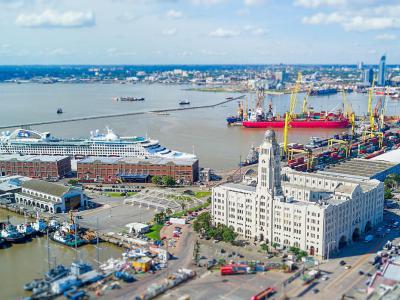
Montevideo is the capital and largest city of Uruguay, shaped by its position on the northern bank of the River Plate and by centuries of rivalry between empires, regional powers, and local movements. Long before Europeans arrived, the area was inhabited by semi-nomadic groups who lived from hunting, fishing, and gathering.

The most common explanation of the name links it to early Portuguese or Spanish sailors who, upon spotting the hill overlooking the bay, referred to it as Monte vide eu, meaning “I saw a hill”.

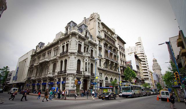
Montevideo was formally founded in 1726 by the Spanish. Its creation was a strategic move to counter Portuguese expansion from Brazil and to secure Spanish control over the River Plate. Initially a fortified military outpost, the settlement slowly grew into a port town, serving both defensive and commercial purposes. The Old City developed within its walls, with a grid of streets, religious buildings, and administrative structures typical of Spanish colonial planning.

Uruguay emerged as an independent state in 1828, and Montevideo was confirmed as its capital. Soon after, the city endured the lengthy Great Siege from 1843 to 1851, one of the defining episodes in its history, reflecting broader struggles between regional factions and foreign interests. The late 19th and early 20th centuries marked a period of strong growth and modernization. Large waves of immigrants from Italy, Spain, and other parts of Europe reshaped Montevideo’s population, culture, and architecture.

Today, Montevideo reflects its layered past: a port city shaped by empire, migration, and resilience, with a distinct identity rooted in both European influence and local history.

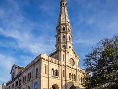
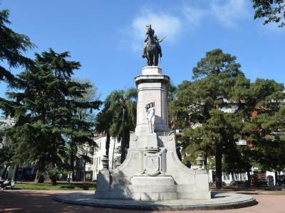
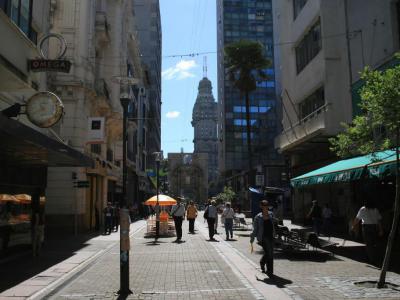
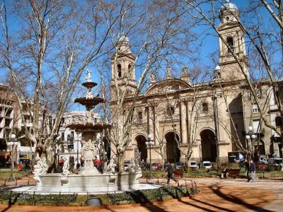
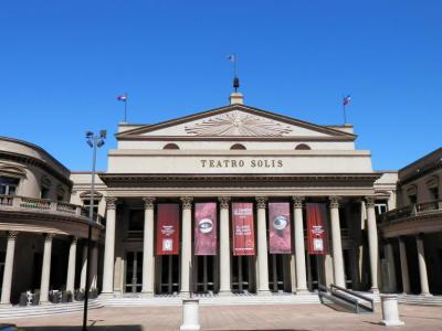
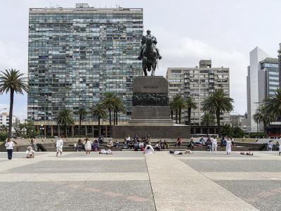
Walking through Montevideo’s Old Town, visitors move between lively plazas and historic landmarks. Independence Square marks the transition into the Old Town, framed by landmark buildings and leading toward the elegant Solís Theater, the city’s main opera house. Nearby, the Metropolitan Cathedral of Montevideo anchors the old quarter with its sober neoclassical facade.

Follow the streets, plazas, and waterfronts of Montevideo, and you’ll soon see why Darwin called it a city in perpetual expectation, every corner promises a new story waiting to be discovered.
How it works: Download the app "GPSmyCity: Walks in 1K+ Cities" from Apple App Store or Google Play Store to your mobile phone or tablet. The app turns your mobile device into a personal tour guide and its built-in GPS navigation functions guide you from one tour stop to next. The app works offline, so no data plan is needed when traveling abroad.

Download The GPSmyCity App

Montevideo Old Town Walking Tour Map

Guide Name: Montevideo Old Town Walking Tour
Guide Location: Uruguay » Montevideo (See other walking tours in Montevideo)
Guide Type: Self-guided Walking Tour (Sightseeing)
# of Attractions: 11
Tour Duration: 2 Hour(s)
Travel Distance: 2.5 Km or 1.6 Miles
Author: jenny
Sight(s) Featured in This Guide:
  • Port of Montevideo Public Terminal
  • Mercado del Puerto (Port Market)
  • Iglesia de San Francisco (San Francisco Church)
  • Plaza Zabala (Zabala Square)
  • Peatonal Sarandí (Sarandí Street)
  • Catedral de Montevideo (Metropolitan Cathedral)
  • Montevideo Cabildo (Old Montevideo City Hall)
  • Teatro Solis (Solis Theatre)
  • Plaza Independencia (Independence Square)
  • Palacio Salvo (Salvo Palace)
  • Rambla de Montevideo (Rambla of Montevideo)
1
Port of Montevideo Public Terminal

1) Port of Montevideo Public Terminal

The Port of Montevideo is Uruguay’s principal maritime gateway, strategically positioned on the northern bank of the River Plate, within the natural shelter of Montevideo Bay. Long central to the country’s trade and development, the port continues to play a key economic role while maintaining a historical connection to the city.

The port is broadly organized into functional zones. The eastern sector handles container traffic, general cargo, and passenger vessels, including cruise ships, while the northwestern area, known as La Teja, is dedicated primarily to oil, gas, and bulk liquid operations. This division reflects Montevideo’s dual role as both a commercial port and an energy hub.

At the port entrance, visitors encounter an environment shaped by modern port architecture and industrial-scale public artworks. Visitors also encounter historical structures like the Sarandí Pier and the nearby National Hotel, which are undergoing preservation efforts amidst port expansion.

Cruise travelers benefit from the port’s proximity to the Old Town and Port Market. Just outside the port gates, the surrounding streets are lined with souvenir shops, small craft stalls, wine stores, restaurants, and boutiques offering locally made products.
2
Mercado del Puerto (Port Market)

2) Mercado del Puerto (Port Market) (must see)

The Port Market is often described as the city’s most famous gathering place for traditional food, particularly grilled meat. Despite its name, it no longer functions as a market in the usual sense. While it once operated as a true food and produce market, that role faded long ago. Today, the iron structure houses a collection of restaurants, many centered on the parrilla, Uruguay’s distinctive style of barbecue.

Its construction began in 1865 and followed a design trend popular in Europe at the time, using prefabricated iron elements inspired by 19th-century industrial architecture. After nearly three years of work, the building was inaugurated in 1868, during the presidency of Lorenzo Batlle. . From the outset, it reflected Montevideo’s ambition to present itself as a modern port city connected to global trade and design.

Over time, the Market evolved into a culinary destination. Today it is especially associated with meat-focused restaurants, reflecting Uruguay’s long-standing cattle-raising traditions and national food culture. Visitors will find classic parrillas offering cuts grilled over wood embers, often accompanied by simple side dishes and local wine. While individual restaurants come and go, the overall experience remains centered on informal, hearty dining and a lively, social atmosphere.

Architecturally, the building retains its 19th-century iron framework, giving it an industrial character rather than a colonial one, softened by constant activity and the aromas of open grills. The market is open throughout the week, with Sundays typically the busiest, when locals and visitors alike gather for long lunches that can stretch well into the afternoon.
3
Iglesia de San Francisco (San Francisco Church)

3) Iglesia de San Francisco (San Francisco Church)

The San Francisco Church occupies the site of an earlier religious building erected by the Jesuits in 1724. That original church was transferred to the Franciscan order in 1740, giving the site its enduring association with Saint Francis.

The church follows a basilica plan with three naves covered by groin vaults, a transept, and a semi-circular apse. The side aisles rise unusually high, contributing to the building’s vertical emphasis. Between the buttresses, four lower chapels are arranged along each side of the central nave. The bell tower houses a five-bell carillon, while beneath the church lies the Crypt of the Lord of Patience, one of its most distinctive devotional spaces.

Architecturally, the church is a clear example of 19th-century eclecticism, combining multiple historical styles within a single composition. Classical Greco-Roman elements coexist with medieval references: flying buttresses, a rose window, grouped Gothic-style pointed windows, and a Romanesque-inspired tower that dominates the facade. Rather than adhering to one tradition, the design reflects a period when historical styles were freely blended.

The building visible today results from a major reconstruction begun in 1864, replacing an earlier church completed in 1790. The project was led by Victor Rabu, a French-Uruguayan architect active in Montevideo during the second half of the 19th century. The reconstruction introduced a taller and more unified central nave, while refining the interior layout of the aisles and chapels.

The Crypt of the Lord of Patience remains a place of quiet devotion. Its walls are covered with written prayers and messages left by worshipers and many who were baptized in the church return later in life to this crypt.
4
Plaza Zabala (Zabala Square)

4) Plaza Zabala (Zabala Square)

Bruno Mauricio de Zabala, a Spanish military officer, played a key role in securing Spanish control of the River Plate in the early 18th century. To strengthen Spain’s presence in the region, Zabala ordered the establishment of a fortified settlement on the coast in 1726. The coastal fortress built under Zabala remained a defining feature of the site for more than a century. In 1878, during the rule of Colonel Lorenzo Latorre, the decision was made to demolish the old fortifications and convert the area into a public square.

The square itself was officially inaugurated in December 1890, but without a central monument. The equestrian statue of Zabala was installed much later and inaugurated on December 27, 1931. The statue stands at the center of the square, with Zabala on horseback oriented toward the north.

The landscaped gardens surrounding the monument were designed by French landscape architect Édouard André. His plan organizes the square with radial walkways leading inward to the statue, framed by structured greenery and enclosed by ornamental iron fences and gates. The square is fully encircled by Durango Ring Road, the ring street that traces the former defensive perimeter and is named after Zabala’s birthplace.

On the southern edge of the square, facing the gardens, stands Taranco Palace, now the Museum of Decorative Arts. Together, the square, monument, and surrounding buildings mark Montevideo’s shift from fortified outpost to civic capital, visible in both layout and orientation.
5
Peatonal Sarandí (Sarandí Street)

5) Peatonal Sarandí (Sarandí Street)

Sarandí Street is the main pedestrian thoroughfare of Montevideo’s Old City, long serving as a commercial, cultural, and social axis linking the western, port-facing quarter with the city’s historic civic heart. Lined with museums, educational institutions, historic facades, cafes, and small shops, the street offers a concentrated overview of how Montevideo evolved from a fortified colonial settlement into a modern capital shaped by culture and everyday urban life.

At Sarandí 472, you pass the Dr. Pedro Figari School of Arts and Crafts. The school occupies a former 19th-century institutional building, originally constructed for public administrative use. Its architecture is sober and symmetrical, with a classically inspired facade, rusticated stonework at street level, and tall openings that reflect Italian Renaissance influences common in official buildings of the period.

Continuing east, Sarandí grows denser in cultural landmarks as it approaches the city’s historic core. At Sarandí 524, on the south side of the street, just before reaching the square, stands the Gurvich Museum, dedicated to artist José Gurvich, a key figure of the Taller Torres-García movement.

The street then opens directly onto Matriz Square, the oldest public square in Montevideo. Here, Sarandí meets the Metropolitan Cathedral of Montevideo and the Montevideo City Hall, at the corner of Juan Carlos Gómez and Sarandí. Together, these buildings mark the point where religious authority and colonial administration once shaped public life.
6
Catedral de Montevideo (Metropolitan Cathedral)

6) Catedral de Montevideo (Metropolitan Cathedral) (must see)

The Metropolitan Cathedral of Montevideo is the principal Catholic church of the city and the seat of the Archdiocese of Montevideo. Standing on Constitution Square, the site has been used for religious worship since the Spanish colonial period, with the first brick church on this location dating from 1740.

Architecturally, the cathedral is a restrained example of Colonial Neoclassicism, reflecting late-colonial tastes rather than high European academic neoclassicism. The project is traditionally attributed to Spanish architect Tomás Toribio, though, as with many colonial works, it evolved through multiple phases and hands. The main facade was completed in 1860, giving the building its present external appearance.

The interior follows a basilica plan, with a main altar, several side chapels, memorials, tombs, patterned tiled floors, and hanging chandeliers that contribute to its sober, dignified atmosphere. Along the right-hand side of the nave, in a dedicated side chapel, stands a image of Our Lady of the Thirty-Three, Patroness of Uruguay. The title refers to the Thirty-Three Orientals who led the independence movement in 1825.

The cathedral also serves as a burial place for a number of notable figures from Uruguay’s history, including clergy, military leaders, and political personalities, reinforcing its role as both a religious and national monument. The building inspired the Paraguayan guitarist and composer Agustín Pío Barrios, who composed the work “La Catedral” after visiting Montevideo.

The cathedral houses artworks by prominent Uruguayan artists, including José Belloni and Juan Manuel Blanes, among others. Its bicentennial was celebrated in 2004, marking two hundred years since its consecration and underscoring its enduring place in Montevideo’s religious, cultural, and historical landscape.
7
Montevideo Cabildo (Old Montevideo City Hall)

7) Montevideo Cabildo (Old Montevideo City Hall)

The Montevideo City Hall was originally conceived as the city’s main administrative and judicial center. The building is a two-story colonial structure, typical of late Spanish colonial civic architecture.

Before its construction, Montevideo’s municipal council met in the private residence of Captain Pedro Gronardo. In 1737, the decision was made to erect a dedicated headquarters for the City Hall. However, due to prolonged debates, design changes, and interruptions linked to the city’s rapid development in the late 18th century, construction was repeatedly delayed. Work on the present building finally began in 1804, and it became operational in the early 19th century.

Throughout the 19th and early 20th centuries, the City Hall was the setting for many decisive political, judicial, and social events. On July 18, 1830, Uruguay’s first Constitution was signed in one of its chambers. At different moments, the building served as the seat of the national legislature and also functioned as a prison.

After the inauguration of the Legislative Palace in 1925, which became the permanent home of Uruguay’s Parliament, the Cabildo ceased to function as a legislative space. The Ministry of Foreign Affairs later occupied the building. In 1939, it became the backdrop for intense diplomatic negotiations following the arrival of the German battleship Admiral Graf Spee.

In the 1950s, the building returned to municipal administration and was officially converted into a museum in September 1958. Today, it is known as the Cabildo Historical Museum. Its collections include antiques, paintings, historical documents, period costumes, and objects related to Montevideo’s civic life.
8
Teatro Solis (Solis Theatre)

8) Teatro Solis (Solis Theatre) (must see)

The Solís Theater was conceived as a grand venue for opera and the performing arts, intended to place Montevideo among the great cultural capitals of the 19th century. It opened in 1856 and is considered Uruguay’s oldest operating theater. The building is named after Juan Díaz de Solís, the 16th-century Spanish explorer traditionally credited as the first European to navigate the River Plate region.

Between 1998 and 2004, the Solís Theater underwent a comprehensive restoration and modernization. The project focused on structural reinforcement, stage technology, audience comfort, and acoustics, while preserving the historic character of the building. The renovation included contemporary design elements by Philippe Starck, most notably in interior features rather than structural columns, and the acoustic design was carried out by the French firm Avel Acoustique.

Architecturally, the theater is best described as Neoclassical, inspired by Italian opera houses of the 18th and 19th centuries. The facade features a Greek-style portico with Corinthian columns, while the interior follows an elliptical plan, echoing the horseshoe-shaped auditoriums typical of traditional Italian theaters. Comparisons are often made to major European opera houses, though the Solís maintains a distinctly local interpretation of the style.

Today, the Solís Theater serves as a leading venue for opera, ballet, theater, symphonic concerts, and contemporary performances. Performances are generally held in the evenings, while guided tours allow visitors to explore the auditorium, stage areas, and public spaces during the day. The theater remains a central reference point for Montevideo’s cultural life, balancing historical prestige with a modern performance program.
9
Plaza Independencia (Independence Square)

9) Plaza Independencia (Independence Square) (must see)

José Gervasio Artigas, the national hero of Uruguayan independence, was deeply influenced by Enlightenment and revolutionary thinkers such as Thomas Paine, Thomas Jefferson, and Jean-Jacques Rousseau. Although he is widely regarded as the father of Uruguayan nationhood, Artigas spent his final years in exile in Paraguay, where he died in 1850. His remains were later repatriated and today rest in the Artigas Mausoleum, located beneath Independence Square, at the symbolic center of Montevideo.

Independence Square was first conceived in the 1830s by Italian architect Carlo Zucchi, who drew inspiration from large European civic squares. The space was later redesigned in the mid-19th century by Bernardo Poncini, a Swiss architect and sculptor. In the center of the square stands the equestrian statue of Artigas, created by Italian sculptor Angelo Zanelli and inaugurated in 1923. Beneath the monument lies the underground mausoleum, accessed by stairways descending from the base of the statue.

Standing in the square, the western side is marked by the Citadel Gate, the last surviving entrance of the colonial fortifications. Facing east, the square opens directly onto 18 de Julio Avenue, Montevideo’s principal boulevard, with the Salvo Palace rising prominently at its beginning. Along the southern edge of the square, stands the Estévez Palace, a 19th-century presidential residence now used for ceremonial functions; immediately behind and adjoining it rises the glass-and-steel Executive Tower, the current workplace of the President of Uruguay.
10
Palacio Salvo (Salvo Palace)

10) Palacio Salvo (Salvo Palace)

The Salvo Palace was designed by Italian architect Mario Palanti and inaugurated in 1928. Rising to approximately 95 meters, it was among the tallest buildings in South America at the time of its completion and remains one of the most prominent structures on Montevideo’s skyline.

Palanti drew conceptual inspiration from Dante Alighieri’s Divine Comedy, an idea he also explored in his earlier Barolo Palace in Buenos Aires. While the symbolic division of the building into “Hell”, “Purgatory”, and “Heaven” is not formally labeled within the structure, the vertical progression of spaces and decorative elements reflects this allegorical narrative, culminating in the tower and lighthouse-like crown.

Architecturally, Salvo Palace is best described as eclectic, blending Art Deco massing with Neoclassical, Gothic, and Renaissance-inspired details. Its ornate facade, varied textures, and vertical emphasis reflect the optimism and ambition of Montevideo during the early 20th century, a period marked by economic growth and cultural confidence. Over time, the building has become a visual symbol of the city and an enduring reference point in its urban identity.

Today, Salvo Palace contains a mix of private apartments, offices, and ground-floor commercial spaces, including cafes and small shops. It also houses the Museum of Tango, dedicated in part to La Cumparsita, one of the most famous tangos in the world, composed in Montevideo. The museum highlights the city’s role in the development of tango and explores Uruguay’s contribution to the genre’s history and international reach.
11
Rambla de Montevideo (Rambla of Montevideo)

11) Rambla de Montevideo (Rambla of Montevideo) (must see)

The Rambla of Montevideo is a long coastal promenade that traces the shoreline of the River Plate along the southern and eastern edges of the city. Stretching for approximately 22 to 24 kilometers, it forms one of the longest continuous urban waterfront promenades in the world. The Rambla borders a sequence of well-known urban beaches, including Ramírez, Pocitos, Buceo, Malvín, and Carrasco. Walking, jogging, cycling, sunbathing, and socializing are daily rituals here.

The Rambla passes by many squares along its way and one of them is the Spain Square. Here you are on a widened section of the Rambla where the coastal road, pedestrian paths, and waterfront align in a clear, open layout. The square sits directly beside the shoreline, with uninterrupted views across the River Plate. From here, the Rambla continues in both directions with broad sidewalks, traffic lanes, and low stone barriers separating the pedestrian areas from the water.

If you walk west, you soon encounter the Tribute to Isabella the Catholic, a commemorative monument reflecting early-20th-century views on Spain’s role in the history of the Americas. Nearby stands the Old Sewer Vent, a small piece of urban infrastructure, built as part of Montevideo’s early modern sanitation system. Heading east instead, you reach Argentine Republic Square, a green waterfront square, followed by Mauá Waterfront Space, a former port area.

Deeply embedded in Montevideo’s identity, the Montevideo Rambla has been declared a National Historic Monument, recognized for its role as a defining urban feature shaped by daily use, coastal geography, and long-term city planning.

Walking Tours in Montevideo, Uruguay

Create Your Own Walk in Montevideo

Create Your Own Walk in Montevideo

Creating your own self-guided walk in Montevideo is easy and fun. Choose the city attractions that you want to see and a walk route map will be created just for you. You can even set your hotel as the start point of the walk.
Prado District Walking Tour

Prado District Walking Tour

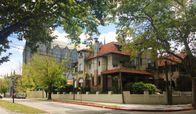
The Prado is one of Montevideo’s oldest and most historically layered districts, shaped by a long transition from rural outskirts to a residential and cultural area closely linked to the city’s elite and intellectual life. The name Prado comes from the Spanish word for “meadow” or “pasture”, reflecting the area’s original landscape: open grasslands along the Miguelete Stream.

...  view more

Tour Duration: 2 Hour(s)
Travel Distance: 3.6 Km or 2.2 Miles