

Rambla de Montevideo (Rambla of Montevideo), Montevideo (must see)
The Rambla of Montevideo is a long coastal promenade that traces the shoreline of the River Plate along the southern and eastern edges of the city. Stretching for approximately 22 to 24 kilometers, it forms one of the longest continuous urban waterfront promenades in the world. The Rambla borders a sequence of well-known urban beaches, including Ramírez, Pocitos, Buceo, Malvín, and Carrasco. Walking, jogging, cycling, sunbathing, and socializing are daily rituals here.
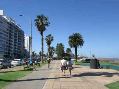
The Rambla passes by many squares along its way and one of them is the Spain Square. Here you are on a widened section of the Rambla where the coastal road, pedestrian paths, and waterfront align in a clear, open layout. The square sits directly beside the shoreline, with uninterrupted views across the River Plate. From here, the Rambla continues in both directions with broad sidewalks, traffic lanes, and low stone barriers separating the pedestrian areas from the water.
If you walk west, you soon encounter the Tribute to Isabella the Catholic, a commemorative monument reflecting early-20th-century views on Spain’s role in the history of the Americas. Nearby stands the Old Sewer Vent, a small piece of urban infrastructure, built as part of Montevideo’s early modern sanitation system. Heading east instead, you reach Argentine Republic Square, a green waterfront square, followed by Mauá Waterfront Space, a former port area.
Deeply embedded in Montevideo’s identity, the Montevideo Rambla has been declared a National Historic Monument, recognized for its role as a defining urban feature shaped by daily use, coastal geography, and long-term city planning.
Want to visit this sight? Check out these Self-Guided Walking Tours in Montevideo. Alternatively, you can download the mobile app "GPSmyCity: Walks in 1K+ Cities" from Apple App Store or Google Play Store. The app turns your mobile device to a personal tour guide and it works offline, so no data plan is needed when traveling abroad.
Download The GPSmyCity App
Rambla de Montevideo (Rambla of Montevideo) on Map
Sight Name: Rambla de Montevideo (Rambla of Montevideo)
Sight Location: Montevideo, Uruguay (See walking tours in Montevideo)
Sight Type: Attraction/Landmark
Guide(s) Containing This Sight:
Sight Location: Montevideo, Uruguay (See walking tours in Montevideo)
Sight Type: Attraction/Landmark
Guide(s) Containing This Sight:
Nearby Sights


Walking Tours in Montevideo, Uruguay

Create Your Own Walk in Montevideo
Creating your own self-guided walk in Montevideo is easy and fun. Choose the city attractions that you want to see and a walk route map will be created just for you. You can even set your hotel as the start point of the walk.
Prado District Walking Tour
The Prado is one of Montevideo’s oldest and most historically layered districts, shaped by a long transition from rural outskirts to a residential and cultural area closely linked to the city’s elite and intellectual life. The name Prado comes from the Spanish word for “meadow” or “pasture”, reflecting the area’s original landscape: open grasslands along the Miguelete Stream.
... view more
Tour Duration: 2 Hour(s)
Travel Distance: 3.6 Km or 2.2 Miles
... view more
Tour Duration: 2 Hour(s)
Travel Distance: 3.6 Km or 2.2 Miles
Montevideo Old Town Walking Tour
In Charles Darwin's journals, who visited Montevideo in the 1830s during the voyage of the Beagle, he observed that the city felt like “a town living in a state of perpetual expectation”, shaped by sieges, trade, and uncertainty.
Montevideo is the capital and largest city of Uruguay, shaped by its position on the northern bank of the River Plate and by centuries of rivalry between... view more
Tour Duration: 2 Hour(s)
Travel Distance: 2.5 Km or 1.6 Miles
Montevideo is the capital and largest city of Uruguay, shaped by its position on the northern bank of the River Plate and by centuries of rivalry between... view more
Tour Duration: 2 Hour(s)
Travel Distance: 2.5 Km or 1.6 Miles