Custom Walk in Santorini, Greece by wkwleung_f8cc79 created on 2026-04-25
Guide Location: Greece » Santorini
Guide Type: Custom Walk
# of Sights: 11
Tour Duration: 11 Hour(s)
Travel Distance: 30.8 Km or 19.1 Miles
Share Key: MCKKW
Guide Type: Custom Walk
# of Sights: 11
Tour Duration: 11 Hour(s)
Travel Distance: 30.8 Km or 19.1 Miles
Share Key: MCKKW
How It Works
Please retrieve this walk in the GPSmyCity app. Once done, the app will guide you from one tour stop to the next as if you had a personal tour guide. If you created the walk on this website or come to the page via a link, please follow the instructions below to retrieve the walk in the app.
Retrieve This Walk in App
Step 1. Download the app "GPSmyCity: Walks in 1K+ Cities" on Apple App Store or Google Play Store.
Step 2. In the GPSmyCity app, download(or launch) the guide "Santorini Map and Walking Tours".
Step 3. Tap the menu button located at upper right corner of the "Walks" screen and select "Retrieve custom walk". Enter the share key: MCKKW
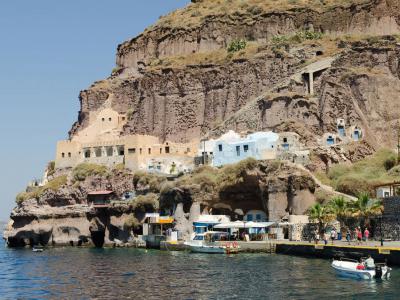
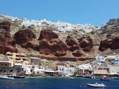
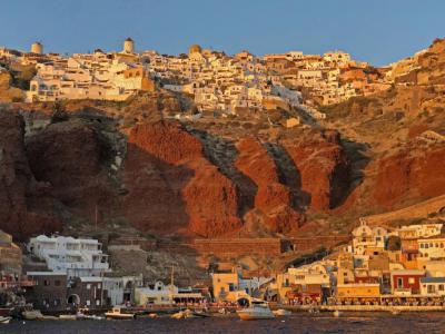
1) Santorini Old Harbor
Santorini’s Old Harbor owes its existence to the island’s volcanic formation, shaped primarily by the great Bronze Age eruption around the 16th century BCE. For centuries, it functioned as the island’s main maritime access point, serving small cargo vessels and passenger boats until modern port facilities were developed elsewhere. Today, it no longer handles large-scale traffic but remains active as a tender harbor for cruise ships.
Because the caldera drops steeply into deep water, cruise ships cannot dock directly. Instead, passengers are transferred to the Old Harbor by tender boats, which ferry them ashore from anchored ships. Historically, access between the harbor and Fira was possible only via a steep zigzagging path of approximately 580 steps, carved into the cliff face and still visible today.
Modern visitors can reach the upper town by cable car, introduced in the late 20th century. The ride takes about five minutes and offers wide views over the caldera and harbor below. Donkeys, once an essential means of transport, are still present, though their use today is increasingly discouraged. For those on foot, the climb remains demanding, especially in summer heat.
The Old Harbor waterfront features a small cluster of cafes, taverns, and souvenir shops catering mainly to cruise passengers. From here, boat excursions depart to the Nea Kameni volcano and nearby hot springs, particularly during the warmer months. While the harbor can become crowded during peak cruise days, overall visitor numbers fluctuate depending on ship schedules rather than constant daily traffic.
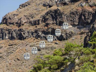
2) Santorini Cable Car
The Santorini Cable Car is a key transportation feature on the Greek island of Santorini, providing a safe and convenient means for visitors to travel from the Old Port to Fira, the island's capital. Established to address the challenges posed by the steep, 600-step climb from the Old Port, the cable car offers an easy and charming ride with breathtaking views of the Caldera, the Aegean Sea, and the Volcano from an altitude of 220 meters.
Historically, prior to the 1970s, visitors could only ascend to Fira by foot or on mule, which was difficult for the elderly, those with mobility issues, and tourists carrying heavy luggage. With the increase in tourist and cruise ship traffic in the 1970s, a more accessible solution became necessary. Evangelos Nomikos, a ship owner and notable benefactor of Santorini, funded the construction of the cable car. The project began in the autumn of 1980 and was completed by the summer of 1982.
Capable of transporting 1200 people per hour, the gondola-style carriages seat six passengers in two rows of three, and the journey between the Old Port and Fira takes just five minutes. This rapid transit system is particularly beneficial for cruise ship passengers and those participating in volcano boat tours departing from the Old Port.
The cable car ride itself offers stunning vistas of the Aegean Sea, the Volcano, and the iconic white-washed houses perched on the Caldera cliffs. Conveniently located near the Archaeological Museum in Fira, the cable car station and ticket office are easy to find, with clear signage guiding visitors from the Orthodox Metropolitan Cathedral along the main path towards Firostefani village.
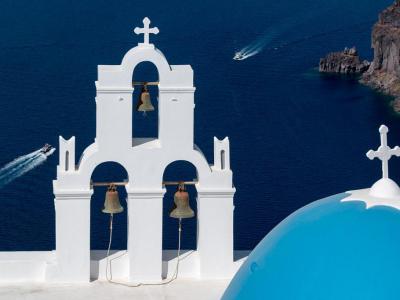
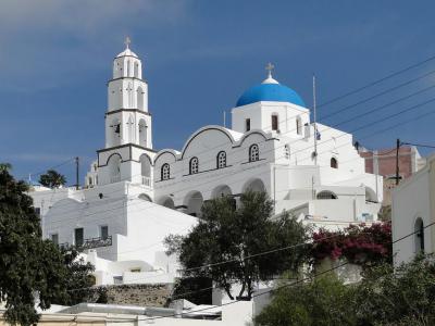
3) Three Bells of Fira (must see)
The Three Bells of Fira, officially known as the Catholic Church of the Dormition, belongs to the Greek Catholic Church and falls under the jurisdiction of the Catholic Diocese of Santorini, following the Byzantine liturgical tradition while remaining in communion with Rome.
The site has a long and layered history. In the 17th century, two small cave churches were carved into the cliff face here. As the settlement expanded and the terrain shifted, these early structures were lost. An infirmary was later built on the site and subsequently occupied by Jesuits, before the property was transferred to the Catholic authorities. The present-day church was constructed in 1757, forming the core of the structure seen today.
The church suffered serious damage during the 1956 Amorgos earthquake. Extensive restoration followed, giving the building its current appearance. Architecturally modest in scale, its visual impact comes from its setting and composition: whitewashed walls, a vivid blue dome, and a freestanding bell tower crowned with three bells. The bell tower, positioned slightly apart from the church itself, overlooks the caldera and the Nea Kameni volcanic islet.
The church is dedicated to the Dormition of the Virgin Mary, celebrated on 15 August, which remains its principal feast day. On this occasion, religious services and observances are held in keeping with Byzantine Catholic tradition.
Today, the Three Bells of Fira functions both as an active place of worship and as one of the island’s most photographed viewpoints. Its best-known view is from the clifftop viewpoint and parking area above the church, from where the dome and bell tower are seen framed against the sea and sky.
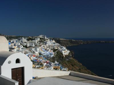
4) Firostefani Central Square
Firostefani Central Square in Santorini offers a quaint and charming spot in the picturesque neighborhood of Firostefani, just a short distance from the bustling town of Fira. Although it might not resemble a typical town square, this small area serves as a delightful gathering spot right next to the main road, making it an excellent stop for both locals and visitors.
This central square is surrounded by the quintessential white-washed buildings adorned with vibrant bougainvillea, reflecting the traditional Greek architectural style that Santorini is famous for. Its prime location on the edge of the caldera provides visitors with breathtaking panoramic views of the volcanic landscape and the deep blue Aegean Sea, making it a perfect vantage point for enjoying the island's natural beauty.
The area around Firostefani Central Square is brimming with a variety of eateries, including local cafés and restaurants that offer delicious local cuisine and a great selection of wines and other beverages. It's an ideal spot for those looking to grab a quick bite or enjoy a leisurely meal while soaking in the scenic views.
Tourists can also explore the narrow, cobbled streets lined with boutique shops, local tavernas, and charming cafes, adding to the square's laid-back ambiance. The square often hosts local events and festivals, providing a glimpse into the authentic culture of the island.
Firostefani Central Square's proximity to notable attractions, such as the Old Port of Fira and Skala, as well as cultural landmarks like the Agios Gerasimos Church and the Archaeological Museum of Thera, makes it a convenient and appealing destination for those seeking both relaxation and cultural exploration on the beautiful island of Santorini.
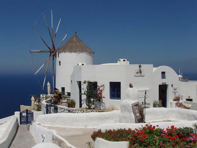
5) Windmill of Oia
The windmills of Oia were originally part of the island’s agricultural infrastructure, built to harness the strong winds for grinding grain. In this western section of the village, often referred to as “Two Mill Oia”, two historic windmills stand side by side, both of which have been restored and adapted for private accommodation. Their distinctive silhouettes and exposed position along the caldera rim have made them closely associated with sunset viewing, although interior access is limited to guests when occupied.
Inside, the former industrial spaces have been reconfigured for residential use, with rooms arranged vertically and linked by narrow stone staircases that follow the original cylindrical form of the mills. While the interiors remain private, the large exterior terraces are a defining feature. These elevated decks provide a secluded vantage point for watching the sunset.
Santorini’s persistent winds once supported the widespread use of windmills across the island. Around 60 to 70 windmills are known to have operated historically, primarily for grinding grain into flour. The earliest examples date to the late medieval period, with most surviving structures built between the 17th and 19th centuries. Often connected to local bakeries, these windmills played a central role in everyday food production before industrial milling gradually rendered them obsolete.
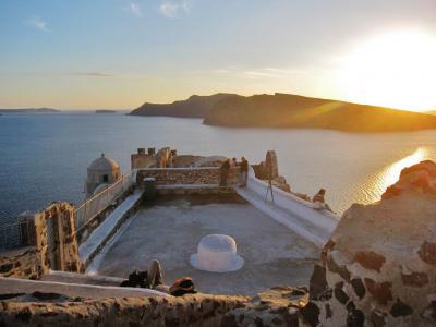
6) Oia Castle (must see)
Oia Castle, often identified as the Castle of Saint Nicholas, is a late-15th-century fortified site and one of the best-known historical landmarks in Oia today. Its ruins remain a major gathering point, especially in the evening, because the exposed cliffside position offers wide caldera views.
The castle was developed during the period of Venetian domination as part of Santorini’s network of fortified settlements, created to guard against pirate raids in the Aegean. Raids could involve theft and the taking of captives, which helps explain why local settlement patterns favored compact building and rapid retreat to defensible points. Some accounts also describe residents hiding valuables in pits beneath buildings within the fortified area; this is often repeated in local narratives about the site.
Within the castle complex, there were residences associated with the Venetian rulers, and the high position functioned as a lookout over sea routes. The stronghold is often said to have been taken by Ottoman forces in 1577, while wider histories place the Ottoman conquest of Santorini within the broader annexation of the Cyclades in 1579, so it’s best understood as a late-16th-century transition from Venetian to Ottoman control.
The site was severely damaged in the 1956 earthquake, when large sections of the fortifications and parts of the surrounding settlement collapsed down the cliffs. What remains today are fragments of walls and the base of defensive elements, but the viewpoint is still exceptional. From the ruins, visitors can clearly see the volcanic islets of Nea Kameni and Palea Kameni in the center of the caldera, as well as the nearby island of Thirasia to the northwest.
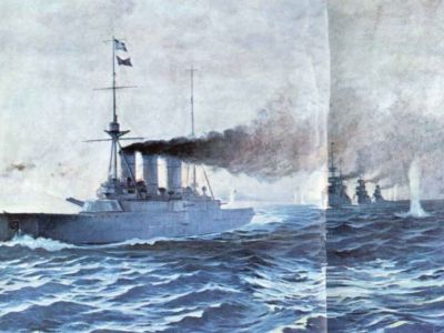
7) Naval Maritime Museum
The Naval Maritime Museum is housed in a historic two-story mansion dating to the 19th century, originally built as a captain’s house. Its setting reflects Oia’s former prosperity during a period when maritime trade shaped much of the village’s economy and social structure.
Santorini played an important role in regional maritime trade rather than formal naval history. During the 19th and early 20th centuries, island-owned sailing vessels operated widely across the Aegean, the eastern Mediterranean, and as far as the Black Sea. These ships were primarily involved in commercial exchange, exporting local products such as wine and pumice stone, while importing essential goods including grain, timber, fabrics, and other materials needed for daily life on the island.
The museum’s collection focuses on traditional seafaring and merchant shipping. Displays include navigational instruments such as maps, compasses, sextants, log meters, and anchors, illustrating the practical tools used aboard sailing vessels. A small research library complements the exhibits, containing books, documents, nautical charts, logbooks, and shipping records related to local maritime activity.
Additional exhibits feature detailed ship models, sailors’ uniforms, portraits of local captains, and carved figureheads. An extensive collection of paintings depicts historic sailing ships, while rare photographs provide visual insight into everyday life during Oia’s peak shipping era. Together, these materials present a focused picture of the island’s maritime heritage, emphasizing trade, navigation, and the people who sustained Santorini’s seafaring traditions.
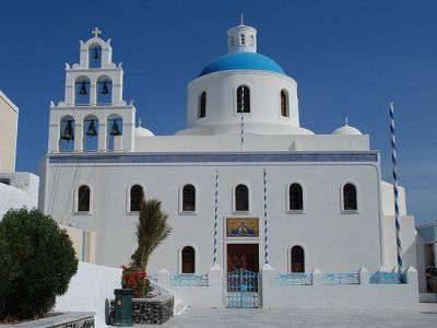
8) Church of Panagia Platsani
The Church of Panagia Platsani is closely tied to the history of the former castle settlement. The original church stood within the walls of Oia Castle, but after the devastating earthquake of 1956, it was relocated. Architecturally, it follows the Cycladic style, with whitewashed walls, a blue dome, arched openings, and a prominent bell tower.
According to local tradition, the church’s origins are linked to the discovery of a miraculous icon of the Virgin Mary, found floating in the sea by a fisherman. When the icon was brought to a safe place, it was said to have mysteriously returned overnight to the castle area. This was repeated several times, and the townspeople interpreted it as a sign that the Virgin wished her place of worship to stand there. As a result, a church was built at that location, overlooking the sea, symbolically watching over sailors and vessels passing below.
As you enter from the main square, a large, prominent golden mosaic icon of the Virgin Mary is located directly above the main door. Inside, visitors will find the revered icon of Panagia, along with votive offerings left by sailors and families, reflecting Oia’s long maritime tradition. As you stand in the nave facing the iconostasis, the icon of the Virgin Mary is positioned to the right of the Royal Doors, opposite the icon of Christ. Look closely at the silver ex-votos shaped like ships, the hanging lamps, and the framed inscriptions expressing gratitude for safe journeys.
Step outside into the small square in front of the church, which serves as a central gathering point in Oia. Set into the pavement of the square is a circular marble mosaic, added during post-1956 reconstruction, depicting Santorini and its caldera, including the volcanic islets at the centre. Facing the church, the view opens toward the sea, reinforcing the long-held belief that the Virgin watches over passing vessels and those who travel by water.
9) Agios Nikolaos Monastery
Located in the stunning and blue waters of the Aegean Sea is the Agios Nikolaos Monastery. This female convent is located between the villages of Firostefani and Imerovogli in Santorini. It is dedicated to saints Agios Panteleimon, Agios Nikolaos, and Zoodochos Pigi, and was established by the Gizi family in 1651. Prior to its current use, it was a private family chapel.
The design of the nunnery reflects the clean and simple lines of Cycladic style, while the interior of the edifice features beautiful 17th century artwork and spectacular golden icons. Two museums, folklore and ecclesiastical, are also located on the property.
Each year on August 15th, locals come here to celebrate the religious festival the Feast of the Assumption of the Virgin Mary. After church services, locals and visitors celebrate the holiday with food, song, and dance. Visitors will enjoy viewing the handmade textiles that the nuns make, using hand looms.
10) Armeni Port of Oia
Armeni Port, nestled below the picturesque village of Oia on the northwest side of Santorini, is a quaint and historic harbor offering stunning views of the caldera, the volcanic islands, and the nearby island of Therasia. Believed to be the oldest port in this region of the island, Armeni once thrived as the main harbor of Oia, supporting wine trade and fishing activities. Large ships would anchor offshore, with sailors using small boats, known as "Lantzes," to reach the port.
Accessing Armeni can be somewhat challenging, particularly in the summer months. Visitors have three main options: a boat ride from Ammoudi Bay, a walk down 291 steep steps, or a mule ride to navigate the descent from Oia. Despite the effort required to reach Armeni, the serene environment is well worth the journey.
Today, Armeni is a peaceful retreat featuring a few whitewashed houses, a traditional tavern, and a concrete pier where small yachts and boats can moor. The harbor, although no longer bustling with trade, provides an idyllic setting for relaxation. The Tavern by the Sea offers savory local dishes, enhancing the experience with its serene ambiance and spectacular views.
The small beach at Armeni is ideal for swimming and wall diving, boasting deep, crystalline waters and volcanic pebbles. Though unorganized and lacking facilities, its unspoiled nature adds to the charm and natural beauty of the landscape. A diving center is also available for those interested in exploring the underwater scenery. As swimmers enjoy the clear waters, they are treated to awe-inspiring views of the caldera cliffs and the captivating settlement of Oia above, creating a thrilling and overwhelming experience.
11) Órmos Ammoúdi (Amoudi Bay)
Amoudi Bay is a small inlet below Oia that attracts visitors for its clear blue waters and traditional harbor setting. The calm sea makes it suitable for swimming and small boats, and the bay is a frequent stopping point for vessels heading toward nearby Thirasia, a small island, or the rock-cut Church of the Seven Holy Youths, which lies along the coast beyond the harbor.
The bay is reached on foot by descending just over 200 steps from Oia, a well-known route that links the clifftop village with the water below. From the harbor, the caldera walls rise sharply overhead, while the open sea frames views that are especially distinctive late in the day. Sunsets are widely appreciated here, though the bay is primarily valued for its light, color, and proximity to the water rather than panoramic viewpoints.
A small hotel, a few cafes, and several fish taverns line the waterfront. The taverns are particularly known for serving fresh seafood brought in daily by local fishermen, maintaining a direct connection to the bay’s working-harbor character. The rocky shoreline nearby is popular for swimming; locals often recommend the rocks beyond the small lighthouse area as one of the better spots, especially away from the main jetty.
