

Garrison Historic Area, Bridgetown
The Garrison Historic Area, commonly referred to as "The Garrison," is a significant district in Bridgetown, located about two miles south of Heroes Square and just west of Hastings in the Christ Church parish. This area, once a key British military base, played a crucial role in Barbados' colonial history and is now home to several well-preserved historical sites.
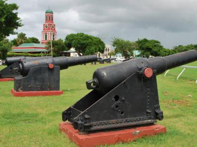
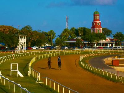
At the heart of the district lies the Garrison Savannah, a 30-acre parade ground that has served as a horse racetrack since the mid-18th century when British regiment troops and prominent Barbadian elites introduced the sport. The tradition continues today, making it one of the island’s most cherished sporting venues.
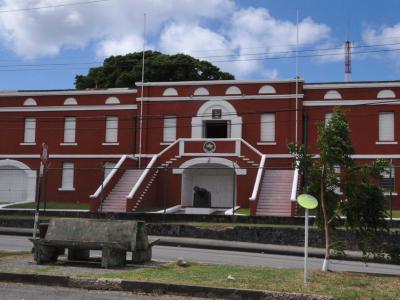
The area also houses Saint Ann’s Fort, the headquarters of the Barbados Defence Force (BDF), which stands to the west of Highway 7, the road that bisects the district. During the 18th and 19th centuries, the Garrison was the primary military headquarters for British forces in the Caribbean, particularly the British West India Regiment.
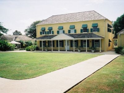
One of its most notable landmarks is the George Washington House, located in the Bush Hill section. This restored residence hosted George Washington for six weeks in 1751 while he accompanied his ailing brother. It remains a key historical attraction, offering insight into the island’s ties to American history.
Beyond military heritage, the Garrison holds a place in Barbados' modern history-on 30 November 1966, the site witnessed the ceremonial lowering of the Union Flag and the raising of the Barbadian flag, marking the island’s independence from Britain.
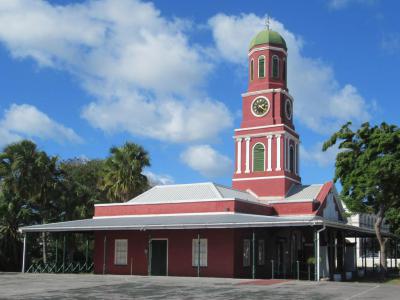
Several other historic buildings remain in the district, including former barracks, prison cells, and the Barbados Museum, which provides deeper insight into the island’s colonial past. Today, the Garrison Historic Area stands as a UNESCO World Heritage Site, blending military history, colonial architecture, and national pride into a must-visit destination in Bridgetown.
At the heart of the district lies the Garrison Savannah, a 30-acre parade ground that has served as a horse racetrack since the mid-18th century when British regiment troops and prominent Barbadian elites introduced the sport. The tradition continues today, making it one of the island’s most cherished sporting venues.
The area also houses Saint Ann’s Fort, the headquarters of the Barbados Defence Force (BDF), which stands to the west of Highway 7, the road that bisects the district. During the 18th and 19th centuries, the Garrison was the primary military headquarters for British forces in the Caribbean, particularly the British West India Regiment.
One of its most notable landmarks is the George Washington House, located in the Bush Hill section. This restored residence hosted George Washington for six weeks in 1751 while he accompanied his ailing brother. It remains a key historical attraction, offering insight into the island’s ties to American history.
Beyond military heritage, the Garrison holds a place in Barbados' modern history-on 30 November 1966, the site witnessed the ceremonial lowering of the Union Flag and the raising of the Barbadian flag, marking the island’s independence from Britain.
Several other historic buildings remain in the district, including former barracks, prison cells, and the Barbados Museum, which provides deeper insight into the island’s colonial past. Today, the Garrison Historic Area stands as a UNESCO World Heritage Site, blending military history, colonial architecture, and national pride into a must-visit destination in Bridgetown.
Want to visit this sight? Check out these Self-Guided Walking Tours in Bridgetown. Alternatively, you can download the mobile app "GPSmyCity: Walks in 1K+ Cities" from Apple App Store or Google Play Store. The app turns your mobile device to a personal tour guide and it works offline, so no data plan is needed when traveling abroad.
Download The GPSmyCity App
Garrison Historic Area on Map
Sight Name: Garrison Historic Area
Sight Location: Bridgetown, Barbados (See walking tours in Bridgetown)
Sight Type: Attraction/Landmark
Sight Location: Bridgetown, Barbados (See walking tours in Bridgetown)
Sight Type: Attraction/Landmark
Nearby Sights
Walking Tours in Bridgetown, Barbados

Create Your Own Walk in Bridgetown
Creating your own self-guided walk in Bridgetown is easy and fun. Choose the city attractions that you want to see and a walk route map will be created just for you. You can even set your hotel as the start point of the walk.
Bridgetown Introduction Walking Tour
Bridgetown is the largest city on the island of Barbados. It was founded on the shores of Carlisle Bay, a cove on the southwest coast. The harbor is the natural location for ships to anchor, and Barbados is one of the first landfall points after crossing the Atlantic from Europe.
Originally, the island of Barbados was visited by various Amerindian tribes. Evidence has shown that permanent... view more
Tour Duration: 1 Hour(s)
Travel Distance: 1.7 Km or 1.1 Miles
Originally, the island of Barbados was visited by various Amerindian tribes. Evidence has shown that permanent... view more
Tour Duration: 1 Hour(s)
Travel Distance: 1.7 Km or 1.1 Miles
Garrison Historic Area Walking Tour
St. Ann's Garrison, more commonly known simply as "The Garrison", is a small district in Barbados situated some 2 miles south of Heroes Square in the capital-city of Bridgetown.
This historic area is dominated by a horse racetrack, located on the 30 acre parade ground called the Garrison Savannah. Here, in the mid 18th century, wealthy prominent Barbadians and regiment troops... view more
Tour Duration: 1 Hour(s)
Travel Distance: 1.7 Km or 1.1 Miles
This historic area is dominated by a horse racetrack, located on the 30 acre parade ground called the Garrison Savannah. Here, in the mid 18th century, wealthy prominent Barbadians and regiment troops... view more
Tour Duration: 1 Hour(s)
Travel Distance: 1.7 Km or 1.1 Miles