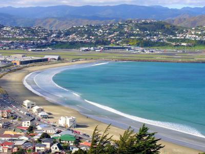


Lyall Bay, Wellington
Lyall Bay, situated on the south side of the Rongotai isthmus in Wellington, is both a bay and a suburb known for its vibrant community and natural beauty. Renowned as a popular surf beach, Lyall Bay features a distinctive breakwater at its eastern end, making it a sought-after location for surf lifesaving championships. The bay supports two surf lifesaving clubs, underscoring its reputation as a safe and popular swimming destination. However, the beach today is only two-thirds of its original size due to the construction of Wellington International Airport, which claimed the eastern third.
The suburb encompasses most of the southern half of the Rongotai isthmus, with Wellington International Airport and a small adjacent industrial area typically associated with Rongotai. The area was initially named Maranui in 1896 by H D Crawford and H M Hayward, who envisioned a new township at the bay. Lyall Bay's geographical history is fascinating, having likely been the ancient mouth of the Hutt River. The landform as it exists today was shaped by geological activity, including the significant 1855 Wairarapa earthquake.
Predominantly residential, Lyall Bay also boasts Wellington's largest beach, part of the Southern Walkway, and the Southern Headlands Reserve. The suburb is bordered to the southwest by Te Raekaihau Point, marking the separation from Houghton Bay. Amenities in Lyall Bay include a primary school (Lyall Bay School), a Playcentre, a lawn bowls club, two surf clubs, and a selection of shops. It also offers convenient public transportation options, proximity to the Kilbirnie shopping center, and the Tirangi Road Airport Retail Park.
Adding to its cultural fabric, Lyall Bay is home to Fat Freddy's Drop, a band that embodies the suburb's vibrant community spirit. This diverse mix of natural beauty, sporting facilities, residential areas, and cultural elements makes Lyall Bay a unique and cherished part of Wellington.
Want to visit this sight? Check out these Self-Guided Walking Tours in Wellington. Alternatively, you can download the mobile app "GPSmyCity: Walks in 1K+ Cities" from Apple App Store or Google Play Store. The app turns your mobile device to a personal tour guide and it works offline, so no data plan is needed when traveling abroad.
Download The GPSmyCity App
Lyall Bay on Map
Sight Name: Lyall Bay
Sight Location: Wellington, New Zealand (See walking tours in Wellington)
Sight Type: Attraction/Landmark
Sight Location: Wellington, New Zealand (See walking tours in Wellington)
Sight Type: Attraction/Landmark
Walking Tours in Wellington, New Zealand

Create Your Own Walk in Wellington
Creating your own self-guided walk in Wellington is easy and fun. Choose the city attractions that you want to see and a walk route map will be created just for you. You can even set your hotel as the start point of the walk.
Wellington Introduction Walking Tour
New Zealand writer Katherine Mansfield saw Wellington as a town set at the edge of a deep harbor, with hills rising behind it and timber houses climbing into view. More than a century later, the city still feels arranged by the same forces: water, wind, slopes, and human stubbornness.
Wellington has a history shaped by harbor, migration, colonization, earthquakes, and government. Its Maori... view more
Tour Duration: 2 Hour(s)
Travel Distance: 3.6 Km or 2.2 Miles
Wellington has a history shaped by harbor, migration, colonization, earthquakes, and government. Its Maori... view more
Tour Duration: 2 Hour(s)
Travel Distance: 3.6 Km or 2.2 Miles
Historical Buildings Walking Tour
The first immigrants to New Zealand brought along their sense of style. Most of the country's first settlers, if not all of them, were Britishers; the capital city was no exception. The latter fact is duly reflected in Wellington's historical architecture. These buildings offer a glimpse into the city's past and add a great deal of charm to the cityscape. Let's take a quick... view more
Tour Duration: 2 Hour(s)
Travel Distance: 3.5 Km or 2.2 Miles
Tour Duration: 2 Hour(s)
Travel Distance: 3.5 Km or 2.2 Miles