Custom Walk in Nicosia, Cyprus by zydrunaskusas_8ba626 created on 2026-02-26
Guide Location: Cyprus » Nicosia
Guide Type: Custom Walk
# of Sights: 11
Tour Duration: 3 Hour(s)
Travel Distance: 5.1 Km or 3.2 Miles
Share Key: LU4SE
Guide Type: Custom Walk
# of Sights: 11
Tour Duration: 3 Hour(s)
Travel Distance: 5.1 Km or 3.2 Miles
Share Key: LU4SE
How It Works
Please retrieve this walk in the GPSmyCity app. Once done, the app will guide you from one tour stop to the next as if you had a personal tour guide. If you created the walk on this website or come to the page via a link, please follow the instructions below to retrieve the walk in the app.
Retrieve This Walk in App
Step 1. Download the app "GPSmyCity: Walks in 1K+ Cities" on Apple App Store or Google Play Store.
Step 2. In the GPSmyCity app, download(or launch) the guide "Nicosia Map and Walking Tours".
Step 3. Tap the menu button located at upper right corner of the "Walks" screen and select "Retrieve custom walk". Enter the share key: LU4SE
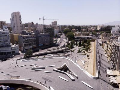
1) Eleftheria Square (Liberty Square)
Liberty Square is Nicosia's main square. It was originally called Metaxas Square after Greek Prime Minister Ioannis Metaxas and was renamed Liberty Square in 1974. Liberty Square overlooks the city's medieval Venetian walls and is home to Nicosia Town Hall. As the city's center, the square often hosts various events such as political rallies and sporting events.
In 2005, Zaha Hadid Architects won the $45 million contract to redesign Liberty Square. The new Liberty Square's inauguration finally took place in late 2021. While Nicosia is divided between Greece and Turkey, the newly designed square seeks to unite Greek and Turkish communities.
The square has a beautiful, curving pedestrian bridge that connects to the city's streets. Under the bridge, visitors will find five acres of granite paved space. The square features plenty of trees and attractive water features. The new design is an extremely forward-thinking space that connects the old dry moat and ancient city walls to today's modern communities.
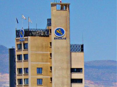
2) Shacolas Tower Museum & Observatory (must see)
The Sharcolas Tower was originally called the Manglis Tower. It was built in 1959 by Costas Manglis and housed General Engineering and Hellenic Mining offices. The Shacolas Tower was Nicosia's tallest building until 1978.
The H&M Department store takes up the tower's first five floors. The 11th floor houses the Shacolas Tower Museum & Observatory.
The Shacolas Tower Museum & Observatory features exhibits of photographs and narratives describing Nicosia. In addition, visitors can listen to a taped history, available in several languages.
The museum features a beautiful view of the city. The view extends across the mountains and the rest of the island. In addition, guests can use binoculars and telescopes to get a closer look at different landmarks and attractions.
The museum's photos and descriptions are arranged so that visitors can look at the close-up photos and then look outside and see a bird's eye view of the referenced photo.
The museum also has a small shop that sells souvenirs.
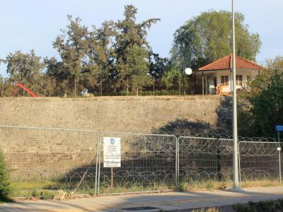
3) Zahra (Mula) Bastion. Nicosia Green Line
Zahra (Mula) Bastion is one of the five bastions located in North Nicosia (Lefkoşa) and is part of the circular defence wall that was built by the Venetian rulers in 1567 to protect the city from Ottoman invaders. Unfortunately, it failed and in 1570 the Ottomans landed in Larnaka and eventually stormed the fortifications, killing around 50,000 inhabitants. Despite this, the walls have remained in place since their construction.
The Green Line, also known as the United Nations Buffer Zone, is the border between the Greek Cypriot side and the occupied part of Cyprus. It was created on December 30, 1963, after the agreement of the Greeks, Turks, and British during the first inter-communal riots on the island in order to stop the escalation of tension between the Greek Cypriots and Turkish Cypriots. The Green Line was named as such because General Yang had drawn it with a green pencil on a map. The United Nations took over as guards of the area from March 1964.
Today, the Green Line stretches over 300 kilometers in length and divides the north (Turkish-occupied Cyprus) and south (Greek Cypriot Cyprus) parts of the island. The north part has declared itself a republic, but it is not recognized by any country in the world except for Turkey. This makes Nicosia the only divided capital in Europe. The Green Line is controlled by the soldiers of the United Nations who maintain normality in the area. It is also referred to as the Dead Zone and Ceasefire line.
In 2003, the "Turkish Cypriot government" allowed transit to the occupied areas and opened five crossing points. However, many Greek Cypriots are against this, as showing their passport in their own country is seen as a recognition of Turkish Cypriot power on the island. The Flatro (Zeytilni) Bastion on the eastern side of the Old City is occupied by Turkish, Greek Cypriot, and UN military forces, while the remaining bastions are located in North Nicosia (Lefkoşa).
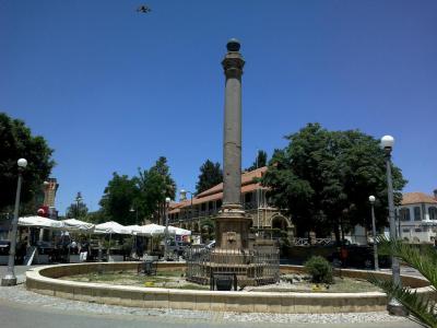
4) Atatürk Square
Ataturk Square was named in honor of Mustafa Kemal Ataturk, founding father of modern Turkey. The change was made by the municipal authority of Nicosia, led by Themistoklis Dervis. It is said Mr. Dervis was fishing for the Turkish Cypriot vote. But locals still refer to the square as "Sarayonu", meaning "the front of the palace."
The palace is gone. It was the royal French residence of the Lusignan dynasty. The Lusignans ruled Cyprus until the 15th century, when the island was annexed by Venice. The Venetians erected a granite column surmounted by a lion in front of the palace.
The column was believed to have been taken from the old Temple of Zeus at Salamis. The Ottomans arrived in 1570. They stored the column in the Sarayonu Mosque, which had been a Carmelite church. The lion of the Crusaders was replaced by a British globe when it was moved to the Square in 1915.
The fountain at the square by the law Courts was built in the Ottoman period. It is octagonal in shape with one fountain in a niche on each side. It is maintained by the Turkish Cypriot Department of Antiquities, but it ran dry long ago.
The central Law courts, the Nicosia Post Office, a police station and several banks are around the square. The old palace is gone, razed by the British. However, there is a hotel, also called Saray. You can go to its rooftop restaurant, have a drink and enjoy a view of the entire city.
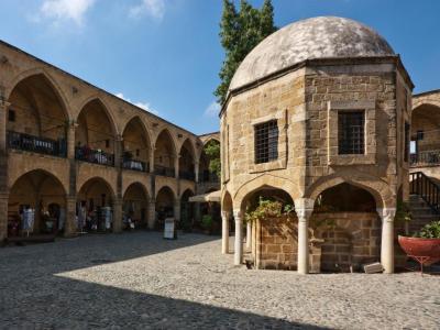
5) Büyük Han (Great Inn) (must see)
Great Inn is the largest roadside inn in Cyprus. It was built by the Ottomans in 1572, shortly after they expelled the Venetians. In the middle of the courtyard is a mosque and a fountain for religious ablutions.
The Great Inn was ordered built by Muzaffer Pasha, first ottoman governor. He got as far as the groundbreaking when he was executed. Politics was the cause, not construction. The roadside in was initially called the "New Inn." After the smaller Gambler's Inn was built it became the "Great Inn."
Under British colonial rule in 1878 the inn was restored and modified to serve as a prison. From 1903 to 1947 the place was put to its proper use as an inn. Between 1947 and 1962 it was low income housing.
The roadside inn typically has two floors and an inner courtyard. It is square shaped. The rooms of the inner courtyard have cross-vaulted colonnades. Altogether, there are 68 rooms on the two floors. The lower floor is used for commercial activity while the upper floor accommodates guests. There are ten shops behind the eastern colonnades.
The main entrance is on Asmaalti Square. There are hexagonal or octagonal shaped chimneys in each room. In the courtyard is a grave thought to be that of Muzaffer Pasha himself. This has been disputed, but who's to look?
By order of the Evkaf Administration all items sold in the Great Inn must be made by the tenants themselves. After the restorations of the 1990s, the inn has been reborn as an arts center featuring galleries and shops. In the courtyard are cafes and souvenir shops. If the Evkaf law still applies, tourists get the real thing. No Cypriot dolls made in China.
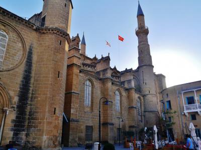
6) Selimiye Mosque (must see)
Once it was the cathedral of Saint Sophia, then it became Ayasofya. As a cathedral it makes a fine mosque. The Selimiye Mosque is the main mosque of Nicosia and the oldest remaining Gothic church in Cyprus. The Lusignan church turned mosque is built over the bones of an earlier Byzantine church. Its interior dimensions are 217 feet by 69 feet.
The mosque can hold 2500 souls at a time. It is the largest historical building in town. It was the coronation church of the kings of Cyprus. The original Byzantine church was called Hagia Sophia or "Holy Wisdom." The existence of this early church is mentioned in an 11th century manuscript and some remains continue to be found.
The foundation stone for the Cathedral of Saint Sophia was laid in 1209. The Cathedral was completed in 1249 after the arrival on the island of King Louis IX of France. The Cathedral suffered some damage from earthquakes and Genoese raids. Saint Sophia's became the center of the city with the building of the Venetian walls.
In 1570, after a 50-day siege, the city fell to the Ottomans and the Cathedral became a mosque just in time for Friday prayers. The first imam climbed to the pulpit leaning on a sword used in the siege. This custom continued until 1949. In 1954 the mosque was officially named Selimiye Mosque in memory of Selim II, Ottoman ruler during the siege.
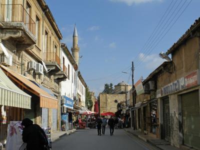
7) Arasta Street
Arasta Street extends from Eleftheria Square. It lays in a north-south direction. It is about one kilometer in length. Mostly it is within the Republic of Cyprus. At the north end one encounters the buffer zone and the green line. Here Arasta Street and Girne Caddesi enter the Turkish part of Nicosia.
The republic of Cyprus does not keep immigration checkpoints any more at the several entrances to the Turkish old city. Nevertheless it does hold identification checks on people entering from the northern, or also known as Turkish, sector.
Arasta street is narrow, pedestrian with shops jammed shoulder to shoulder. At the end of the street is the beautiful Gothic/Lusignan Selimiye Mosque and the Great Inn. The street is shaded for most of it's length by awnings and canopies. At one stretch, however, shade is provided by a flotilla of colorful umbrellas overhead.
The shops sell generally inexpensive items, including textiles, jewelry, shoes and casual footwear. There are, of course, cafes, and other watering holes for the footsore tourist.
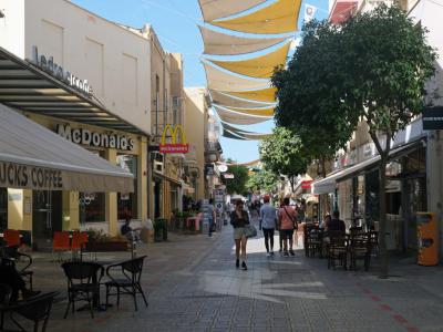
8) Ledra Street (must see)
Ledra Street is a popular shopping street named after the ancient kingdom of Ledra. In 1050 BC, Ledra was located where Nicosia is today. Ledra Street is a pedestrian-only street, so you can walk and shop without the noise and inconvenience of vehicle traffic.
The street was known as Murder Mile during the EOKA struggle in the 1950s. During this time, EOKA fighters targeted the British military along Ledra Street.
The buffer zone was established in 1974 to separate the northern Turkish-controlled part of Nicosia from the Greek-controlled southern part.
It used to have a barricade as the center of the United Nations buffer zone between the Turkish and Greek sides of the city. The barricade was removed in 2008, and now people can walk across the border.
Most of Ledra Street is on the Greek side. The Greek side features international brands, and the Turkish side has smaller boutiques. The Shacolas Tower is one of the tallest buildings in Nicosia and links to three arcades that are filled with shops and cafes.
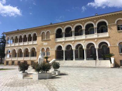
9) Archbishop's Palace
The Archbishop's Palace was built between 1956 and 1960 and stands next to the Old Archbishop's Palace, which was built in the 17th century. The new Archbishop's Palace features a neo-Byzantine style and was designed by George Nomikos.
The new Archbishop's Palace houses the Byzantine Museum and the Library of the Archdiocese. The Byzantine Museum has an impressive collection of Byzantine art. The museum displays over 200 icons that date from the 9th century to the 19th century. The icon exhibit features a large collection of icons from the 12th century.
The Byzantine Museum has sixth-century mosaics that were taken from the Church of Panagia Kanakaria. The museum also features a gallery with artworks on Greek mythology, Christianity, and portraits. In addition, the museum features historical books and sacred vessels.
The Old Archbishop's Palace hosts the Folk Art Museum and the National Resistance Museum.
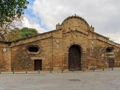
10) Famagusta Gate
The Famagusta Gate is part of Nicosia's medieval walls and is Nicosia's main city gate. The gate was originally called Giulio Gate to honor Giulio Savorgnano, who designed the Venetian walls. The gate was built in 1567.
The Famagusta Gate features a vaulted passage with a domed room. The room has natural light from a circular opening. The passage has rooms that originally housed guards.
The Ottomans restored the gate in 1821. During the Ottoman period, only Turks could remain on horseback while passing through the gate. Foreigners and Christians had to walk. The gate was again restored in 1980. During this restoration, the floor was covered with cement, and cobblestones were added to the area in front of the gate. In addition, air conditioning and lighting were added.
Today, the gate room hosts an art center that features exhibitions, movies, theater performances, and concerts.
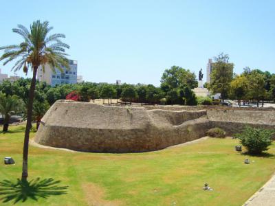
11) Podocataro Bastion and Medieval Venetian Walls (must see)
Nicosia's Medieval Venetian Walls are one of the city's most visited attractions. Nicosia's original walls were built during the Middle Ages. However, the Republic of Venice rebuilt the walls during the 16th century. Today, the walls are one of the Eastern Mediterranean's best-preserved city walls.
The first walls were built in the 14th century. When Cyprus became part of the Republic of Venice in 1489, the Venetians planned new fortifications, but their plans were delayed. Ottoman expansion inspired the Venetians to rebuild the city's walls in 1567. The Venetians also added an 80-meter-wide (262-feet) moat.
The walls were still under construction when the Ottomans invaded in 1570 and breached Podocattaro Bastion's walls. The Ottomans left thousands of soldiers in Nicosia and repaired the walls.
Nicosia's Venetian walls are circular and have eleven bastions and three gates. The bastions were named after members of the Italian aristocracy who donated funds to build the walls. Today, the Podocattaro Bastion is home to the Liberty Monument.
The walls feature innovative building techniques, such as improving the gate's protection and the wall's ability to withstand cannon fire.
Today, the walls are a much-visited tourist attraction. In addition, the dry moat is now used for sports fields, car parking, exhibitions, and a sculpture exhibition.
