Custom Walk in San Juan, Puerto Rico by kbugaj29_2273c4 created on 2026-07-26
Guide Location: Puerto Rico » San Juan
Guide Type: Custom Walk
# of Sights: 13
Tour Duration: 3 Hour(s)
Travel Distance: 4.4 Km or 2.7 Miles
Share Key: W6TFB
Guide Type: Custom Walk
# of Sights: 13
Tour Duration: 3 Hour(s)
Travel Distance: 4.4 Km or 2.7 Miles
Share Key: W6TFB
How It Works
Please retrieve this walk in the GPSmyCity app. Once done, the app will guide you from one tour stop to the next as if you had a personal tour guide. If you created the walk on this website or come to the page via a link, please follow the instructions below to retrieve the walk in the app.
Retrieve This Walk in App
Step 1. Download the app "GPSmyCity: Walks in 1K+ Cities" on Apple App Store or Google Play Store.



Step 2. In the GPSmyCity app, download(or launch) the guide "San Juan Map and Walking Tours".
Step 3. Tap the menu button located at upper right corner of the "Walks" screen and select "Retrieve custom walk". Enter the share key: W6TFB
1) Castillo San Cristóbal (Fort San Cristobal) (must see)
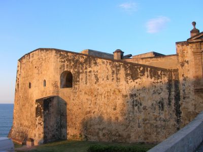
Standing guard at the eastern gate, north of Columbus Square, is an imposing 18th-century fortress, called San Cristóbal. Contrary to her sister, El Morro, which was designed to protect from attacks by sea, the San Cristóbal Fort guarded the city against the enemy approaching by land, for which purpose it created a crossfire with El Morro over the bay. The citadel construction began in 1634 and was meant to strengthen the Spanish position in the face of imminent English and Dutch invasion.
The fort was named San Cristóbal in celebration of the Spanish victories which enabled ejecting of the English and Dutch interlopers from the island of the same name in the Lesser Antilles, which was then part of the insular territorial glacis of Puerto Rico.
When finished in 1783, the Fort San Cristóbal covered nearly 27 acres of land and practically wrapped around the whole of San Juan, with the entry to the city sealed by the San Cristóbal's double gates. After almost 100 years of relative peace, about a third of the fortification was demolished, in 1897, to help ease the flow of traffic in and out of the walled city.
The Fort San Cristóbal is now a listed National Historic Site. It is particularly worth visiting as the largest fortification ever built by the Spanish in the New World, where the first shots of the Spanish-American War were fired. If you're a keen photographer, San Cristobal is a goldmine of panoramic views of the coast, from Old San Juan to Condado and beyond.
Tip:
Guided tours by local rangers visit the extensive tunnel system connecting various sections of the fort. There is an exhibition of military clothing. Be sure to visit the overlook for the Devil's Sentry Box ("Garita del Diablo"), from which, according to legends, soldiers mysteriously disappeared. Tickets to San Cristobal or El Morro can be used to enter either of the forts.
The fort was named San Cristóbal in celebration of the Spanish victories which enabled ejecting of the English and Dutch interlopers from the island of the same name in the Lesser Antilles, which was then part of the insular territorial glacis of Puerto Rico.
When finished in 1783, the Fort San Cristóbal covered nearly 27 acres of land and practically wrapped around the whole of San Juan, with the entry to the city sealed by the San Cristóbal's double gates. After almost 100 years of relative peace, about a third of the fortification was demolished, in 1897, to help ease the flow of traffic in and out of the walled city.
The Fort San Cristóbal is now a listed National Historic Site. It is particularly worth visiting as the largest fortification ever built by the Spanish in the New World, where the first shots of the Spanish-American War were fired. If you're a keen photographer, San Cristobal is a goldmine of panoramic views of the coast, from Old San Juan to Condado and beyond.
Tip:
Guided tours by local rangers visit the extensive tunnel system connecting various sections of the fort. There is an exhibition of military clothing. Be sure to visit the overlook for the Devil's Sentry Box ("Garita del Diablo"), from which, according to legends, soldiers mysteriously disappeared. Tickets to San Cristobal or El Morro can be used to enter either of the forts.
Sight description based on Wikipedia.
2) Plaza de Armas (Arms Square) (must see)
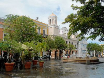
Arms Square is the de-facto central square of San Juan. Over the years, it has changed several names relative to the functions it served. Initially, in 1521, it was called Vegetables Square. Then, during the 17th-19th centuries, it was known as Arms Square, for being the grounds for military drills. After that, in the early 20th century, it turned back to being called Vegetables Square once again, serving as a marketplace, before it finally re-assumed the Arms Square title.
The plaza is modeled on the classic squares of Madrid and Mexico City. Although it factually existed for centuries, it was not until 1840 that the city council approved its proper development, which started in 1851. It was at that time that the four bronze statues, oil-coated to simulate marble, representing Commerce, Industry, Science, and the Arts, arrived here (there were a total of eight statues to be installed, but the other four were lost). In 1872, the original statues were replaced with the new marble ones, representing the Four Seasons, put in the four corners of the square.
In 1955, two circular fountains and two lampposts in the center were added. The four statues were then configured in a circular fountain outside the Palacio de la Real Intendencia, which is the seat of the Department of State of Puerto Rico, on the western side of the square.
A highlight of the northern side is the Casa Alcaldía – home of the San Juan City Hall. Built in 1789, this Spanish colonial-style edifice with twin turrets resembles its sister building in Madrid. The tinkling of the fountain, the comfortable seating in the shade of the trees, and the presence of several old-style coffee booths selling snacks have long attracted tourists as a good spot for a sightseeing break when you can stretch out your feet and soak up some of the everyday comings and goings.
The laid-back atmosphere of the place also made it a popular gathering venue with locals, offering a chance to buy kids some traditional treats (like sesame-seed lollipops or coconut candies), watch shows, play dominoes, or chit-chat with friends.
The plaza is modeled on the classic squares of Madrid and Mexico City. Although it factually existed for centuries, it was not until 1840 that the city council approved its proper development, which started in 1851. It was at that time that the four bronze statues, oil-coated to simulate marble, representing Commerce, Industry, Science, and the Arts, arrived here (there were a total of eight statues to be installed, but the other four were lost). In 1872, the original statues were replaced with the new marble ones, representing the Four Seasons, put in the four corners of the square.
In 1955, two circular fountains and two lampposts in the center were added. The four statues were then configured in a circular fountain outside the Palacio de la Real Intendencia, which is the seat of the Department of State of Puerto Rico, on the western side of the square.
A highlight of the northern side is the Casa Alcaldía – home of the San Juan City Hall. Built in 1789, this Spanish colonial-style edifice with twin turrets resembles its sister building in Madrid. The tinkling of the fountain, the comfortable seating in the shade of the trees, and the presence of several old-style coffee booths selling snacks have long attracted tourists as a good spot for a sightseeing break when you can stretch out your feet and soak up some of the everyday comings and goings.
The laid-back atmosphere of the place also made it a popular gathering venue with locals, offering a chance to buy kids some traditional treats (like sesame-seed lollipops or coconut candies), watch shows, play dominoes, or chit-chat with friends.
3) Parque de las Palomas (Pigeon Park)
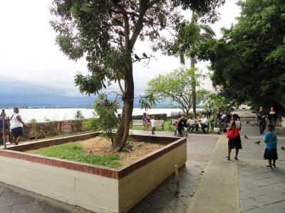
Pigeon Park offers a unique experience for visitors. A small kiosk sells pigeon feed, but these friendly birds are so accustomed to human presence that they may land on you even if you don't have food. The park is adorned with bird toys and decorations, lovingly put up and maintained by the adjacent Café del Niño. Adding to its charm, the park boasts a gorgeous overlook of San Juan and the San Juan Bay.
In the 18th century, the heavily fortified city of San Juan erected a wall for cannon placement, overlooking the southeastern coast of Puerto Rico. When the cannons were eventually removed or ceased to be used, pigeons found a new home in the sockets left behind. Over the years, families have delighted in bringing their children to feed the bustling pigeon population that settled in these historic remnants
In the 18th century, the heavily fortified city of San Juan erected a wall for cannon placement, overlooking the southeastern coast of Puerto Rico. When the cannons were eventually removed or ceased to be used, pigeons found a new home in the sockets left behind. Over the years, families have delighted in bringing their children to feed the bustling pigeon population that settled in these historic remnants
4) Capilla del Cristo (Chapel of Christ) (must see)
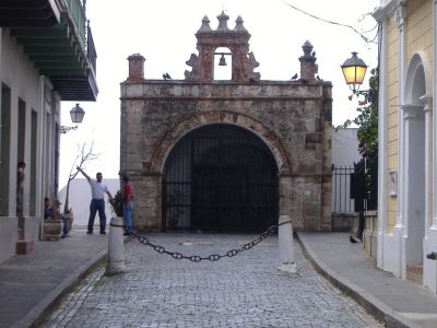
Capilla del Cristo (Chapel of Christ), is a small chapel located in the Old San Juan Historic District of Puerto Rico. Built in the 18th century, the structure has become a cultural icon of Puerto Rico and was saved from demolition in the 20th century. Most of the articles located at its altar are from 1753.
The chapel with its belfry is located in the Old San Juan Historic District in the western section of San Juan Islet, at the end of Cristo Street, now a pedestrian walkway. It sits on top of the old city walk. The chapel is a major tourist attraction in San Juan. Inside the chapel there is a famous painting called El Milagro ("The Miracle").
According to the legend, during a horse race that was taking place on the street where the chapel is located, a young rider and his horse took a bad fall and the rider went over the city wall but was miraculously saved. In a famous book about Puerto Rican legends, it says that the horse was killed but the rider lived. Afterwards, permission was granted to build the Catholic chapel and many festivals have been held, over the years, at the location to celebrate the miracle.
The chapel is open to publish on Saturday and Sunday from 12:00 to 18:00.
The chapel with its belfry is located in the Old San Juan Historic District in the western section of San Juan Islet, at the end of Cristo Street, now a pedestrian walkway. It sits on top of the old city walk. The chapel is a major tourist attraction in San Juan. Inside the chapel there is a famous painting called El Milagro ("The Miracle").
According to the legend, during a horse race that was taking place on the street where the chapel is located, a young rider and his horse took a bad fall and the rider went over the city wall but was miraculously saved. In a famous book about Puerto Rican legends, it says that the horse was killed but the rider lived. Afterwards, permission was granted to build the Catholic chapel and many festivals have been held, over the years, at the location to celebrate the miracle.
The chapel is open to publish on Saturday and Sunday from 12:00 to 18:00.
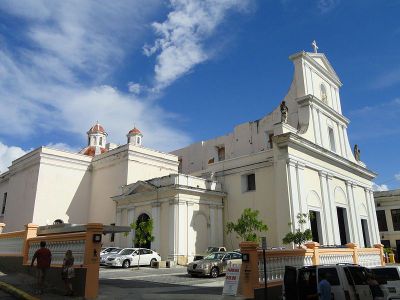
5) Cathedral of San Juan Bautista (must see)
The Cathedral of San Juan Bautista is the Roman Catholic temple and the seat of the Archdiocese of San Juan de Puerto Rico. This is one of the oldest buildings in San Juan and the second-oldest operational church in the Americas. Traditionally, travelers entering San Juan Gate would make this cathedral their first stop in the city to thank God for their safe journey.
It sits on the site of a grammar school, established in 1513 by Bishop Alonso Manso. This was the first school in Puerto Rico (and the oldest school in the United States after Puerto Rico became a US territory). Here, the Latin language, literature, history, science, art, philosophy, and theology were taught free of charge.
The very first, wooden, church on this spot was built in 1521. It was destroyed by a hurricane, and the current temple of stone was built in its place, in 1540. The church was remodeled several times over the course of centuries, most recently in 1917.
The cathedral contains the tomb of the Spanish explorer Juan Ponce de León. It also houses a shrine dedicated to the Blessed Carlos Manuel Rodríguez Santiago, the first Puerto Rican and the first Caribbean-born layperson (much as the first layperson in the history of the United States) to be beatified.
The Cathedral of San Juan Bautista is also unique as a rare example of medieval Spanish architecture in the New World.
It sits on the site of a grammar school, established in 1513 by Bishop Alonso Manso. This was the first school in Puerto Rico (and the oldest school in the United States after Puerto Rico became a US territory). Here, the Latin language, literature, history, science, art, philosophy, and theology were taught free of charge.
The very first, wooden, church on this spot was built in 1521. It was destroyed by a hurricane, and the current temple of stone was built in its place, in 1540. The church was remodeled several times over the course of centuries, most recently in 1917.
The cathedral contains the tomb of the Spanish explorer Juan Ponce de León. It also houses a shrine dedicated to the Blessed Carlos Manuel Rodríguez Santiago, the first Puerto Rican and the first Caribbean-born layperson (much as the first layperson in the history of the United States) to be beatified.
The Cathedral of San Juan Bautista is also unique as a rare example of medieval Spanish architecture in the New World.
Sight description based on Wikipedia.
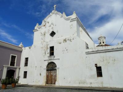
6) Iglesia de San José (San José Church)
San Jose Church (Iglesia de San Jose), located in Old San Juan, is one of the first significant works of architecture on the island. The church was first opened in 1532 and is one of the earliest surviving examples of 16th-century Spanish Gothic architecture in the Western hemisphere.
Juan Ponce de León, the first governor of Puerto Rico, was buried in the crypt of the church from 1559 to 1836, when his remains were exhumed and later transferred to the Cathedral of San Juan Bautista. However, his coat of arms is still located near the main altar. His grandson, Juan Ponce de Leon II is buried in the crypt beneath the Sanctuary's floor. Puerto Rican painter José Campeche is also buried in the church.
In 2002, a restoration project on the structure began and several painted murals were discovered including a mid-19th century depiction of the Battle of Lepanto. In 2004, the church was listed on the 2004 World Monuments Watch by the World Monuments Fund, which helped the conservation effort.
The Church of Saint Joseph is closed to visitors due to the restoration work that has been going on. It is expected to re-open in 2020.
Juan Ponce de León, the first governor of Puerto Rico, was buried in the crypt of the church from 1559 to 1836, when his remains were exhumed and later transferred to the Cathedral of San Juan Bautista. However, his coat of arms is still located near the main altar. His grandson, Juan Ponce de Leon II is buried in the crypt beneath the Sanctuary's floor. Puerto Rican painter José Campeche is also buried in the church.
In 2002, a restoration project on the structure began and several painted murals were discovered including a mid-19th century depiction of the Battle of Lepanto. In 2004, the church was listed on the 2004 World Monuments Watch by the World Monuments Fund, which helped the conservation effort.
The Church of Saint Joseph is closed to visitors due to the restoration work that has been going on. It is expected to re-open in 2020.
Sight description based on Wikipedia.
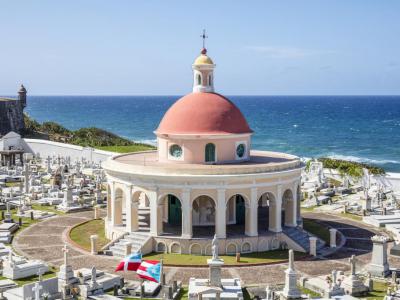
7) Santa María Magdalena de Pazzis Cemetery (must see)
Santa María Magdalena de Pazzis Cemetery is a colonial-era cemetery located in Old San Juan, Puerto Rico. It is the final resting place of many of Puerto Rico's most prominent natives and residents. Construction began in 1863 under the auspices of Ignacio Mascaro. The cemetery is located outside the walls of Fort San Felipe del Morro fortress, one of the island's most famous landmarks.
It was named in honor of Saint Maria Magdalena de Pazzi. The location of the cemetery is central to the Puerto Rican belief in the separation of death and life. The colonial Spanish government at the time the construction of the cemetery commenced, viewed death with fear because it was a mystery. Therefore, they decided to build the cemetery to overlook the Atlantic Ocean to symbolize the spirit's journey to cross over to the afterlife.
It was named in honor of Saint Maria Magdalena de Pazzi. The location of the cemetery is central to the Puerto Rican belief in the separation of death and life. The colonial Spanish government at the time the construction of the cemetery commenced, viewed death with fear because it was a mystery. Therefore, they decided to build the cemetery to overlook the Atlantic Ocean to symbolize the spirit's journey to cross over to the afterlife.
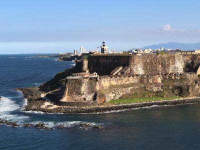
8) El Castillo San Felipe del Morro (Fort El Morro) (must see)
The Fort San Felipe del Morro, or simply El Morro, is a 16th-century citadel on the northwestern tip of the San Juan islet, named in honor of King Philip II of Spain. It was the second military installation, after La Fortaleza, built in what is now known as the Old Town.
The construction began in 1539, authorized by King Charles V, and was finished in 1790. During that period, El Morro had been transformed from a promontory mounted with a cannon to a six-level fortress designed to guard the entrance to the bay of San Juan from seaborne invaders. Many more structures were added to the complex over the next 400 years; the outer walls, built initially 6 feet (1.8 m) thick, were augmented to 18 feet (5.5 m) by the end of the 18th century.
Thanks to El Morro, the Spanish were able to defend Puerto Rico from invasions by the British and the Dutch, as well as pirates. In 1898, following the Spanish-American War, the island changed hands from Spain to the United States. El Morro was actively used as a military installation during the First and Second World Wars.
In 1961, the US Army retired El Morro, passing it on to the National Park Service to use it as a museum. In 1983, El Morro and the walled city of Old San Juan were declared UNESCO World Heritage Sites.
Tips:
A ticket to El Morro allows entry to the Castillo San Cristóbal (and vice versa) for a single fee.
The construction began in 1539, authorized by King Charles V, and was finished in 1790. During that period, El Morro had been transformed from a promontory mounted with a cannon to a six-level fortress designed to guard the entrance to the bay of San Juan from seaborne invaders. Many more structures were added to the complex over the next 400 years; the outer walls, built initially 6 feet (1.8 m) thick, were augmented to 18 feet (5.5 m) by the end of the 18th century.
Thanks to El Morro, the Spanish were able to defend Puerto Rico from invasions by the British and the Dutch, as well as pirates. In 1898, following the Spanish-American War, the island changed hands from Spain to the United States. El Morro was actively used as a military installation during the First and Second World Wars.
In 1961, the US Army retired El Morro, passing it on to the National Park Service to use it as a museum. In 1983, El Morro and the walled city of Old San Juan were declared UNESCO World Heritage Sites.
Tips:
A ticket to El Morro allows entry to the Castillo San Cristóbal (and vice versa) for a single fee.
Sight description based on Wikipedia.
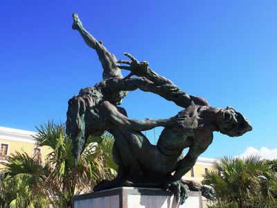
9) La Ballajá Sculpture
Near Instituto de Cultura Puertorriquena, Museo de las Américas and historic Cuartel de Ballajá, you will find the fascinating sculpture, La Ballajá. It consists of three figures, beautifully united in the overall composition.
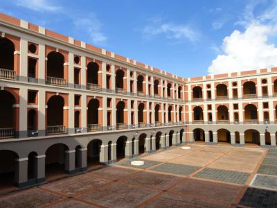
10) Cuartel de Ballajá (Ballaja Barracks)
Ballaja Barracks (or Cuartel de Ballajá in Spanish) is a military barracks located in San Juan. It was built from 1854 to 1864 for the Spanish troops established on the island and their families.
The three-story structure was completed in 1864, occupying an area of 7,700 square meters (83,000 sq ft). It could accommodate over 1,000 citizens, originally Spanish soldiers and their families. Its vast interior patio is one of the best examples of 19th-century Spanish architecture.
The barracks were heavily used during the Spanish–American War near the end of the 19th century. On May 12, 1898, during the American bombing of San Juan, the fleet led by Admiral William T. Sampson damaged the northeast side of the barracks. After the war ended, and with the change of sovereignty, the barracks became the quarters for the United States Army until 1939.
Today, the Ballaja Barracks houses several educational and cultural organizations including the Latin America Museum on its second floor. The museum offers three permanent collections: African Heritage, the Indian in America, and Popular Arts in America.
The three-story structure was completed in 1864, occupying an area of 7,700 square meters (83,000 sq ft). It could accommodate over 1,000 citizens, originally Spanish soldiers and their families. Its vast interior patio is one of the best examples of 19th-century Spanish architecture.
The barracks were heavily used during the Spanish–American War near the end of the 19th century. On May 12, 1898, during the American bombing of San Juan, the fleet led by Admiral William T. Sampson damaged the northeast side of the barracks. After the war ended, and with the change of sovereignty, the barracks became the quarters for the United States Army until 1939.
Today, the Ballaja Barracks houses several educational and cultural organizations including the Latin America Museum on its second floor. The museum offers three permanent collections: African Heritage, the Indian in America, and Popular Arts in America.
Sight description based on Wikipedia.
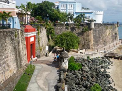
11) San Juan Gate and City Wall (must see)
Built in the late 1700s, the San Juan Gate is a giant (40 feet high) structure, the last remaining of the original five gates carved into the three-mile wall that once surrounded the city. Today, the wall wraps around Old San Juan, from the cruise ship piers on San Juan Harbor to the capitol on the Atlantic.
Originally, each gate had a designated function. The red gate of San Juan played a symbolic role, serving as the main entrance to the city, and was named in honor of Saint John the Baptist. The first thing you notice approaching it is the inscription of The Sanctus ("Holy") hymn from the Catholic liturgy.
The city wall is the most enduring symbol of Puerto Rico and was built by the Spanish between 1539 and 1782. Made of sandstone, rubble, and mortar blocks – 20 feet thick, the wall measures 45 feet wide and 40 feet high in some parts and was meant to protect San Juan from invaders, notably the English, the Dutch, and the Americans. Its iconic sentry boxes now symbolize the island's Spanish heritage and resilience in an ever-changing world.
Nearly impenetrable to foreign attack, the city wall proved defenseless, nonetheless, against modern automobile traffic, pollution, and misguided attempts to preserve it that have seriously endangered the wall, leaving it crumbling in some places.
Currently a National Historic Site, the city wall is maintained by the National Park Service which attempts to recreate the magic mixture of sand, water, and limestone that was once used to stucco the wall. Along with the adjoining fortresses of El Morro and San Cristóbal, the city wall attracts 1.2 million visitors each year.
Tip:
As you walk through the gate, just pause for a second and notice how thick the walls really are. Also, check out the street vendors outside, on the corner, offering refreshments including Puerto Ricans' favorite, piragua.
Originally, each gate had a designated function. The red gate of San Juan played a symbolic role, serving as the main entrance to the city, and was named in honor of Saint John the Baptist. The first thing you notice approaching it is the inscription of The Sanctus ("Holy") hymn from the Catholic liturgy.
The city wall is the most enduring symbol of Puerto Rico and was built by the Spanish between 1539 and 1782. Made of sandstone, rubble, and mortar blocks – 20 feet thick, the wall measures 45 feet wide and 40 feet high in some parts and was meant to protect San Juan from invaders, notably the English, the Dutch, and the Americans. Its iconic sentry boxes now symbolize the island's Spanish heritage and resilience in an ever-changing world.
Nearly impenetrable to foreign attack, the city wall proved defenseless, nonetheless, against modern automobile traffic, pollution, and misguided attempts to preserve it that have seriously endangered the wall, leaving it crumbling in some places.
Currently a National Historic Site, the city wall is maintained by the National Park Service which attempts to recreate the magic mixture of sand, water, and limestone that was once used to stucco the wall. Along with the adjoining fortresses of El Morro and San Cristóbal, the city wall attracts 1.2 million visitors each year.
Tip:
As you walk through the gate, just pause for a second and notice how thick the walls really are. Also, check out the street vendors outside, on the corner, offering refreshments including Puerto Ricans' favorite, piragua.
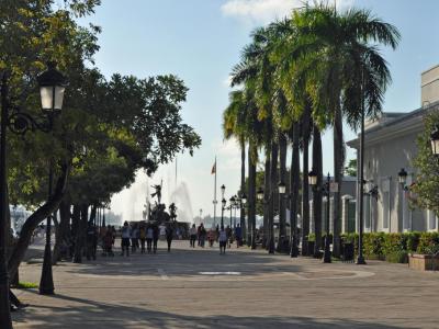
12) Paseo de la Princesa (Princess Promenade) (must see)
No trip to San Juan is complete without a stroll along the beautiful Princess Promenade, a carefully restored historic landmark, one of the most visited in the capital. Built in 1853, this esplanade skirts the curved city walls on the southern side of Old San Juan and is quite picture-perfect, with the San Juan Bay on the one side and the impressive fortification walls on the other.
The Promenade is equally suited for both walking and people-watching. It is also a great place to visit for families with children – easily accessible and traffic-free. The abundance of trees here provides plenty of shade, and there are lots of artisan stalls and street vendors selling local food. The area also often hosts festivals and fairs on weekends.
From here, you can make a slight detour to the narrow path, known as Paseo El Morro, leading to the historic El Morro Fort and the nearby San Juan Gate, which is the only city gate remaining from the colonial period.
Princess Promenade gets its name from an old 1837 building, located here, known as La Princesa. Originally, this building served as a municipal prison, although presently it houses the headquarters of the Puerto Rico Tourism Company and an art gallery.
The Promenade is equally suited for both walking and people-watching. It is also a great place to visit for families with children – easily accessible and traffic-free. The abundance of trees here provides plenty of shade, and there are lots of artisan stalls and street vendors selling local food. The area also often hosts festivals and fairs on weekends.
From here, you can make a slight detour to the narrow path, known as Paseo El Morro, leading to the historic El Morro Fort and the nearby San Juan Gate, which is the only city gate remaining from the colonial period.
Princess Promenade gets its name from an old 1837 building, located here, known as La Princesa. Originally, this building served as a municipal prison, although presently it houses the headquarters of the Puerto Rico Tourism Company and an art gallery.
13) Calle de la Fortaleza (Fortaleza Street) (must see)
Proudly presiding over the bay of San Juan is the imposing La Fortaleza (Fortress), formally known as the Palace of Santa Catalina, the official residence of the Governor of Puerto Rico. The narrow road leading to the building, called Fortaleza Street, is the main artery of San Juan's historic quarter, cutting through most of it, and is also the oldest street in the area. It starts from Columbus Square and for the whole of its duration is lined with governmental buildings, hotels, perfumeries, craft shops, jewelry stores, and restaurants, gradually transforming into Avenue Juan Ponce de León in the east.
Just like many other colorful cobblestone streets in Old San Juan, each one more photogenic than the other, this thoroughfare is an important tourist attraction, in large part due to its historical and cultural significance. Visiting Fortaleza Street should be an integral part of every Old San Juan itinerary.
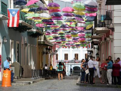
While the walled-in Old City has no shortage of vibrant photo spots, Fortaleza Street stands out above the rest due to the display of umbrellas – at the end of the street, near La Fortaleza itself – creating an overhead canopy that makes it particularly recognizable. These umbrellas tend to change colors during the year, from rainbow to all pink. Before the umbrellas, La Fortaleza Street was adorned with colorful kites.
Just like many other colorful cobblestone streets in Old San Juan, each one more photogenic than the other, this thoroughfare is an important tourist attraction, in large part due to its historical and cultural significance. Visiting Fortaleza Street should be an integral part of every Old San Juan itinerary.
While the walled-in Old City has no shortage of vibrant photo spots, Fortaleza Street stands out above the rest due to the display of umbrellas – at the end of the street, near La Fortaleza itself – creating an overhead canopy that makes it particularly recognizable. These umbrellas tend to change colors during the year, from rainbow to all pink. Before the umbrellas, La Fortaleza Street was adorned with colorful kites.
Sight description based on Wikipedia.
