Chester's City Walls, Chester

Chester's City Walls (Self Guided), Chester

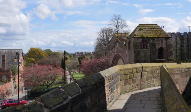
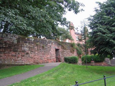
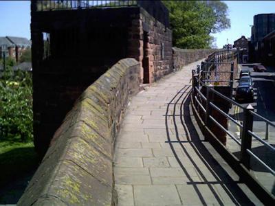
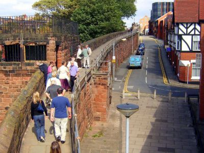
Chester City Walls are the oldest, longest and most complete (missing only just about 100 meters) historic defensive structure in Britain. Walking the full circuit of this ancient fortification provides wondrous views, wherever you choose to go, down into the city, and offers a fantastic insight into Chester's rich history.

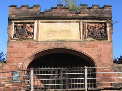
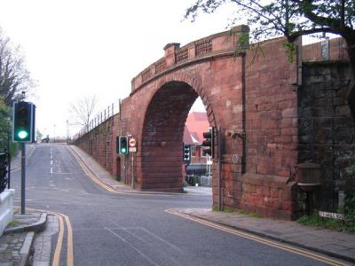
First built by the Romans almost 2,000 years ago, the Walls were extended and developed during the Saxon period (10th century), and then further modified in the 12th century by the Normans. Eventually, through various additions and alterations, they had formed a complete circuit around Chester, making it one of the most protected and strategically important city in the country, back in the middle ages.

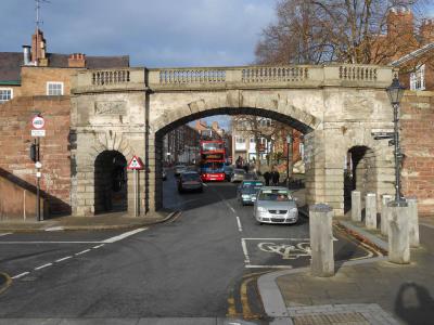
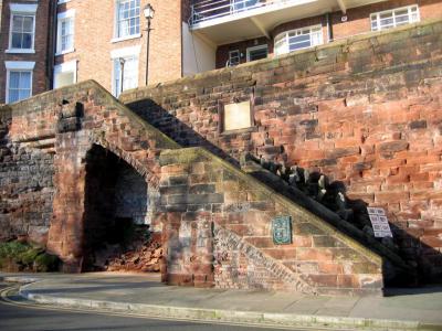
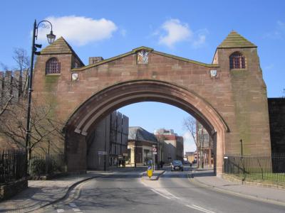
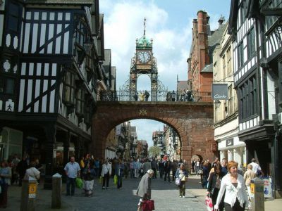
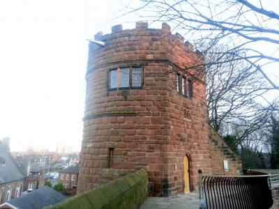
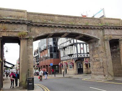
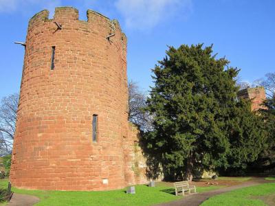
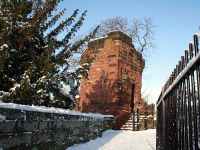
One of the reasons the Walls have survived until present is that since the 18th century they had ceased being used for defense and been adapted to become a fashionable walk and public amenity. The main access onto the Walls is via four major gateways: Northgate, Eastgate, Watergate and Bridgegate. There are also many steps along the Walls, such as Recorder's Steps, some having accessible ramps; plus a number of towers, including Water Tower, Phoenix Tower, and Bonewaldesthorne's Tower.

If you wish to travel back in time down the ancient Walls of Chester and learn about its eventful past, take this self-guided walking tour.
How it works: Download the app "GPSmyCity: Walks in 1K+ Cities" from Apple App Store or Google Play Store to your mobile phone or tablet. The app turns your mobile device into a personal tour guide and its built-in GPS navigation functions guide you from one tour stop to next. The app works offline, so no data plan is needed when traveling abroad.

Download The GPSmyCity App

Chester's City Walls Map

Guide Name: Chester's City Walls
Guide Location: England » Chester (See other walking tours in Chester)
Guide Type: Self-guided Walking Tour (Sightseeing)
# of Attractions: 13
Tour Duration: 2 Hour(s)
Travel Distance: 2.3 Km or 1.4 Miles
Author: rose
Sight(s) Featured in This Guide:
  • Bridgegate
  • Recorder's Steps
  • Newgate
  • Eastgate and Eastgate Clock
  • Kaleyard Gate
  • Phoenix Tower
  • Northgate
  • Morgan's Mount
  • St. Martin's Gate
  • Pemberton's Parlour
  • Water Tower
  • Bonewaldesthorne's Tower
  • Watergate
1
Bridgegate

1) Bridgegate

The Bridgegate is in Chester. The Roman city walls were extended to the south in the 12th century with a wall parallel to the north bank of the River Dee. This section of the wall incorporated the original Bridgegate which must have been built by the 1120s, as the office of sergeant of the gate was recorded in that decade. The gate guarded the southern entrance to the town; the road from North Wales ran through the gateway directly after crossing the Old Dee Bridge. It is possible that the gateway was rebuilt at the time the bridge was rebuilt in the later part of the 14th century. Between 1521 and 1624 the bridge tolls were controlled by the Talbot family, the Earls of Shrewsbury, whose town house, now the Bear and Billet, was nearby.

At the end of the 15th century the bridge consisted of a Gothic arch with a tower on each side. In 1600–01 a square tower was added which contained machinery for lifting river water into the town. This was known as John Tyrer's Water Tower, after its builder, but the tower was destroyed in the siege of Chester in 1644–65. The present bridge was built in 1781 for Chester City Corporation, the architect being Joseph Turner.
Sight description based on Wikipedia.
2
Recorder's Steps

2) Recorder's Steps

The Recorder's Steps consist of two flights of stone steps leading down from the walkway at the top of the City Walls in Chester to a riverside area known as the Groves.

The steps are in two flights, of 12 and 15 steps respectively, and were constructed between 1820 and 1822 for Chester Corporation. The lower flight is separated from the wall by a strip of
Gothic stonework.

On the wall nearby is a stone plaque, set probably in 1881, containing erroneous information, being inscribed "RECORDER'S STEPS Erected by the Corporation of this City A.D. 1700 for the Convenience of ROGER COMBERBACH, Recorder", suggesting that the steps were to allow access to his house. This may be inaccurate, for in 1720, the year after the Recorder's death, the Assembly ordered the city's mason to make a new flight of stairs between the Bridge and Dee Lane.

Very soon afterwards, on 21st May 1721, one Kenneth Edwards, a tanner, fell down the 'new stairs' and died. In 1730, Comberbach's son, also Roger, built himself a new home, Dee House, on the site of Chester's Roman amphitheatre.

The Steps are currently recorded on the National Heritage List for England.
3
Newgate

3) Newgate

Newgate is an arch bridge carrying the walkway of the City Walls over Pepper Street in Chester. The predecessor of the grander entrance, Peppergate or Wolfgate, can be seen nearby; it was once also known as the "Newegatt" (Newgate), after a rebuilding in 1553. There is an old local saying connected with this gate that goes: "When the daughter is stolen, shut the Peppergate", a proverbial equivalent of "Closing the stable door after the horse has bolted".

With the coming of a motor car, the old Peppergate/Wolfgate proved completely inadequate, so a new breach through the City Walls was needed. There was a considerable debate, at the time, regarding how it was to be executed. Finally, to relieve traffic congestion in the city, especially at Chester Cross, the new bridge was built in 1937–38.

Opened by the Mayor on October 3rd 1938, it featured a cheerful mock-Medieval style (or rather Gothic Revival), whose playfulness reminded a bit of the set of a Hollywood production of Robin Hood. Despite appearances, the Newgate is actually built of reinforced concrete and faced with red Runcorn sandstone. The architect, Sir Walter Tapper, died before its completion, so the work – which took a mere 20 months – had to be completed by his son, Michael Tapper.

On each side of the bridge is a tower containing mock loops (unglazed slit windows) and surmounted by hipped roofs. Flights of steps on each side lead up to the towers and to the walkway across the top of the bridge. The structure is decorated with carved shields and Tudor roses. The historian Simon Ward expressed the opinion that "its design conformed to the generally medieval feel of the walls".

Quite fittingly, the bridge is now part of the National Heritage List for England.
Sight description based on Wikipedia.
4
Eastgate and Eastgate Clock

4) Eastgate and Eastgate Clock (must see)

Eastgate and Eastgate Clock stand on the site of the original entrance gate to the Deva Victrix fortress which was a legionary fortress and town in the Roman province of Britannia. The fortress was built around the AD 70 as the Roman army advanced north against the Brigantes, and rebuilt completely over the next few decades.

The fortress was rebuilt in the early 3rd century. The Roman army probably remained at the fortress until the late 4th or early 5th century, then it fell into disuse. A civilian settlement, or canabae, grew around the fortress and it remained after the Romans departed, eventually becoming the present-day city of Chester.

The original gate is said to date to about AD 74. It was replaced in the 2nd century, and then again in the 14th century. The current Eastgate dates to 1768.

Eastgate Clock was added in 1899 in celebration of Queen Victoria's diamond jubilee. It was designed by architect John Douglas. It has a face on all four sides with the year 1897 and initials VR appearing above and below each clock face. A copper ogee cupola is mounted over the clock with a large weather vane.

It is said that Eastgate Clock is the second most photographed clock in England after Big Ben in London. Eastgate and Eastgate Clock are among the most well-known landmarks in the city. They were designated as a Grade I listed building in 1955.
5
Kaleyard Gate

5) Kaleyard Gate

Kaleyard Gate is a postern breach in Chester City Walls, a smaller affair compared to other Chester's gates. It consists of a simple narrow opening in the sandstone wall, equipped with a stout oak door.

Back in the 13th century, the monks of St Werburgh's Abbey developed a vegetable garden (known as kaleyard) outside the City Walls. They wanted an easier access to it than the devious walk through Eastgate, so the Abbot petitioned Edward I in 1275 to allow them to make a shortcut through the wall directly into the garden. This was allowed under certain conditions, one of which was that the gate must be locked at nightfall.

In those troubled times, when the risk of armed attack was a deadly reality, all the city gates were closed at curfew – 8.00pm – and at times of danger. After Henry VIII's dissolution of monasteries, the duty of securing Kaleyard Gate fell to the Dean & Chapter of the newly-created Cathedral.

The curfew is still rung from the Cathedral's belfry at 8.45 each evening and the Kaleyard Gate is locked at 9 o'clock sharp, to be re-opened at sunrise. It is the only remaining city gate at which this ancient custom, originated in the Norman law of couvre feu ('cover fire' – to ensure the safety of the largely timber-built town, all fires had to be extinguished – which gave rise to the modern curfew), is still observed.

A few years ago, out of concern that the Cathedral staff may be assaulted while carrying out their duty, the evening locking of the Gate was discontinued. However, in June 2012, the ancient practice was resumed and is now carried out by a Cathedral Constable, an office established in December 2011 to look after the security of the Cathedral and its Estate.
Sight description based on Wikipedia.
6
Phoenix Tower

6) Phoenix Tower

Phoenix Tower stands at the northeast corner of the city walls in Chester. The tower is recorded in the National Heritage List for England as a designated Grade I listed building. It has also been known as Newton Tower and King Charles' Tower.

The structure probably originated in the 13th century. During the later part of the 16th century the tower was leased to two city guilds, the Painters and Stationers, and the Barbers and Chandlers, who sublet it to other guilds. By 1612 the fabric of the tower was in a poor condition, and the lead had been lost from its roof. It was restored by the two guilds, and above the door they placed a plaque containing the date 1613 and a carving of a phoenix, the emblem of the Painters.

In the Civil War, during the Siege of Chester in 1645, the tower had a gun in each storey, and it was damaged in the conflict. A plaque on the tower states that King Charles I stood on the tower on 24 September 1645 as he watched his soldiers being defeated at the Battle of Rowton Heath. The historian Simon Ward has expressed doubts about this and has suggested that the king may have stood instead on a tower of Chester Cathedral, which he considers is confirmed by evidence that a captain standing beside him was killed by a stray shot.

The guilds resumed possession of the tower in 1658, and repaired it. They ceased possession by about 1773, after which the city carried out repairs. However, by 1838, the tower was described as being in a dilapidated condition. By this time, the city was promoting it as a tourist attraction because of its reputed connection with King Charles. In the late 1850s, the lower chamber was being used by a print-seller, and later in the century the tower was made a private museum.

The tower is constructed in red coursed sandstone, with a pyramidal slate roof. The tower is in four stages, the lower two of which are below the walkway on the wall. Each of the upper stages contains a chamber. At the level of the walkway, in the third stage, is a round-headed doorway. Above the doorway is a plaque dated 1613 containing the carved image of a phoenix.

An external stairway leads to the upper storey. Internally, the lower chamber is octagonal in plan, with a diameter of about 30 feet (9 m), and it contains five slit windows. Externally, between the upper two stages, is a string course. In the upper stage is a doorway and four three-light leaded casement windows. The top of the tower has a battlemented parapet, lead hip roofs and an ornate weathervane.
Sight description based on Wikipedia.
7
Northgate

7) Northgate

The Northgate is in Chester where it carries the city walls footpath over Northgate Street. It is recorded in the National Heritage List for England as a designated Grade I listed building.

The present Northgate stands on the site of the original northern Roman entrance to Chester. During the medieval period, it was unimportant and it was used only for local access. At that time it consisted of a simple rectangular tower with a narrow gateway. It later was the site of the local goal. The present Northgate was built in 1810 to replace a medieval gatehouse and was designed by Thomas Harrison for Chester City Council.

It is built in pale red sandstone ashlar and consists of a segmental arch with a coffered soffit which spans the carriageway. On each side of the arch is a rectangular portal for the pavement. On both sides of the portals are attached unfluted monolithic Doric half-columns at each corner. Across the top of the structure is a dentilled cornice which carries a panelled parapet. In constructing Northgate, Harrison used "as few and as huge stones as possible".
Sight description based on Wikipedia.
8
Morgan's Mount

8) Morgan's Mount

Morgan's Mount is a structure extending from the north site of the city walls of Chester. It is recorded in the National Heritage List for England as a designated Grade I listed building.

It was constructed in 1645 during the siege of Chester in the Civil War as an observation platform and gun emplacement. After the Battle of Rowton Heath in September of that year, a gun on the Mount was destroyed by Parliamentary forces. It was originally named the Raised Square Platform, and is said to have been named later after the Royalist Captain William Morgan, or his son, Edward.

The Mount is constructed in red sandstone coursed rubble, and is rectangular in shape. It contains a chamber at the level of the walkway, with barred openings to the west and the north. Two flights of five steps lead up to the roof, which has a stone parapet surmounted by an iron railing. At the northeast corner of the roof is an L-shaped stone bench.
Sight description based on Wikipedia.
9
St. Martin's Gate

9) St. Martin's Gate

St Martin’s Gate is the most recent addition to Chester City Walls. It was opened in 1966, as part of the Inner Ring Road scheme, designed to ease the city's traffic problems. The Gate's name derived from a small ancient church which once stood nearby for the best part of a millennium. It was closed in 1963 to be demolished around 1969 so as to give space for the road, a nearby part of which is now known as "St Martin's Way".

Ahead of the building work, a team of archaeologists undertook a 16-week investigation of the site. During construction, remains of a Roman tower were found, along with some Roman and Saxon pottery, as well as the foundations of some previously-unknown agricultural buildings and features associated with a Roman cemetery. A large amount of green and yellow-glazed medieval roof tiles were also discovered, as well as later material dating from the 17th-19th centuries. These relics can now be seen through observation ports in the surrounding fencing, decorated with a series of fine murals by six local primary schools on the theme of “Routeways to Chester through Time”.

Typically for the 1960s, St. Martin's Gate was built in concrete. As you stand on top of it, the view from up here is the full extent of the North Wall, from Bonewaldesthorne's Tower to The Northgate. On occasions, you can see barges on the canal, bicycles on the towpath, trains on the railway and, inevitably, cars on the road below – all at the same time.

Today, St. Martin's is a very popular attraction and well worth your visit.
10
Pemberton's Parlour

10) Pemberton's Parlour

Pemberton's Parlour is a structure on the northern part of the Chester city walls, and it was formerly known as the Goblin Tower. It is recorded in the National Heritage List for England as a designated Grade I listed building.

The structure originated as a circular tower straddling the city walls. During the reign of Queen Anne it was rebuilt as a semicircular tower. It was reconstructed in 1894. It is now described as a gazebo, and is said to be named after John Pemburton, the mayor of Chester, who stood on it to supervise the work taking place on his nearby ropewalk.

The structure is built in red sandstone. On the south side, facing the walkway of the walls, is an arch leading to a semicircular chamber. Above this are three panels, the lateral ones containing the royal arms, and the arms of Chester in relief. Between these is another panel in yellow sandstone with an inscription relating to the repair of the walls in the 18th century. The parapet is crenellated and inscribed with "GOBLIN TOWER: REBUILT 1894".
Sight description based on Wikipedia.
11
Water Tower

11) Water Tower

The Water Tower (originally known as the New Tower) is a 14th-century tower in Chester, which is attached by a spur wall to Bonewaldesthorne's Tower on the city walls. The tower, together with its spur wall, is recorded in the National Heritage List for England as a designated Grade I listed building. The original name of the tower was New Tower but in the 17th century it became known as the Water Tower, although the City Assembly tried to insist on the usage of its correct name.

The tower was built between 1322 and 1325, at which time it stood in the River Dee. The architect was John (de) Helpston who had also designed castles for King Edward II in North Wales. Its prime purpose was to defend the port of Chester, and it was also used to monitor the movements of shipping and to ensure that the custom dues were paid

In 1639 the tower was renovated at the city's expense and during the following decade embrasures in the spur wall were made into gun ports. During the Civil War the tower was attacked and damaged. From 1671 it was leased as a storehouse but in 1728 it was described as "useless and neglected".

The Chester Mechanics' Institution was founded in 1835. The Institution wished to open a museum to show its artifacts and the city council leased the Water Tower and Bonewaldesthorne's Tower at a nominal rent for this purpose. The museum opened in 1838. The Institution closed in 1876 and the exhibits came into the possession of the city council. Although it was recognised that the tower was not suitable as a museum, there was at the time nowhere else to show all the exhibits. The tower closed as a museum in 1901–02 while the city walls were rebuilt, and re-opened in 1903, attracting 12,000 visitors that season.

The towers were closed to the public in 1916 and in the 1920s they were let for non-museum use. In 1954 they were bought by the Grosvenor Museum which reopened them to the public in 1962. The tower is now some 200 yards (183 m) inland from the river, and is probably the least-altered of Chester's medieval towers. The Water Tower and the adjacent Bonewaldesthorne's Tower have housed a museum of the history of medicine, 'Sick to Death', since August 2016.

The tower and spur wall are built in sandstone rubble. An archway in the city walls leads to 44 stone steps on the way down to the tower. The tower is circular at its base with a square turret above, in two stages containing octagonal chambers, one above the other. A pointed archway leads from the wall into the lower chamber. Five stone steps lead down from the archway through the wall to the lower chamber. Formerly in its walls were embrasures, but these have been blocked and are only visible from the exterior. A circular staircase of 23 steps leads to the upper chamber, which has four embrasures in its walls. Above this is a raised fighting platform overlooking the entrance to the tower. The top of the tower is crenellated.
Sight description based on Wikipedia.
12
Bonewaldesthorne's Tower

12) Bonewaldesthorne's Tower

Bonewaldesthorne's Tower is a medieval structure on the northwest corner of the city walls of Chester. It is attached by a spur wall to the Water Tower. It is recorded in the National Heritage List for England as a designated Grade I listed building. Built as part of Chester's defensive system, it was used in the 19th and early 20th centuries as a museum.

The tower has been documented since 1249. It was rebuilt or altered in 1322–26 when it became the gatehouse to the Water Tower. The Chester Mechanics' Institution was founded in 1835. The Institution wished to open a museum to show its artifacts and the city council leased the Water Tower and Bonewaldesthorne's Tower at a nominal rent for this purpose. The museum opened in 1838. A camera obscura was installed in the tower in 1840 and an observatory in 1848. Around this time a statue of Queen Anne which had formerly been in the Exchange before it burned down was installed on the steps of the tower.

The Institution closed in 1876 and the exhibits came into the possession of the city council. Bonewaldesthorne's Tower and the adjacent Water Tower have housed a museum of the history of medicine, 'Sick to Death', since August 2016.
Sight description based on Wikipedia.
13
Watergate

13) Watergate

The Watergate forms part of Chester City Walls and is yet another example of an 18th-century arch. Spanning the A548 motorway, between Watergate Street and New Crane Street, it carries a footpath over the road. The present gate was built between 1788 and 1790, for the Chester City Council, by architect Joseph Turner, and was meant to replace a fortified medieval gateway.

The old Watergate was closely guarded until well into the 18th century, and had been ably protected by a heavy double door, portcullis and drawbridge, with heavy tolls levied upon all goods entering the town. Back in the 16th-17th centuries, the River Dee approached right up to the Watergate, allowing just enough room for a quay where goods were loaded and unloaded to pass or after having passed through the local Customs. Later, the River Dee silted and receded, upon which the site of the old wharf immediately outside the Watergate was levelled, and an open space, called Watergate Square, was formed.

At the time of its purchase by the municipal corporation from the Earl of Derby, the old gate was considered so "dangerously ruinous" that it had to be immediately demolished.

The new Watergate is built in red sandstone ashlar and consists of a basket arch of short rusticated voussoirs. The parapet consists of stone balusters interspersed with panels. A drinking fountain, which is now dry, is fixed to the north abutment and is dated 1857.

Presently, the Watergate is placed on the National Heritage List for England.
Sight description based on Wikipedia.

Walking Tours in Chester, England

Create Your Own Walk in Chester

Create Your Own Walk in Chester

Creating your own self-guided walk in Chester is easy and fun. Choose the city attractions that you want to see and a walk route map will be created just for you. You can even set your hotel as the start point of the walk.
Chester Introduction Walking Tour

Chester Introduction Walking Tour

Chester is a walled city in Cheshire. It was originally founded in 79 AD as a Roman fort with the name Deva Victrix. It was garrisoned until the 4th century when it was abandoned by the Romans. It is thought that the area was settled by Anglo-Saxons during medieval times. It was also briefly occupied by the Danes.

Chester was very important during the Industrial Revolution. This is largely due...  view more

Tour Duration: 2 Hour(s)
Travel Distance: 2.4 Km or 1.5 Miles
Chester's Black-and-white Architecture Tour

Chester's Black-and-white Architecture Tour

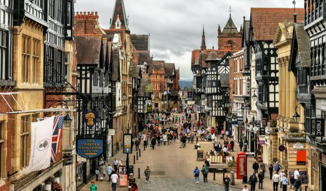
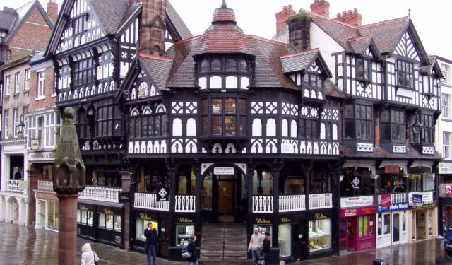
While the origins of Chester date back to Roman Times, much of the city center, and by far the greatest part of it, looks medieval. Indeed, if you visit the city, the first thing you notice is the magnificent black-and-white architecture. Despite their appearance, however, the majority of these buildings are Victorian by the time of construction.

The Black-and-White Revival was an architectural...  view more

Tour Duration: 1 Hour(s)
Travel Distance: 1.0 Km or 0.6 Miles