

Leicester Introduction Walking Tour (Self Guided), Leicester
Leicester is one of the oldest cities in England, whose history goes back almost two millennia. The Romans arrived in the area around 47 AD, during their conquest of southern Britain. Following the Saxon invasion, Leicester was then captured by Danish Vikings, in the 9th century.
The settlement was first documented in the early 10th century, under the name Ligeraceaster. At the time of the Norman Conquest in 1066, the town, then known as Ledecestre, was quite thriving. William the Conqueror's Domesday Book recorded it as having 322 houses and six churches, with a population of between 1,500 and 2,000. Medieval Leicester lay within the old Roman walls which followed the lines of today's Soar Lane, Sanvey Gate, Church Gate, Gallowtree Gate, Horsefair Street and Bath Lane.
The name Leicester comes from Old English and derives from Latin “Legorensis civitatis”. The former word is the name of a people, the Ligore, who came from the river Ligor (now the River Soar). The second element of the name is the Old English word ceaster which means "fort, fortification, town" (borrowed from Latin castrum).
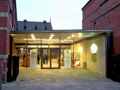
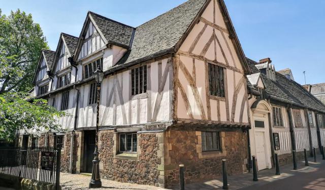
In the 12th-13th centuries Leicester underwent a development boom, and in the 14th century saw its prestige further enhanced. The timber-framed Leicester Guildhall (once acted as the town hall) dates from that period. At the end of the War of the Roses (mid-to-late 15th century), King Richard III met his end at the Battle of Bosworth Field near the town, and was buried in Leicester's Greyfriars Church. The burial site, demolished in 1538, was discovered in 2012 and is now covered by King Richard III Visitor Centre.
During the Industrial era, particularly throughout the reign of Queen Victoria, Leicester had prospered greatly. Between 1861 and 1901, its population had increased three-fold, to exceed 210,000, with the living conditions also generally improved.
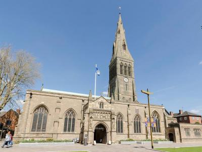
Leicester was finally recognized as a city in 1919 for its contribution to the British WWI effort. In 1927, Leicester became a cathedral city upon the consecration of St Martin's Church as Leicester Cathedral. The years after WWII, particularly from the 1960s onwards, brought many social and economic challenges to the city, as well as further expansion.
To check out Leicester's major attractions worthy of attention, take this self-guided walk and learn more about the past and present of this city in its variety!
The settlement was first documented in the early 10th century, under the name Ligeraceaster. At the time of the Norman Conquest in 1066, the town, then known as Ledecestre, was quite thriving. William the Conqueror's Domesday Book recorded it as having 322 houses and six churches, with a population of between 1,500 and 2,000. Medieval Leicester lay within the old Roman walls which followed the lines of today's Soar Lane, Sanvey Gate, Church Gate, Gallowtree Gate, Horsefair Street and Bath Lane.
The name Leicester comes from Old English and derives from Latin “Legorensis civitatis”. The former word is the name of a people, the Ligore, who came from the river Ligor (now the River Soar). The second element of the name is the Old English word ceaster which means "fort, fortification, town" (borrowed from Latin castrum).
In the 12th-13th centuries Leicester underwent a development boom, and in the 14th century saw its prestige further enhanced. The timber-framed Leicester Guildhall (once acted as the town hall) dates from that period. At the end of the War of the Roses (mid-to-late 15th century), King Richard III met his end at the Battle of Bosworth Field near the town, and was buried in Leicester's Greyfriars Church. The burial site, demolished in 1538, was discovered in 2012 and is now covered by King Richard III Visitor Centre.
During the Industrial era, particularly throughout the reign of Queen Victoria, Leicester had prospered greatly. Between 1861 and 1901, its population had increased three-fold, to exceed 210,000, with the living conditions also generally improved.
Leicester was finally recognized as a city in 1919 for its contribution to the British WWI effort. In 1927, Leicester became a cathedral city upon the consecration of St Martin's Church as Leicester Cathedral. The years after WWII, particularly from the 1960s onwards, brought many social and economic challenges to the city, as well as further expansion.
To check out Leicester's major attractions worthy of attention, take this self-guided walk and learn more about the past and present of this city in its variety!
How it works: Download the app "GPSmyCity: Walks in 1K+ Cities" from Apple App Store or Google Play Store to your mobile phone or tablet. The app turns your mobile device into a personal tour guide and its built-in GPS navigation functions guide you from one tour stop to next. The app works offline, so no data plan is needed when traveling abroad.
Download The GPSmyCity App
Leicester Introduction Walking Tour Map
Guide Name: Leicester Introduction Walking Tour
Guide Location: England » Leicester (See other walking tours in Leicester)
Guide Type: Self-guided Walking Tour (Sightseeing)
Tour Duration: 1 Hour(s)
Travel Distance: 1.1 Km or 0.7 Miles
Guide Location: England » Leicester (See other walking tours in Leicester)
Guide Type: Self-guided Walking Tour (Sightseeing)
Tour Duration: 1 Hour(s)
Travel Distance: 1.1 Km or 0.7 Miles
Sights Featured in This Walk
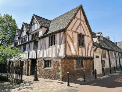
5) The Guildhall (must see)
Walking Tours in Leicester, England

Create Your Own Walk in Leicester
Creating your own self-guided walk in Leicester is easy and fun. Choose the city attractions that you want to see and a walk route map will be created just for you. You can even set your hotel as the start point of the walk.
Historical Buildings
Leicester, a city in England's East Midlands, has a storied past that is vividly presented in its historical buildings. Valuable architectural monuments, they are the city's pride and as such enjoy special protection by the government.
Among such, Magazine Gateway stands as a testament to the city's medieval legacy. Originally part of its defensive walls, this structure now... view more
Tour Duration: 2 Hour(s)
Travel Distance: 2.6 Km or 1.6 Miles
Among such, Magazine Gateway stands as a testament to the city's medieval legacy. Originally part of its defensive walls, this structure now... view more
Tour Duration: 2 Hour(s)
Travel Distance: 2.6 Km or 1.6 Miles
The Most Popular Cities
/ view all