

Roman Ruins Walking Tour (Self Guided), Regensburg
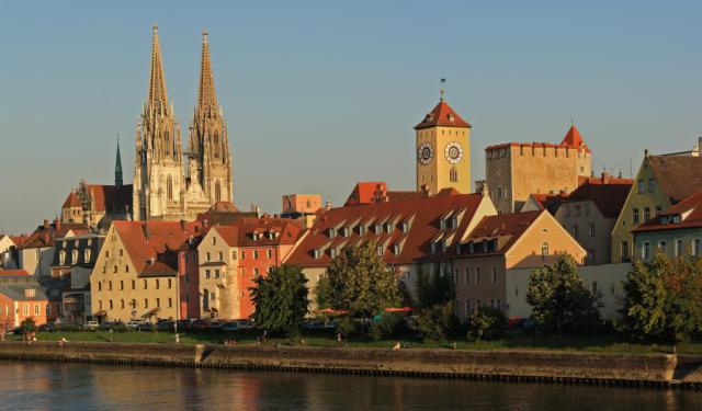
Meandering through the Old Town of Regensburg, it’s easy to forget that some 1800 years ago most of this area was occupied by a Roman fortress. Although the first settlement here dates from as early as the Stone Age, it is the Romans who put it firmly on the map.
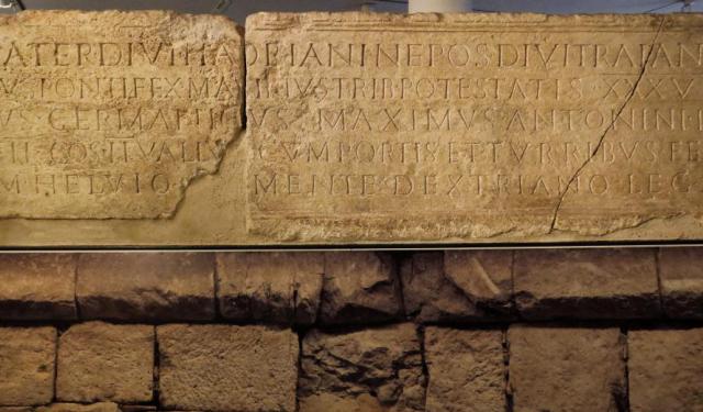
Around 90 AD, they first built an expeditionary and then a permanent military camp called Castra Regina ("Fortress by the River Regen"), in 179 AD, during the reign of Emperor Marcus Aurelius. Designed to accommodate the 3rd Italian Legion (Legio III Italica), the rectangular fort measured 540 x 450 meters and was fit to house up to 6,000 soldiers.
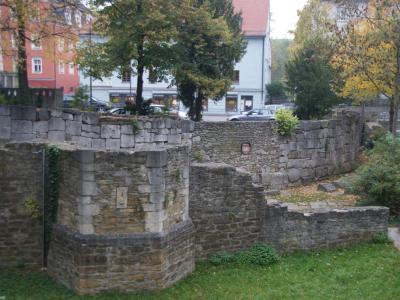
Important for its location, at the junction of the Danube and Regen rivers, this outpost formed part of the Roman Empire’s northern frontier (the so-called Danubian Limes) and corresponded roughly to what is now the core of Regensburg's Altstadt (Old Town). It was surrounded by a mighty wall comprising large ashlars with towers and a wide moat in front of it.
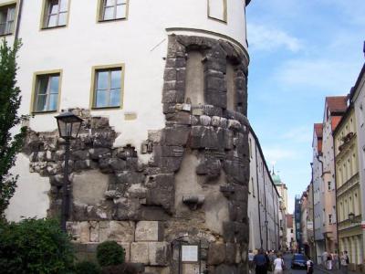
By the 3rd century AD, the camp had an extensive civilian suburb with residential and commercial buildings, shops, villas, sanctuaries, and a large bathing complex ("therme"). In the 5th century, constant Barbarian raids and migrations forced the Romans to abandon the fort, but the large ashlar wall of the legionary camp continued to protect the early medieval town long after they left. The east side of the fortress wall served as a city wall during the High Middle Ages and was repaired accordingly; hence the large portions thereof have been preserved.
Today, traces of the Roman-era buildings and remnants of the legionary camp fortifications are found both under and above ground in the heart of Regensburg. Perhaps the most prominent of them is the former north gate to Castra Regina, called Porta Praetoria, the largest surviving Roman building in Bavaria.
Other impressive relics include a long section of the Roman wall uncovered during the construction of a multi-story car park in Dachau Square (Dachauplatz), as well as fragments of the north- and south-east corners of the wall that once encircled the Roman camp. Together they are featured in the multimedia "Legion Camp Wall Document" ("Document Legionslagermauer”).
If Regensburg is "The Jewel of Bavaria", then Castra Regina is undoubtedly the jewel of its Roman part. To learn more about the Roman legacy of this former imperial outpost in the Danubian region, take our self-guided historical tour.
Around 90 AD, they first built an expeditionary and then a permanent military camp called Castra Regina ("Fortress by the River Regen"), in 179 AD, during the reign of Emperor Marcus Aurelius. Designed to accommodate the 3rd Italian Legion (Legio III Italica), the rectangular fort measured 540 x 450 meters and was fit to house up to 6,000 soldiers.
Important for its location, at the junction of the Danube and Regen rivers, this outpost formed part of the Roman Empire’s northern frontier (the so-called Danubian Limes) and corresponded roughly to what is now the core of Regensburg's Altstadt (Old Town). It was surrounded by a mighty wall comprising large ashlars with towers and a wide moat in front of it.
By the 3rd century AD, the camp had an extensive civilian suburb with residential and commercial buildings, shops, villas, sanctuaries, and a large bathing complex ("therme"). In the 5th century, constant Barbarian raids and migrations forced the Romans to abandon the fort, but the large ashlar wall of the legionary camp continued to protect the early medieval town long after they left. The east side of the fortress wall served as a city wall during the High Middle Ages and was repaired accordingly; hence the large portions thereof have been preserved.
Today, traces of the Roman-era buildings and remnants of the legionary camp fortifications are found both under and above ground in the heart of Regensburg. Perhaps the most prominent of them is the former north gate to Castra Regina, called Porta Praetoria, the largest surviving Roman building in Bavaria.
Other impressive relics include a long section of the Roman wall uncovered during the construction of a multi-story car park in Dachau Square (Dachauplatz), as well as fragments of the north- and south-east corners of the wall that once encircled the Roman camp. Together they are featured in the multimedia "Legion Camp Wall Document" ("Document Legionslagermauer”).
If Regensburg is "The Jewel of Bavaria", then Castra Regina is undoubtedly the jewel of its Roman part. To learn more about the Roman legacy of this former imperial outpost in the Danubian region, take our self-guided historical tour.
How it works: Download the app "GPSmyCity: Walks in 1K+ Cities" from Apple App Store or Google Play Store to your mobile phone or tablet. The app turns your mobile device into a personal tour guide and its built-in GPS navigation functions guide you from one tour stop to next. The app works offline, so no data plan is needed when traveling abroad.
Download The GPSmyCity App
Roman Ruins Walking Tour Map
Guide Name: Roman Ruins Walking Tour
Guide Location: Germany » Regensburg (See other walking tours in Regensburg)
Guide Type: Self-guided Walking Tour (Sightseeing)
Tour Duration: 1 Hour(s)
Travel Distance: 1.4 Km or 0.9 Miles
Guide Location: Germany » Regensburg (See other walking tours in Regensburg)
Guide Type: Self-guided Walking Tour (Sightseeing)
Tour Duration: 1 Hour(s)
Travel Distance: 1.4 Km or 0.9 Miles
Sights Featured in This Walk


Walking Tours in Regensburg, Germany

Create Your Own Walk in Regensburg
Creating your own self-guided walk in Regensburg is easy and fun. Choose the city attractions that you want to see and a walk route map will be created just for you. You can even set your hotel as the start point of the walk.
Regensburg Introduction Walking Tour
During a battle in 1809, Napoleon remarked that Regensburg was “worth a crown.”
The name “Regensburg” reflects its roots: it comes from the River Regen, which joins the Danube here, and the Old High German word burg, meaning fortress-so Regensburg means “the fortress by the Regen.”
Long before the Romans, Celtic tribes had already settled on the high ground, taking advantage of... view more
Tour Duration: 2 Hour(s)
Travel Distance: 4.1 Km or 2.5 Miles
The Most Popular Cities
/ view all