

Audio Guide: Oia Walking Tour (Self Guided), Santorini
Oia is one of the oldest settlements on Santorini, with a history shaped by geography, seafaring, and repeated cycles of destruction and rebuilding. The village occupies the northwestern edge of the island, set along the rim of the volcanic caldera. This elevated position offered both strategic advantages and exposure to natural forces, particularly earthquakes, which have repeatedly altered the settlement’s form. The name Oia is generally linked to the ancient Greek word oia, which referred to dwellings or inhabited places.
Archaeological evidence suggests that the broader area of northern Santorini was inhabited from antiquity, though Oia itself developed more clearly as a structured settlement during the Byzantine and post-Byzantine periods. By the 17th and 18th centuries, Oia had grown into a prosperous maritime community. Its economy relied heavily on shipping, trade, and ship ownership, with local captains sailing as far as Russia, Egypt, and the Black Sea. Wealth from this activity financed the construction of substantial homes, known as captains’ houses, as well as churches and storage facilities carved into the volcanic rock.
The 19th century marked the peak of Oia’s prosperity, but this period was followed by gradual decline. Changes in maritime trade routes, the introduction of steamships, and competition from larger ports reduced the importance of small island fleets. Emigration increased, and the population steadily fell. The most dramatic turning point came in 1956, when a powerful earthquake caused widespread destruction across Santorini. In Oia, many buildings collapsed or were left uninhabitable, accelerating depopulation and abandonment.
Recovery began slowly in the late 20th century. Restoration efforts focused on preserving traditional architecture, including cave houses, whitewashed facades, and blue-domed churches. These efforts coincided with the growth of tourism, which reshaped Oia’s economy and public image.
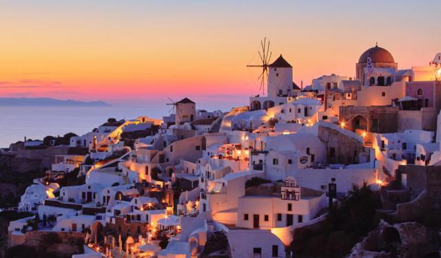
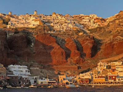
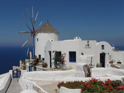
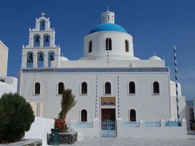
Walking through Oia, you encounter layered landmarks in quick succession. Below the cliffs, Amoudi Bay opens onto a small harbor lined with boats and taverns. Above, the restored windmill marks the village skyline. The path leads to Oia Castle, where fortifications frame caldera views. Nearby, the Naval Maritime Museum recalls the town’s seafaring past, while the Church of Panagia Platsani anchors daily life with its bright dome and quiet square, set along the volcanic rim.
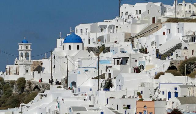
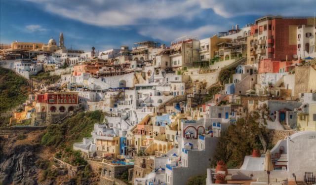
Today, Oia is internationally known for its cliff-cut settlement shaped directly into volcanic rock, where cave houses and former captains’ residences step down the caldera rim. Its identity remains closely tied to seafaring life, from fortified viewpoints above to the working harbour of Amoudi Bay below.
Archaeological evidence suggests that the broader area of northern Santorini was inhabited from antiquity, though Oia itself developed more clearly as a structured settlement during the Byzantine and post-Byzantine periods. By the 17th and 18th centuries, Oia had grown into a prosperous maritime community. Its economy relied heavily on shipping, trade, and ship ownership, with local captains sailing as far as Russia, Egypt, and the Black Sea. Wealth from this activity financed the construction of substantial homes, known as captains’ houses, as well as churches and storage facilities carved into the volcanic rock.
The 19th century marked the peak of Oia’s prosperity, but this period was followed by gradual decline. Changes in maritime trade routes, the introduction of steamships, and competition from larger ports reduced the importance of small island fleets. Emigration increased, and the population steadily fell. The most dramatic turning point came in 1956, when a powerful earthquake caused widespread destruction across Santorini. In Oia, many buildings collapsed or were left uninhabitable, accelerating depopulation and abandonment.
Recovery began slowly in the late 20th century. Restoration efforts focused on preserving traditional architecture, including cave houses, whitewashed facades, and blue-domed churches. These efforts coincided with the growth of tourism, which reshaped Oia’s economy and public image.
Walking through Oia, you encounter layered landmarks in quick succession. Below the cliffs, Amoudi Bay opens onto a small harbor lined with boats and taverns. Above, the restored windmill marks the village skyline. The path leads to Oia Castle, where fortifications frame caldera views. Nearby, the Naval Maritime Museum recalls the town’s seafaring past, while the Church of Panagia Platsani anchors daily life with its bright dome and quiet square, set along the volcanic rim.
Today, Oia is internationally known for its cliff-cut settlement shaped directly into volcanic rock, where cave houses and former captains’ residences step down the caldera rim. Its identity remains closely tied to seafaring life, from fortified viewpoints above to the working harbour of Amoudi Bay below.
How it works: Download the app "GPSmyCity: Walks in 1K+ Cities" from Apple App Store or Google Play Store to your mobile phone or tablet. The app turns your mobile device into a personal tour guide and its built-in GPS navigation functions guide you from one tour stop to next. The app works offline, so no data plan is needed when traveling abroad.
Download The GPSmyCity App
Oia Walking Tour Map
Guide Name: Oia Walking Tour
Guide Location: Greece » Santorini (See other walking tours in Santorini)
Guide Type: Self-guided Walking Tour (Sightseeing)
Tour Duration: 1 Hour(s)
Travel Distance: 1.0 Km or 0.6 Miles
Guide Location: Greece » Santorini (See other walking tours in Santorini)
Guide Type: Self-guided Walking Tour (Sightseeing)
Tour Duration: 1 Hour(s)
Travel Distance: 1.0 Km or 0.6 Miles
Sights Featured in This Walk
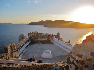
3) Oia Castle (must see)

Walking Tours in Santorini, Greece

Create Your Own Walk in Santorini
Creating your own self-guided walk in Santorini is easy and fun. Choose the city attractions that you want to see and a walk route map will be created just for you. You can even set your hotel as the start point of the walk.
Firostefani and Imerovigli Walking Tour
Away from the crowded Fira yet close to the famous Santorini caldera, there are two small settlements: Firostefani and Imerovigli. Each of these gorgeous neighborhoods has something unique to offer, and thus represents an attraction in its own right.
The quaint village of Firostefani, whose name translates as "The Crown of Fira", is now considered a suburb of Santorini's capital,... view more
Tour Duration: 1 Hour(s)
Travel Distance: 2.3 Km or 1.4 Miles
The quaint village of Firostefani, whose name translates as "The Crown of Fira", is now considered a suburb of Santorini's capital,... view more
Tour Duration: 1 Hour(s)
Travel Distance: 2.3 Km or 1.4 Miles
Fira Walking Tour
Known in antiquity as Thera, the island was originally a roughly circular landmass shaped by volcanic activity in the southern Aegean. Its earliest known settlement dates to the Neolithic period, but Santorini entered history more clearly during the Bronze Age, when it developed into an important center of Cycladic and later Minoan civilization.
Around the 17th century BCE, Santorini... view more
Tour Duration: 2 Hour(s)
Travel Distance: 3.4 Km or 2.1 Miles
Around the 17th century BCE, Santorini... view more
Tour Duration: 2 Hour(s)
Travel Distance: 3.4 Km or 2.1 Miles
The Most Popular Cities
/ view all