

Audio Guide: Fira Walking Tour (Self Guided), Santorini
Known in antiquity as Thera, the island was originally a roughly circular landmass shaped by volcanic activity in the southern Aegean. Its earliest known settlement dates to the Neolithic period, but Santorini entered history more clearly during the Bronze Age, when it developed into an important center of Cycladic and later Minoan civilization.
Around the 17th century BCE, Santorini experienced one of the most powerful volcanic eruptions in recorded history. The eruption caused much of the island to collapse inward, forming the flooded caldera that defines the landscape today. Ash and pumice buried settlements such as Akrotiri, preserving them in remarkable detail. The eruption had far-reaching effects across the eastern Mediterranean and is often associated with the decline of Minoan power on Crete.
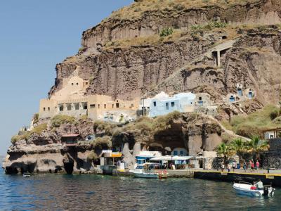
After centuries of reduced habitation, the island was resettled in antiquity. Under Roman and later Byzantine rule, Santorini became part of wider political and religious networks. Christianity reached the island early, and churches and small monastic communities appeared across the landscape. Although its isolation limited large-scale urban expansion, Fira emerged as a focal point of local governance and daily life, benefiting from its commanding position above the natural harbor below.
From the 13th to the 16th centuries, Santorini was ruled by Venetian families, most notably the Sanudo dynasty, before passing under Ottoman control. Despite political shifts, the island maintained a strong agricultural economy. The volcanic soil proved especially suited to viticulture, shaping both the rural landscape and the enduring identity of Santorini and its capital, Fira.
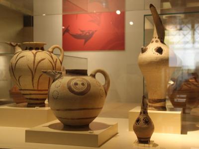
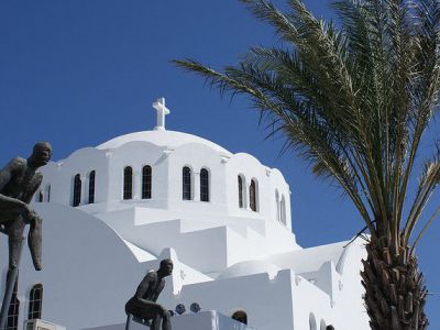
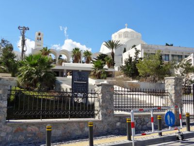
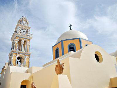
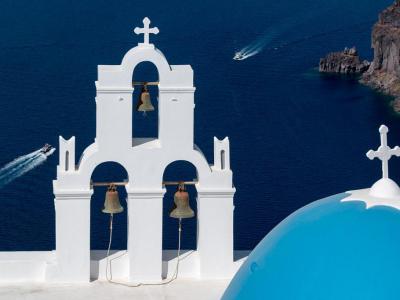
Within Fira’s compact center, several landmarks anchor Santorini’s history and skyline. The Museum of Prehistoric Thera presents finds, including wall paintings, pottery, and everyday objects preserved by volcanic ash, offering a clear picture of Bronze Age life. Nearby stands the Cathedral of Saint John the Baptist, a 19th-century Catholic church with a restrained facade and calm interior. Just beyond, the Three Bells of Fira mark one of the island’s most recognizable viewpoints, where a blue dome and bell tower frame the caldera below.
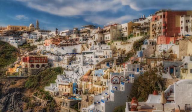
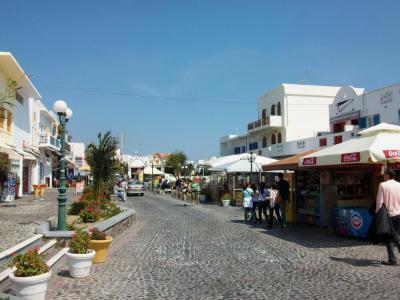
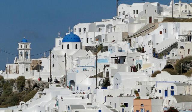
Today, Santorini is defined by its carefully shaped architectural landscape. Whitewashed houses, terraced along the caldera cliffs, create the romantic image that has made the island one of the world’s most sought-after destinations.
Around the 17th century BCE, Santorini experienced one of the most powerful volcanic eruptions in recorded history. The eruption caused much of the island to collapse inward, forming the flooded caldera that defines the landscape today. Ash and pumice buried settlements such as Akrotiri, preserving them in remarkable detail. The eruption had far-reaching effects across the eastern Mediterranean and is often associated with the decline of Minoan power on Crete.
After centuries of reduced habitation, the island was resettled in antiquity. Under Roman and later Byzantine rule, Santorini became part of wider political and religious networks. Christianity reached the island early, and churches and small monastic communities appeared across the landscape. Although its isolation limited large-scale urban expansion, Fira emerged as a focal point of local governance and daily life, benefiting from its commanding position above the natural harbor below.
From the 13th to the 16th centuries, Santorini was ruled by Venetian families, most notably the Sanudo dynasty, before passing under Ottoman control. Despite political shifts, the island maintained a strong agricultural economy. The volcanic soil proved especially suited to viticulture, shaping both the rural landscape and the enduring identity of Santorini and its capital, Fira.
Within Fira’s compact center, several landmarks anchor Santorini’s history and skyline. The Museum of Prehistoric Thera presents finds, including wall paintings, pottery, and everyday objects preserved by volcanic ash, offering a clear picture of Bronze Age life. Nearby stands the Cathedral of Saint John the Baptist, a 19th-century Catholic church with a restrained facade and calm interior. Just beyond, the Three Bells of Fira mark one of the island’s most recognizable viewpoints, where a blue dome and bell tower frame the caldera below.
Today, Santorini is defined by its carefully shaped architectural landscape. Whitewashed houses, terraced along the caldera cliffs, create the romantic image that has made the island one of the world’s most sought-after destinations.
How it works: Download the app "GPSmyCity: Walks in 1K+ Cities" from Apple App Store or Google Play Store to your mobile phone or tablet. The app turns your mobile device into a personal tour guide and its built-in GPS navigation functions guide you from one tour stop to next. The app works offline, so no data plan is needed when traveling abroad.
Download The GPSmyCity App
Fira Walking Tour Map
Guide Name: Fira Walking Tour
Guide Location: Greece » Santorini (See other walking tours in Santorini)
Guide Type: Self-guided Walking Tour (Sightseeing)
Tour Duration: 2 Hour(s)
Travel Distance: 3.4 Km or 2.1 Miles
Guide Location: Greece » Santorini (See other walking tours in Santorini)
Guide Type: Self-guided Walking Tour (Sightseeing)
Tour Duration: 2 Hour(s)
Travel Distance: 3.4 Km or 2.1 Miles
Sights Featured in This Walk
Walking Tours in Santorini, Greece

Create Your Own Walk in Santorini
Creating your own self-guided walk in Santorini is easy and fun. Choose the city attractions that you want to see and a walk route map will be created just for you. You can even set your hotel as the start point of the walk.
Firostefani and Imerovigli Walking Tour
Away from the crowded Fira yet close to the famous Santorini caldera, there are two small settlements: Firostefani and Imerovigli. Each of these gorgeous neighborhoods has something unique to offer, and thus represents an attraction in its own right.
The quaint village of Firostefani, whose name translates as "The Crown of Fira", is now considered a suburb of Santorini's capital,... view more
Tour Duration: 1 Hour(s)
Travel Distance: 2.3 Km or 1.4 Miles
The quaint village of Firostefani, whose name translates as "The Crown of Fira", is now considered a suburb of Santorini's capital,... view more
Tour Duration: 1 Hour(s)
Travel Distance: 2.3 Km or 1.4 Miles
Oia Walking Tour
Oia is one of the oldest settlements on Santorini, with a history shaped by geography, seafaring, and repeated cycles of destruction and rebuilding. The village occupies the northwestern edge of the island, set along the rim of the volcanic caldera. This elevated position offered both strategic advantages and exposure to natural forces, particularly earthquakes, which have repeatedly altered the... view more
Tour Duration: 1 Hour(s)
Travel Distance: 1.0 Km or 0.6 Miles
Tour Duration: 1 Hour(s)
Travel Distance: 1.0 Km or 0.6 Miles
The Most Popular Cities
/ view all