


Audio Guide: Old Colombo Walking Tour (Self Guided), Colombo
Old Colombo developed as a port settlement long before it became the capital of modern Sri Lanka, shaped by its natural harbor and strategic position along Indian Ocean trade routes. From at least the early centuries BCE, the area attracted merchants trading spices, gemstones, elephants, and textiles. Arab traders were particularly influential, establishing early Muslim communities near the harbor, followed by contacts with Indian, Chinese, Greek, and Roman merchants. By the medieval period, Colombo was already a recognized maritime hub, connected to both regional and long-distance trade networks.
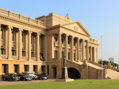
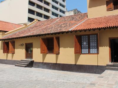
A decisive shift came in the early 16th century with the arrival of the Portuguese. They fortified the harbor area and established what is now known as the Colombo Fort district, transforming this part of Old Colombo into a colonial stronghold focused on trade control and military defense. Around the fort, local communities and traders settled in adjoining areas, laying the foundations for the broader Old Colombo urban area. When the Dutch took control in 1656, they expanded the fortifications and reorganized the town along more formal lines, introducing canals, warehouses, hospitals, and administrative buildings. The Dutch Hospital and elements of the historic street layout within Old Colombo date from this period.
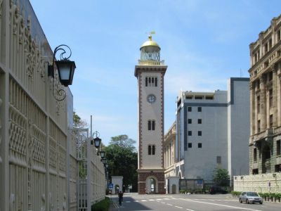
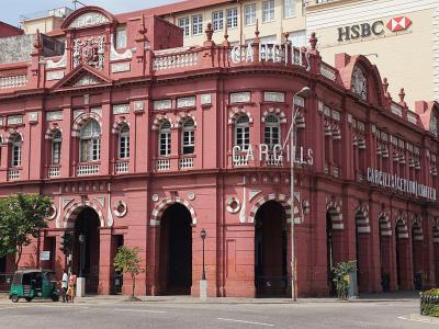
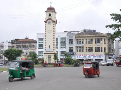
Under British rule, beginning in 1796, Old Colombo evolved from a fortified town into a colonial administrative city. Much of the defensive wall system was dismantled, and the city expanded outward, yet the historic core retained its commercial importance. Within Old Colombo, Fort became the center of government offices, banks, and trading houses, while Pettah, the neighboring district just inland, developed into a dense mercantile area. Pettah’s grid of streets adopted specialized functions, with individual roads associated with textiles, spices, metals, or household goods, a pattern that remains visible today.
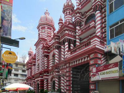
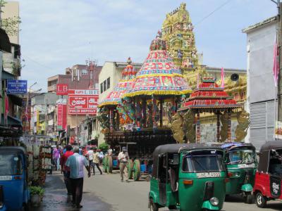
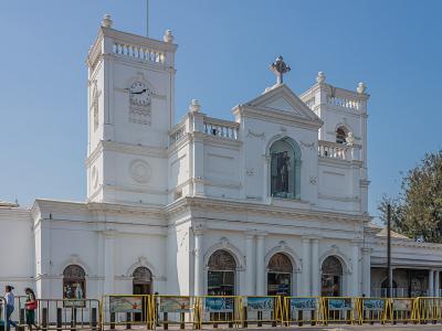
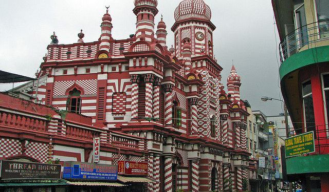
Alongside these commercial districts, religious and ethnic quarters also took shape within Old Colombo. Kochchikade neighborhood, together with parts of Pettah, became known for its churches, mosques, and Hindu temples, reflecting the coexistence of Catholic, Muslim, Hindu, and Buddhist communities. Landmarks such as Saint Anthony’s Shrine, Jami-Ul-Alfar Mosque, and Sri Kailawasanatan Swami Temple illustrate this layered religious landscape within a compact area.
By the late 19th and early 20th centuries, Old Colombo had become the island’s economic heart, linking the port, railways, and markets. Although the city later expanded south and east, Old Colombo-encompassing Fort, Pettah, and Kochchikade-retained its role as a commercial and institutional center. Today, walking through these districts means tracing the same paths once shaped by merchants and empires, a reminder that the city’s story, which began at the water’s edge, still flows through its streets.
A decisive shift came in the early 16th century with the arrival of the Portuguese. They fortified the harbor area and established what is now known as the Colombo Fort district, transforming this part of Old Colombo into a colonial stronghold focused on trade control and military defense. Around the fort, local communities and traders settled in adjoining areas, laying the foundations for the broader Old Colombo urban area. When the Dutch took control in 1656, they expanded the fortifications and reorganized the town along more formal lines, introducing canals, warehouses, hospitals, and administrative buildings. The Dutch Hospital and elements of the historic street layout within Old Colombo date from this period.
Under British rule, beginning in 1796, Old Colombo evolved from a fortified town into a colonial administrative city. Much of the defensive wall system was dismantled, and the city expanded outward, yet the historic core retained its commercial importance. Within Old Colombo, Fort became the center of government offices, banks, and trading houses, while Pettah, the neighboring district just inland, developed into a dense mercantile area. Pettah’s grid of streets adopted specialized functions, with individual roads associated with textiles, spices, metals, or household goods, a pattern that remains visible today.
Alongside these commercial districts, religious and ethnic quarters also took shape within Old Colombo. Kochchikade neighborhood, together with parts of Pettah, became known for its churches, mosques, and Hindu temples, reflecting the coexistence of Catholic, Muslim, Hindu, and Buddhist communities. Landmarks such as Saint Anthony’s Shrine, Jami-Ul-Alfar Mosque, and Sri Kailawasanatan Swami Temple illustrate this layered religious landscape within a compact area.
By the late 19th and early 20th centuries, Old Colombo had become the island’s economic heart, linking the port, railways, and markets. Although the city later expanded south and east, Old Colombo-encompassing Fort, Pettah, and Kochchikade-retained its role as a commercial and institutional center. Today, walking through these districts means tracing the same paths once shaped by merchants and empires, a reminder that the city’s story, which began at the water’s edge, still flows through its streets.
How it works: Download the app "GPSmyCity: Walks in 1K+ Cities" from Apple App Store or Google Play Store to your mobile phone or tablet. The app turns your mobile device into a personal tour guide and its built-in GPS navigation functions guide you from one tour stop to next. The app works offline, so no data plan is needed when traveling abroad.
Download The GPSmyCity App
Old Colombo Walking Tour Map
Guide Name: Old Colombo Walking Tour
Guide Location: Sri Lanka » Colombo (See other walking tours in Colombo)
Guide Type: Self-guided Walking Tour (Sightseeing)
Tour Duration: 2 Hour(s)
Travel Distance: 2.9 Km or 1.8 Miles
Guide Location: Sri Lanka » Colombo (See other walking tours in Colombo)
Guide Type: Self-guided Walking Tour (Sightseeing)
Tour Duration: 2 Hour(s)
Travel Distance: 2.9 Km or 1.8 Miles
Sights Featured in This Walk
Walking Tours in Colombo, Sri Lanka

Create Your Own Walk in Colombo
Creating your own self-guided walk in Colombo is easy and fun. Choose the city attractions that you want to see and a walk route map will be created just for you. You can even set your hotel as the start point of the walk.
Colombo Introduction Walking Tour
Colombo, the commercial capital and largest city of Sri Lanka, has a history shaped by centuries of trade, colonization, and cultural exchange. Strategically positioned on the island’s western coast along the Indian Ocean, it has served as an important port city for more than 2,000 years. Early maritime accounts and Sri Lankan chronicles describe Colombo as a hub for spices, gemstones, and other... view more
Tour Duration: 3 Hour(s)
Travel Distance: 5.5 Km or 3.4 Miles
Tour Duration: 3 Hour(s)
Travel Distance: 5.5 Km or 3.4 Miles
The Most Popular Cities
/ view all